Deep dive into record Summer humidity - Is this year an anomaly?

NORTH TEXAS (CBSNewsTexas.com) - Is a warming Gulf of Mexico going to make our summers even more miserable here in North Texas?
By mid-August, the DFW airport had logged 36 days where the daytime high hit 100° or higher. This puts us 12th on the list of most in the year. We are only halfway through the month. August averages the MOST 100° days in Summer.
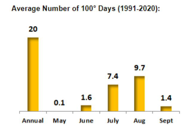
In the current forecast, we believe the DFW airport gets into a "top-10" year with over 40 days at or above 100°. It is already the sixth hottest summer on record.
Most have noticed the humidity this summer. Well, something really stands out about this year when compared with other "top-10" hottest summers.
Now some of this is going to get a little geeky. This is how I spend my lunch hours while on shift, looking for unusual trends in climatology.
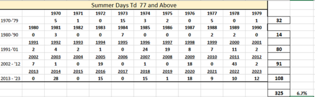
Using June 1 to August 31 to define "summer," I looked at all summers since 1970 and found out that of all those summer days, the maximum dewpoint reached 77° or higher only 7% of the time, or 325 out of 4,876 possible days.
So super-sticky humid air, or a dewpoint at 77° or higher, is fortunately rare in North Texas. Even though our climate is described as "Coastal Plain" because of our proximity to the Gulf of Mexico, we still get enough dry air from our west to keep the worst at bay.
When I looked at these top 20 years, there is a big difference in the average since 1970. Hourly dewpoint observations only go back to 1954 for DFW.
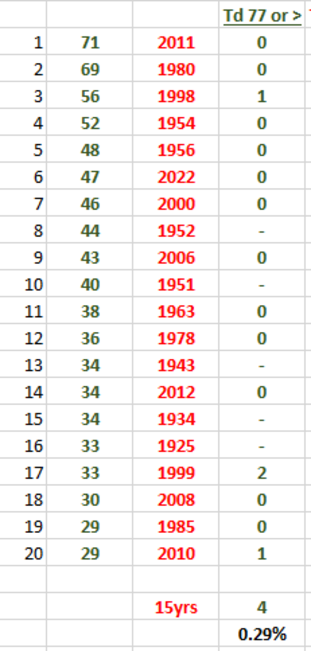
Instead of 7% of the days hitting a maximum dewpoint of 77° or higher, in hot years that drops all the way down to about a third of one percent (0.29%). Of the total possible summer days (1,365) in these years, only four days had a maximum dewpoint of 77°.
This makes sense, dry air heats up easier than moist air. Some of our driest years are also some of our hottest summers.
But this year? If this goes down as one of the warmer summers (already in the top 10) and with a top-20 number of 100° days, then something really stands out.
As of Aug. 14, a total of 12 days logged high dewpoints (77° or higher). This means 20% of summer days so far would be described as super humid, including two days where the dewpoint hit 80°. That's happened only three other days since 1980.
So, in summary, in a really hot summer, you'd expect only about 1 in 300 days to have a maximum dewpoint of 77° or higher. This summer it's more like 1 in 5. That's a huge difference and perhaps, hopefully, just a strange anomaly.
High dewpoints mean a higher heat index. This summer, back in June, we had the Heat Index hit 117܄° at DFW which ties for the highest one ever recorded.
I should mention that during your typical summer day, there is vertical mixing of the atmosphere across the afternoon that brings down the dewpoint from the morning when usually the "maximum" dewpoint is logged. Still, when you start with a dewpoint that high (77° or higher) in the morning, you usually end up with a Heat Advisory or Excessive heat warning that day when the temperature is forecast to hit 100° or higher.
So, in summary, in a really hot summer, you'd expect only about 1 in 300 days to have a maximum dewpoint of 77° or higher. This summer it's more like 1 in 6.
But is this a one-and-done kind of anomaly? There is something else going on that might suggest we are heading to more summers like this one. It has to do with the Gulf of Mexico. You might have heard that the entire ocean is getting warmer.
Well, the Gulf is warming at twice the rate.
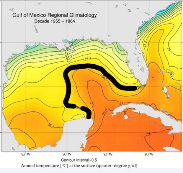
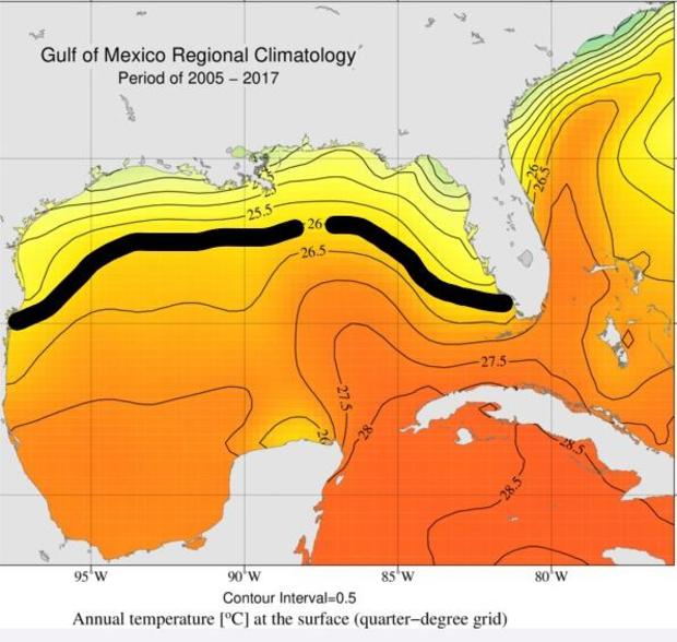
Scientists at NOAA have shown that the Gulf has warmed 1.8°F from 1970 to 2020. Compare the two pictures below. I outlined where the average water temperature of 26°C (78.8°F) was in 1955-1964 compared with 2005-2017. It is much closer to the Texas coast and much larger. Keep in mind this is the annual average temperature, not the summer. In the summer, the waters are much warmer.
Since our prevailing wind during summer is from the south, this wind taps into the humidity coming off the warm Gulf and brings it into North Texas.
Remember the phrase "Coastal Plain"? That's the "coastal" part, one of our main weather ingredients around here is Gulf moisture. The warmer the water, the higher the humidity.
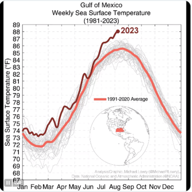
The waters in the Gulf have continued to warm. This summer it is breaking records. No, let me correct that. This summer it is shattering records. Waters this warm could drive up our humidity during our hottest months.
This has been a rather deep dive into humidity and hot summers and I thank you for sticking to the end of this. Only time will tell if a much warmer-than-normal Gulf means a more humid summer for North Texas. We know how the overall temperature of summer has been going for the Metroplex. Last year was the fourth warmest summer on record, this summer so far is the sixth warmest on record. Since 2006, half of the 10 warmest summers ever in our history have occurred (#1 is 2011). Cranking up the humidity with this will only increase the misery index. Ugh.


