Study: Earth's groundwater basins may sink for decades if levels don't rebound
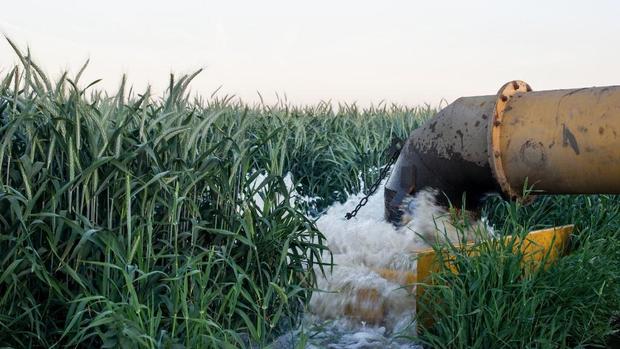
The San Joaquin Valley is the perfect place for farming -- almost. While the region has plenty of sun and fertile soil, it lacks a key requisite for sustainable agriculture: abundant water.
Parts of the valley are nearly as dry as a desert, and for many farmers there is only one reliable way to irrigate their land: pump water from the ground. This strategy has helped turn arid scrubland into lush plantations of fruit trees and row crops.
But it has come with a great cost. Over-pumping of San Joaquin Valley's groundwater basins has caused the region's surface to slowly collapse. According to scientists with NASA, who have used satellite radar data to analyze the problem, the ground has dropped nearly 30 feet in large areas of the valley since the 1920s as the substrate below, sucked dry of water, contracted like a dry sponge.
This decline of the Earth's surface -- called subsidence by geologists -- has damaged bridges and disrupted the flow of canals, reducing their capacity to transfer water. In 2014, California lawmakers passed the Sustainable Groundwater Management Act, a package of legislation that aims to resolve the state's groundwater overdraft -- and related problems, including subsidence -- by imposing regional regulations on pumping and, hopefully, stabilizing declining water tables.
This may not be enough to stop the drop of the Earth's surface, however. In a paper published Thursday in the journal Water Resources Research, Matthew Lees and Rosemary Knight, both of Stanford University, warn that the Earth's surface will continue sinking for decades or even centuries if underground water levels aren't allowed to rebound.
The authors' conclusion contradicts assumptions that merely stopping the decline of water tables is sufficient to halt land subsidence above.
To produce their findings, the scientists developed a modeling program that simulated subsidence near the city of Hanford, in the Kaweah groundwater subbasin, from 1952 to 2017. They also used private well data, acquired from property owners and local agencies, to create a subsurface map of the region's substrate types.
Lees and Knight concluded that previous research had underestimated the timescale over which clay substrate -- the type most strongly associated with subsidence -- contracts when it is drained dry.
"We suggest that residual compaction of clays is a process that continues for decades-to-centuries, indicating that to significantly reduce subsidence requires some recovery of head, not just a stabilization," the authors wrote in their paper.
In an interview, Knight, a professor of geophysics at Stanford's School of Earth, Energy & Environmental Sciences, said that if groundwater levels were stabilized now in the study area, subsidence would continue at a rate of about 10 centimeters per year for 30 years -- another 10 feet of depression.
As for preventing further subsidence, that will be no easy feat in a region of chronic water shortages.
"We would need to raise the water levels 10 meters," Knight said.
The findings call into question how effective the Sustainable Groundwater Management Act will be in reversing the impacts of groundwater overdraft. The law, usually referred to as SGMA, mandates the creation of local groundwater agencies -- teams of stakeholders who must draft and implement new regulations on pumping from wells, with the goal of curbing the rates of withdrawals so they at least match recharge rates by 2040.
Land subsidence is one of several undesirable outcomes of groundwater overuse that SGMA aims to mitigate.
But because groundwater managers don't have access -- at least not yet -- to the highly developed modeling system that Lees and Knight used, their groundwater management plans could fall short of SGMA's objectives, according to the authors.
"They'll wind up with groundwater sustainability plans that underestimate the amount of subsidence that's going to occur," Knight said.
To Peter Gleick, a senior fellow at the Pacific Institute, an Oakland-based think tank that addresses climate change, water supply and growth issues, the new Stanford research underscores the need to aggressively enforce groundwater use regulations that "actually increase recharge of depleted aquifers."
"It's been apparent for some time that the SGMA is insufficient and too slow to come into effect," says Gleick, who was not involved in the research. "This study raises a new challenge: even stopping groundwater overdraft, which won't actually happen for many years, won't be enough to prevent additional land subsidence because of the slower response of soils."
Gleick notes that pilot-scale recharge efforts are being conducted in some groundwater basins.
"But more needs to be done, faster," he says.
As a megadrought parches the West, groundwater use is expected to accelerate as surface supplies decline and become more unreliable. The Water Foundation -- an Oakland-based water equity group -- has estimated that as many as 12,000 residential wells could go dry in California by 2040 as a result of unsustainable groundwater use.
Knight says the modeling approach she and Lees used in their research, though it was derived from a small region of the San Joaquin Valley, can likely be applied to just about any alluvial aquifer system in the world.
She says she hopes to make the technology publicly accessible via web-based software so that state officials and groundwater agencies -- "For everyone," she says -- can accurately assess how their plans will affect, and hopefully prevent, future land subsidence.