Traffic moving slowly past Highway 1 washout near Big Sur, area parks closed
SAN FRANCISCO -- Authorities urged motorists to avoid California's scenic Highway 1 after a section of the coastal route collapsed during an Easter weekend storm, forcing closures and stranding motorists near Big Sur, authorities said.
All California state parks in the Big Sur area are now closed to day use and camping, the park service said Sunday night.
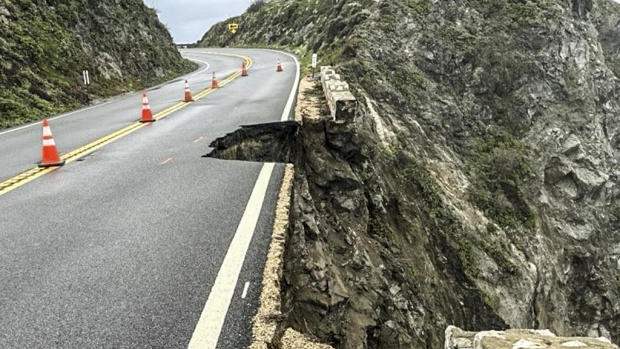
The collapse occurred amid heavy rain Saturday afternoon near Rocky Creek Bridge about 17 miles south of Monterey, sending chunks of asphalt tumbling into the ocean from the southbound side of the two-lane road.
The highway was closed in both directions in the mountainous area of California's central coast as engineers assessed the damage, said the state Department of Transportation (Caltrans).
"We are working on a plan to get motorists evacuated from the area," the California Highway Patrol said Saturday.
Pfeiffer Big Sur State Park, Andrew Molera State Park, Limekiln State Park, Julia Pfeiffer Burns State Park and Point Sur State Historic Park will remain closed until the road can be repaired.
Around noon on Sunday, crews had determined that travel in the northbound lane was safe and authorities began periodically escorting motorists around the damaged section. About 300 cars were waiting to travel northbound when officials led the first convoy through the area, the San Francisco Chronicle reported.
Some stranded motorists had slept in their cars overnight while others were sheltered at the nearby Big Sur Lodge, the newspaper said.
Caltrans spokesperson Kevin Drabinski said periodic convoys would continue over the coming days as crews shore up the highway, which had other closures because of rocks and debris in lanes. He urged people to avoid the area.
Only residents with proof of residency will be allowed into the area with California Highway Patrol and Caltrans escorts, though people who need to work in the area will also be permitted to enter.
Road information and updates can also be found on Caltrans District 5 social media platforms: Twitter at @CaltransD5, Facebook at Caltrans Central Coast (District 5) and Instagram at Caltrans_D5.
The famous highway has seen frequent closures because of collapses, mud flows and rockslides during severe weather.
The slow-moving storm dumped heavy rain at lower elevations and more than a foot of snow at Sierra Nevada ski resorts around Lake Tahoe.
Ryan Kittell, a National Weather Service meteorologist, said the system is typical for March but was not an atmospheric river like many of the other storms that have pounded the state in recent winters.
The storm exited the Bay Area on Friday and "just marched right down the California coast," bringing most of the rainfall to the Los Angeles area, Kittell said.
The storm then parked itself over Southern California, where it was expected to stay until Sunday night or into Monday. Showers and possible thunderstorms, with the potential for lightning and damaging winds, were possible for parts of Santa Barbara, Ventura and LA counties.
Bay City News contributed to this report


