Recent storms improve California's snowpack and reservoirs

Our strong storm over the weekend and early this week brought a much-needed boost to the statewide snowpack after falling to half of the average at the end of January.
The boost to snowpack
On Jan. 31, the statewide snowpack was at 50% of normal thanks to the month's warmer and weaker storms.
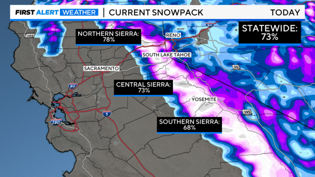
As of Wednesday, Feb. 7, snowpack is now at 73% of average, a 23% boost in just a week.
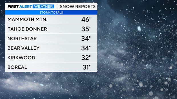
Looking back, the storm brought heavy snow across the Sierra mountain range. Ski resorts reported an average of 2 to 3 feet of fresh snow across their mountain peaks, by far the biggest storm of the season so far.
The snow level throughout Sunday's storm was at or above 5,000 feet most of the time, although snow levels dipped to 3,500 feet first thing Monday morning.
Snow continued Monday and Tuesday with weak waves of energy from the storm as it exited the region, adding another 1-6 inches across the Sierra. Six-day snow totals are around four feet.
This leaves our snowpack in better shape as we get closer to the end of our wet season at the end of the month.
Rain impacts
This storm also brought more wet weather to the valley with most receiving 1-3'' of rain within the last four days.
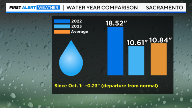
Thanks to excessive wet weather Sacramento has received 10.61'' of rain since Oct. 1. This puts us in a 0.23'' deficit for the 2023 water year, which is much better than it was just a week ago. The amounts are still behind what we picked up during last season.
Thanks to our record-wet winter last year, the state's reservoirs remain above average. Lake Oroville, Shasta and Folsom Lake are all 125 -130% of the historical average as of Feb. 7.
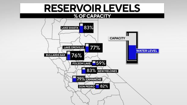
As of Wednesday, Lake Shasta is at 83% of capacity, Lake Oroville is at 77% of capacity and Folsom Lake is at 59% of capacity, but it is a smaller reservoir compared to others.
Water releases from Oroville Dam's main spillway ended Wednesday morning. Reservoirs will be monitored by the Department of Water Resources once new rain and snowmelt arrive to determine if they need to let more water out.
Another system moving in Wednesday will add to the growing snowpack. However this storm will bring milder impacts, it is another colder storm system meaning lower snow levels.
Snowpack is expected to grow another 4 -12'' across the Sierra. Rainfall across the valley and foothills will range from 0.25'' - 1''.
Make sure to stay with the First Alert Weather team for updates on our growing snowpack and reservoir capacity.


