Rain and snow return to Sacramento region with a new storm system, yet impacts will be milder

After back-to-back atmospheric rivers, Northern California is not out of the woods yet of getting more rain and snow this week.
A new storm system moves in Wednesday bringing more rain, snow and wind, yet impacts will be milder.
Wednesday's Storm System
A weak and quick-passing storm system moves through the region Wednesday through Thursday, bringing more rain and wind to the valley and foothills, as well as more Sierra snowfall.
This storm system is moving in from the Pacific Northwest bringing in colder air along with it. This will keep snow levels lower as snow starts to develop.
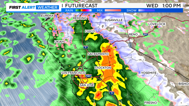
Wednesday will start quiet and cloudy before more rain moves in through the afternoon. By noon - 3 p.m., expect rain to become a bit steadier and heavy at times. It'll be a wet afternoon and evening commute with slick roads across the region.
Rain becomes scattered this evening as this system advances towards the southeast.
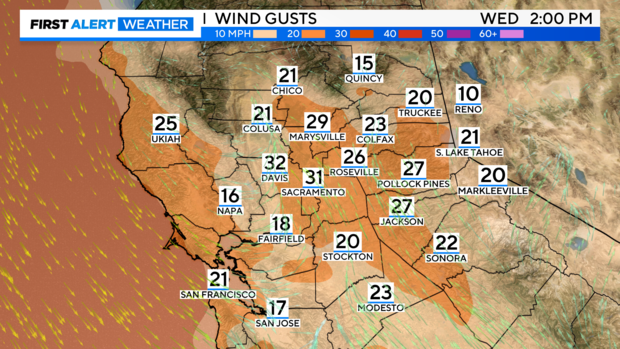
Wind gusts will be close to 30 - 35 mph during the peak of the storm in the middle of the day. We may see more downed tree limbs on trees that were previously damaged in our last storm. But we are not expecting widespread issues.
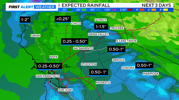
Scattered, light showers continue through early Thursday as this system moves out. Rainfall totals through Thursday morning have trended slightly higher with recent model runs.
Expect 0.25'' to 0.50'' through most of the Valley, with up to 1'' across higher elevations. Some of the hardest hit spots in the Sierra may get up to 1.5'' of rain by Thursday.
Sierra Snow
Snowfall totals have also trended higher with recent model runs.
Snow levels will begin around 4,000 feet and fall to around 3,000 feet early Thursday morning. The heaviest snowfall is expected late Wednesday morning into the afternoon timeframe, before tapering off Thursday morning.
With more snow on the way to the Sierra, travel will be impacted. Expect chain controls and delays and make sure to check road conditions before you travel on the Caltrans website.
A Winter Weather Advisory is in effect Wednesday through Thursday with most snow accumulation above 4,500 feet.
With lowering snow levels, areas such as Pollock Pines and Twain Harte will likely see snow with up to 1-2'' expected.
As you get closer to the pass level, amounts trend higher. 8-12'' of snow will be possible for mountain passes and across higher elevations, especially across the Central Sierra.
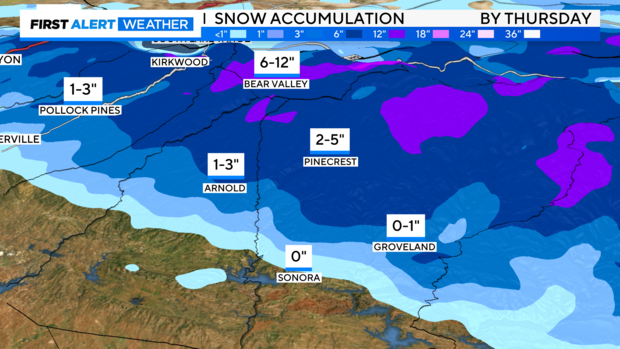
A general 4-8'' of snow is expected for most above 5,000 ft. along I-80 and Highway 50.
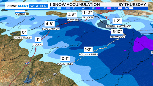
Snow continues through early Thursday before we start to dry out by the afternoon.
The Pattern Looking Ahead
As we look past Thursday, our weather becomes much drier as high pressure starts to build in over the weekend, just in time for Super Bowl weekend!
Saturday and Sunday, expect clearer skies and highs in the low 60s.
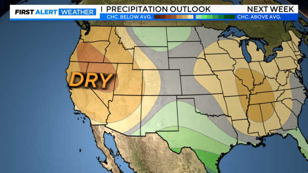
We keep this pattern in place as we get into Valentine's Day week. The start of President's Day weekend looks dry right now but the pattern is changing over the weekend of the 17th-19th.
Make sure to stay with our First Alert Weather team for updates to the forecast.


