First Alert Weather: Rising water levels lead to more evacuation warnings, another major storm on the way
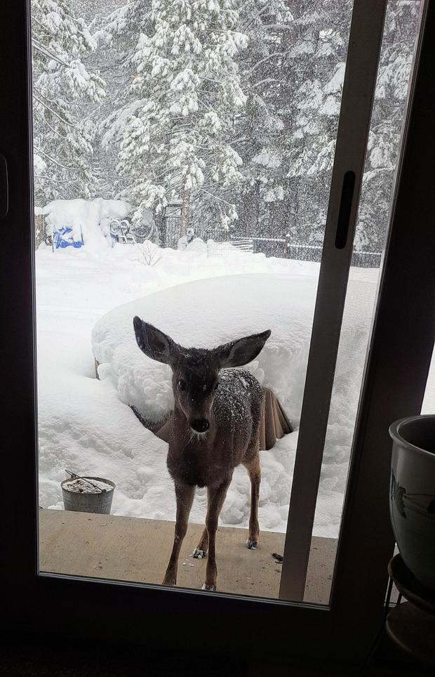
Parts of Northern California are just digging out of the snow and getting their power restored, but another significant system is on the way.
Flash flood warning in effect in Tuolumne County
The Tuolumne County Sheriff's Office said Sunday's flash flood warning has been extended through 9:45 p.m. Sunday.
County officials were monitoring water levels across the area. Just on Saturday, places like Sonora experienced flash flooding due to heavy rain. Streets in Downtown Sonora were submerged in water.
The flash flood warning is also in effect for neighboring Mariposa County.
The county also remains on flood watch through Wednesday with another storm system expected to bring substantial amounts of rain beginning as early as Monday night.
A preview into this week's storm events
STORM DETAILS:
Timing:
Now through Wednesday with the heaviest weather occurring Monday night through Tuesday.
High Wind:
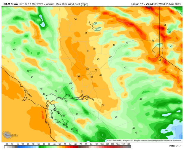
We'll see winds increase Monday evening and Monday night, potentially becoming damaging winds late Monday night through Tuesday morning. Most locations will see gusts around 50 mph but a few spots in the valley may see gusts in excess of 60 mph Tuesday morning. This would result in downed trees and power lines, and scattered power outages are expected across the Greater Sacramento region.
Heavy Rain and Flooding:
Off-and-on showers will develop anytime through Wednesday, with steadier and heavier rain arriving Monday night through Tuesday afternoon.
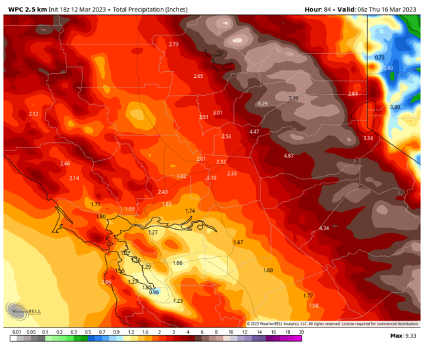
Rainfall totals will vary with a general 1-3" for the Valley and 3-6 inches for the Foothills and Sierra. Localized/ isolated amounts of 7-10" are possible in these locations.
Sierra Snow:
At the Sierra Snow Lab, this is the 4th snowiest winter on record since they built the lab in the 1940s. So far, more than 637 inches measured at the lab.
If you were to melt all of the snow down to liquid water, there is an equivalent to 61.8" of water! That's more than 5 feet of water sitting up in the mountains. Melt it too fast, the flood risk becomes very high. In a way, the thick snowpack is helping us out right now because the snow is able to absorb quite a bit of rain. The last few cold storms produced lots of fluffy snow with low water content, which helps absorb the rain — for now.
The Sierra may see anywhere from 10-20" by Monday morning above 6,500 ft with an additional 1-3 feet expected through Wednesday above 6,500 ft.
Snow levels around 6-7,000 feet Monday will rise to 7,500-8,000 ft Tuesday before falling back to 4-5,000 ft Wednesday morning.
Some of the higher passes and elevations above 8,000 ft, especially south of HWY 50 may receive an additional 8-12 feet of snow between now and Wednesday.
Flooding:
A combination of recent rain, future rain and continued snow melt will cause all rivers and streams to rise well into next week.
The flash flood threat will be greatest in the foothills Monday night and Tuesday.
On Sunday, the Sacramento River at Fremont Weir reached Monitor Stage. This is when water overflows into the Yolo Bypass, which we are already seeing.

The river will continue to rise through much of next week with flood mitigation systems doing their jobs.
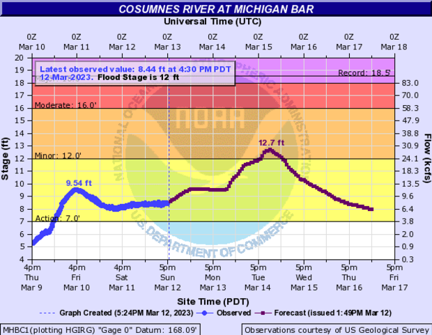
Additionally, the Cosumnes River is expected to go into the flood stage on Tuesday and the Tuolumne River should reach the minor flood stage in Modesto on Wednesday.
Keep in mind, the recent heavy rain from storms in upper Tuolumne County produced several inches of rain and flash flooding. It's very possible the river flood guidance hasn't picked up on this and the river levels for the Tuolumne are under forecast.

Just south, the Merced River at Stevinson is projected to crest at record flood stage Wednesday night. The record for this location is 73.8 ft and the current projection is a crest at 73.9 ft, which is Moderate Flood stage.

Flood Concerns Linger:
Keep in mind, many rivers will rise well into next week. We will get a break later in the week but rivers will still rise. Another atmospheric river event may unfold early next week.
Another gauge to keep in mind later into next week or next weekend is the San Joaquin River at Vernalis (just SE of Tracy) has a 40% probability of going into the danger stage around Tuesday the following week (March 21). It's a way out but this is a high probability when we are a week or more out.

State of Emergency expands to six more California counties
California Gov. Gavin Newsom on Sunday expanded the storm state of emergency to include six more counties: Calaveras, Del Norte, Glenn, Kings, San Benito and San Joaquin.
The state of emergency, which was declared in response to a series of storms set to impact California well into mid-March, was already in place for the following counties:
- Butte, El Dorado, Fresno, Humboldt, Imperial, Inyo, Lake, Mendocino, Merced, Monterey, Napa, Placer, Plumas, Sacramento, San Francisco, San Mateo, Santa Clara, Santa Crus, Stanislaus, Tuolumne, Yuba, Amador, Kern, Los Angeles, Madera, Mariposa, Mono, Nevada, San Bernardino, San Luis Obispo, Santa Barbara, Sierra, Sonoma and Tulare
Evacuation warning issued for communities along San Joaquin River
Several waterways around the region have seen rising water levels after the string of wet weather March has brought, and that includes the San Joaquin River.
The rural areas of Patterson and Grayson, along the west side of the river, are now asked to be ready to move at a moment's notice if the situation gets worse.
The evacuation warning applies to both sides of the river from Grayson Road down to East Marshall Road and Crows Landing Road.
Shelters are available at the Salvation Army Red Shield at 1649 Las Vegas St. in Modesto and the Stanislaus County Fairgrounds at 900 North Broadway in Turlock.
Chain controls dropped on Sierra highways
Chain controls were no longer in place on major Sierra highways.
Caltrans said the restrictions were dropped on Interstate 80 and Highway 50. This comes a day after all Sierra highways were under chain control restrictions as the region was pummeled with heavy snow.
In addition to the chain controls being dropped, Highway 20 was back open to passenger vehicles, though, trucks were being turned around.
More releases from Oroville Dam
The California Department of Water Resources said water releases from the Oroville Dam continued on Sunday.
Officials said it's for flood control protection for downstream communities.
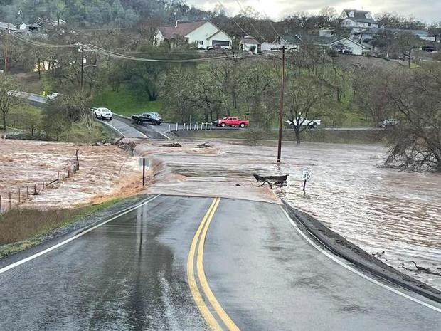
Flooding closes road in Copperopolis
Severe road damage and flooding has closed down Copper Cove Drive in Copperopolis on Sunday.
The closure applies to Copper Cove between Black Creek Drive and Cheyenne Road.
Calaveras County Public Works said it was working to reopen the roadway as soon as possible.
Highway 50 traffic released at Echo Summit
Caltrans said Highway 50 traffic was released after being held at Echo Summit so crews can perform avalanche control work.
The closure lasted for just more than an hour. Chain controls are required on all Sierra highways.
According to Caltrans, wetter snow has made for more problems on the roadways, though, no major spinouts or crashes have occurred.
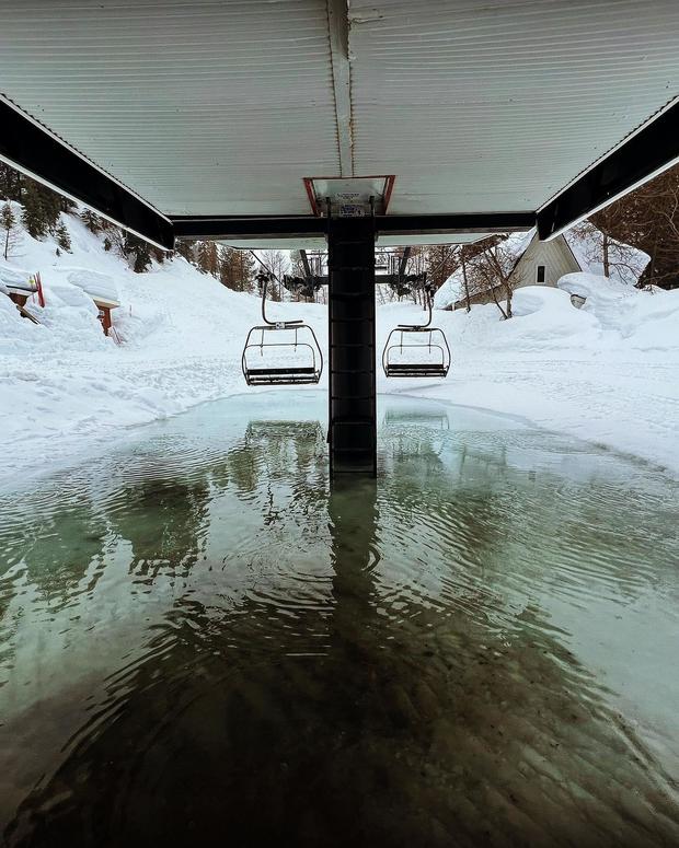
Delayed opening for Heavenly resort
Heavenly Mountain Resort said it is expecting to have a delayed opening Sunday after heavy snow pummeled the Sierra. The resort said "because of the (very) deep, heavy snow and rime ice in particular at our higher elevations, it's going to take more time to clear" lifts and terminal, and to conduct snow safety work.
The resort said it expects to open to guests at 11 a.m. ob both the California and Nevada sides.
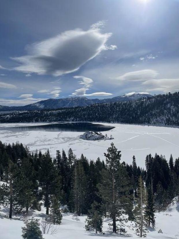
Emerald Bay freezes over
The winter weather has had a powerful effect on the Lake Tahoe area as Emerald Bay has completely frozen over for the first time in decades.
Read more here.
Sonora hit by flash floods, city parks close
There have been extensive reports of roadway flooding in the area of Sonora in Tuolumne County.
The area was one of many that were under a flash flood warning that remains in effect through 6:15 p.m. Parts of Stanislaus and Calaveras counties are also under the warning.
Additionally, the Sonora Police Department said late Saturday afternoon that all city parks were closed due to rising water levels and extreme weather.
Residents are urged to take shelter.
Aside from the severe rain, winds and hail moving through that region, a tornado was also confirmed to touch down near Sonora and Jamestown earlier in the afternoon.
CBS Sacramento's weather team will continue to track the conditions throughout the evening and night.
Flash Flood Warning continues for Tuolumne, Calaveras, Stanislaus County
A flash flood warning continues for parts of Tuolumne, Stanislaus and Calaveras counties and is set to expire at 6:15 p.m.
Severe thunderstorms in the area have produced heavy rains and winds.
The warning includes the following areas: Copperopolis, Jamestown, Sonora, Tuolumne City, Twain Harte, Soulbyville, and Columbia.
Frequent cloud-to-ground lightning strikes were reported in Tuolumne and Calaveras counties, while hail and heavy rain were dumping in Calaveras, too.
Tornado touches down near Sonora amid thunderstorm
A tornado has been confirmed on the ground in Tuolumne County near Jamestown and Sonora.
Everyone in Jamestown, Sonora and surrounding areas is advised to take cover indoors immediately.
A severe thunderstorm warning was also in place for neighboring Calaveras County until 4 p.m.
CBS13's weather team will continue to bring updates as this story progresses.
A tornado warning was issued earlier this afternoon and was expected to expire at 3:15 p.m.
The storm is currently moving east of Highway 108 and the warning does not apply to areas west of Sonora and Jamestown.
Tornado warning issued for local counties
A tornado warning is in effect for Tuolumne and Calaveras counties until 3:15 p.m.
CBS13's weather team is tracking heavy rotation just south of Sonora.
Anyone living in Tuttletown, Jamestown, Sonora, East Sonora Columbia, Chinese Camp, Tuolumne City, and Twain Harte is advised to seek shelter indoors. until the warning passes.
Heavy rain, wind gusts exceeding 45 miles per hour and quarter-sized hail are also expected.
Heavenly Mountain Resort to be closed Saturday
Heavenly Mountain Resort says it will be closed again on Saturday due to the atmospheric river.
Mandatory evacuation order in place in Modesto
According to Stanislaus County officials, an evacuation order has been issued for River Road along the Tuolumne River in Modesto, between South 9th Street and Avon Street.
The order is for any residents and/or businesses in the area (highlighted in red below) on the north side of River Road down to the Tuolumne River.
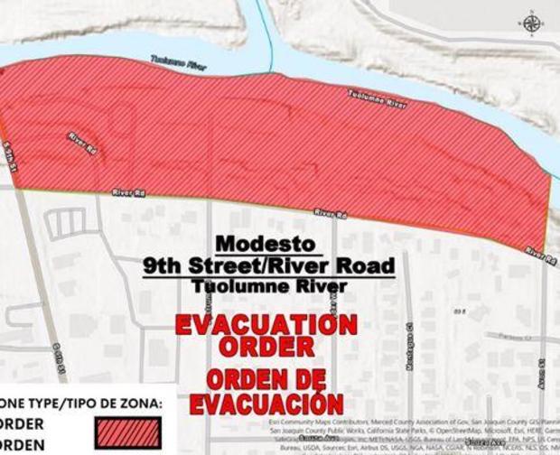
The Tuolumne River is forecasted to rise to 54 feet during the overnight hours. The flood stage on this section of the Tuolumne River is 55 feet. As of 4 p.m., the river was at 50 feet in Modesto. It's expected to hit 53.9 feet on Sunday.

Deputies with the Stanislaus County Sheriff's Office will be contacting affected residents. The county says that if you choose to evacuate, there is a shelter available. Residents may go to the Salvation Army Red Shield at 1649 Las Vegas Street in Modesto. You can also call (209) 552-3880 for information.
What are you seeing in your neighborhood?
If safe to do so, send photos and videos of what you're seeing in your neighborhood Friday morning.
Head to this link to submit your photos: https://bit.ly/3YzgZuh.
Calaveras County road closures
Several roads in Calaveras County are closed due to flooding and other issues, public works officials say.
The following roads are closed:
• Hogan Dam Road at State Route 26 (Valley Springs)
• Hawver Road from Jesus Maria Road to Victory Lane (San Andreas)
• Jesus Maria Road from Hawver Road to Whiskey Slide Road (Mokelumne Hill)
• Salt Spring Valley Road from Felix Drive to Hunt Road (Copperopolis)
• White Road (Valley Springs)
• Baldwin Lane (Valley Springs)
Closure of ski resorts
Significant operational impacts have resulted in the closure of the following ski resorts:
- Heavenly Mountain Resort
- Palisades Tahoe
- Sierra at Tahoe Resort
- Kirkwood Ski Resort
- Dodge Ridge Mountain Resort
- Sugar Bowl Resort
Cosumnes River expected to reach flood stage
The Cosumnes River in Sacramento County is potentially just hours away from flooding. According to the California Nevada River Forecast Center, the river is expected to reach flood stage near Rancho Murieta at 2 p.m. this afternoon.
It's expected to crest at nearly 12.5 feet 2 hours later.
President Biden approves California's emergency declaration
As a result of the emergency conditions resulting from severe winter storms, President Joe Biden has approved California's emergency declaration, and ordered federal assistance to supplement state, tribal, and local response efforts.
This authorizes the Department of Homeland Security and Federal Emergency Management Agency (FEMA) to coordinate all disaster relief efforts, and to provide appropriate assistance for required emergency measures.
Highway 50 back open
Caltrans says traffic has now been released on Highway 50 in the high Sierra and chain controls have been dropped.
Yosemite National Park extended closure
Yosemite National Park remains closed through at least Thursday, March 16.
The additional storms forecast next week could result in further impacts to the park, and conditions will be evaluated on a daily basis. The park will provide an update late next week.
Part of Highway 113 closed
Highway 113 is closed from Main Praire Road to Fry Road in Solano County due to flooding, Caltrans says.
Drivers are being urged to use an alternate route.
Highway 50 closed
Avalanche control has Highway 50 closed from Twin Bridges to Meyers, Caltrans says.
Chain controls also remain in effect from 3 miles east of Kyburz to Meyers.
Due to the high wind, travelers in campers, trailers or permit loads are being urged to stay home for the time being.
Governor Newsom seeking approval for an emergency declaration
Governor Newsom is calling on President Biden to approve an emergency declaration to help the state's storm response.
If approved, it would allow impacted communities to immediately access direct federal assistance, including generators and equipment to clear roads.
The Governor has already proclaimed a state of emergency in 34 counties to support storm response and relief efforts. They include Sacramento, El Dorado, Placer, Stanislaus, Tuolumne, and Nevada counties.
Power outages
The winter storm has impacted in several power outages in the Sacramento region.
SMUD is reporting only 10 outages so far, which have impacted about 400 customers.
PG&E's latest numbers show that thousands of customers in the Sierra and foothills are without power, and the biggest outages are near Nevada City and Grass Valley.
El Dorado County officials urging potential visitors to stay away during storms
El Dorado County officials posted a Facebook message Thursday urging people not to visit areas under local emergency orders during the storms.
The statement read, in part, "Due to the elevated risk of structure collapses and widespread flooding, now is NOT the time to come play in the snow or try to stay in an area that's under a local emergency. We strongly discourage travel into the Basin through this weekend! "
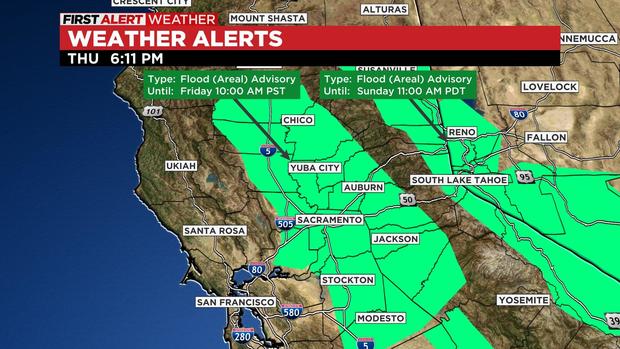
Flood Advisory in effect until 10 am Friday
A Flood Advisory has been issued for the Valley and Foothills -- much of Sacramento and San Joaquin Valleys as well as the ENE Delta through 10 a.m. Friday. Heavy rain is causing ponding of water on the roads and poor drainage flooding.
The advisory area also includes small rivers and streams, low-land areas, culverts, ditches, urban areas, and underpasses, the National Weather Service says.
First Alert Weather: Early evening update
Westbound I-80 back open after crash
Caltrans says affected lanes of Interstate 80 are back open, following a crash involving a big right and a pick-up truck near Eagles Lake.
Chain controls are in effect in both directions from Drum to Truckee.
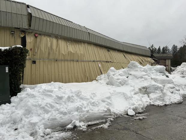
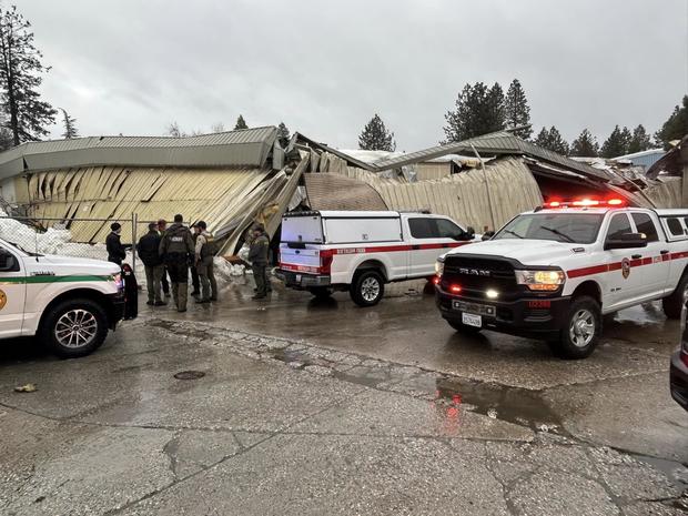
Structure collapses in Grass Valley
On Thursday, a structure collapsed in Grass Valley, presumably under the weight of heavy snow.
Cal Fire, Nevada County Consolidated Fire, Nevada County Sheriff's, and Grass Valley PD responded to the collapse, according to Cal Fire NEU.
The building was confirmed clear of occupants and utilities were secured.
As rain moves into areas that received feet of snow, the weight on rooftops increases, along with the risk for buildings to collapse. Emergency crews in El Dorado County are upstaffed through Monday morning as part of the governor's emergency order, all for winter weather.
Heavenly Mountain Resort to be closed Friday
Heavenly Mountain Resort will be closed on Friday, according to a tweet from the resort. They say the atmospheric river storm system will affect operations through next week.
Sacramento County parks and parkway areas closed due to Nimbus Dam releases
Due to the anticipated releases from Nimbus Dam, the following parks and parkway areas will remain closed until further notice:
- Discovery Park
- Northgate
- Howe River Access
- Watt River Access
- Gristmill Gravel Bar
- Sailor Bar boat launch
On Friday, the county will also be dropping the railings and closing the PCA bridge at Sunrise River Access, according to Sacramento County Regional Parks.
Chain controls on Highway 50
Chain controls are in effect on Highway 50 from Fred's Place (4,900 feet) to Meyers, Caltrans says.
Cal OES prepositioning crews
The Governor's Office of Emergency Services (CAL OES) is preparing for the storm by placing flood-fighting resources in several counties, including Calaveras, Placer, Nevada, and Tuolumne counties, as severe weather hits parts of the state.
The state is also utilizing all possible resources to aid individuals affected by the storm. This includes 43 crews from CAL FIRE, the California Highway Patrol, 4,000 Caltrans workers, and the California Guard, which has prepositioned their high-water vehicles.
The City of South Lake Tahoe on Thursday announced it has activated a virtual Emergency Operations Center (EOC) following the issuance of the Local Emergency Proclamation. Residents can sign up for emergency notifications here: https://www.cityofslt.us/1017/Sign-Up-for-Notifications
Citrus Heights sandbag locations
The city of Citrus Heights is providing sandbags for its residents. Up to 10 bags are available free of charge in the city lobby until 4 p.m.
Sand piles have been placed at:
- C-Bar-C Park (8275 Oak Avenue)
- City Hall parking lot (6360 Fountain Square Drive)
Residents will need to bring their own shovel.
You can find more information here: https://www.citrusheights.net/419/Be-Storm-Ready
Your weather photos & videos
If you see extreme weather in your area, share it with us! Click here to upload your photos or videos. Uploaded submissions will be posted below.
Flood warning on Cosumnes River
Officials have issued a Flood Warning for the Cosumnes River at Michigan Bar.
The water level is expected to rise above flood stage within the next 24 hours.
The warning is in effect through Monday.
Roof concerns
Damage to Echo Ridge Christian school in Nevada City is highlighting the danger of heavy snow loads on roofs.
The K-8th school saw its gymnasium roof collapse.
"Our gym was a critical part of the education program because it was not only used for physical education but also housed the library, music department, chapel, art, and cooking class," said Principal Patti Osborne in a statement.
Notably, while the building had been in use since 1963, officials say the gym had been recently remodeled.
Rain starting in NorCal
The leading edge of the storm is now starting to move into Northern California late Thursday morning.
Coverage and intensity will be increasing over the next few hours.
Cosumnes River forecast
The Cosumnes River is forecasted to peak above flood stage on Friday morning, according to the California Nevada River Forecast Center.
In light of the coming storm, the Sacramento County Office of Emergency Services is reminding the public to be prepared for an evacuation and put together a basic emergency kit.
There are also sandbag stations open for residents in the unincorporated areas of the County:
- Branch Center (3487 Branch Center Rd)
- Orangevale Community Center (6826 Hazel Ave.)
- Westside Park (6555 West 2nd St.)
- Wilton Fire Station (10661 Alta Mesa Road)
- Point Pleasant United Methodist Church (3329 Point Pleasant Road)
Residents are reminded to bring a shovel.
San Joaquin River forecast
Authorities are warning that the San Joaquin River is expected to reach flood monitor stage by Friday afternoon in the Newman area.
Stanislaus County emergency officials issued an evacuation order for the area along River Road in Newman on Thursday. Those notices remain in effect.
What is an atmospheric river?
Confused about what exactly is an "atmospheric river"? As experts say, think of it as a fire hose that aims at, then drenches, a particular region.
For the western US, they account of about 30% to 50% of annual precipitation.
Learn more here, including about some of the historic systems that have hit California: https://www.cbsnews.com/sacramento/news/what-is-an-atmospheric-river/
Park Closure in Fairfield
Parks in Fairfield will be closed starting Thursday, March 9 for a week, including Rockville Park.
This is due to the complete saturation of the soil, overflowing ponds, downed trees blocking multiple trails, and a substantial storm that is expected to bring a forecasted 5+ inches of rain over the next 7 days.
The parks are scheduled for a re-opening on Friday, March 17, after an assessment the day before.
This closure is in line with other nearby regional parks and Solano County parks.
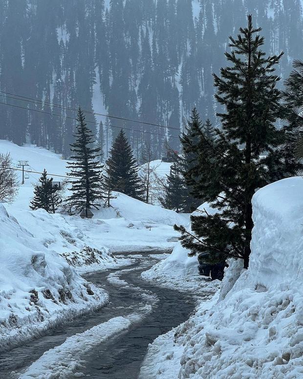
Snow levels to fluctuate
Snow levels are expected to fluctuate over the next few days with this round of storms.
The National Weather Service says, on Thursday, the snow level will start around the 4000-5000' level but will quickly rise by early Friday.
Come the weekend, the snow level is expected to lower again – but not as low as the past cold storms that saw foothill communities get hit.
First Alert Forecast: Action days ahead as atmospheric river sets sights on Northern California
Here's your Wednesday late evening weather forecast.
Flood Watch: What we know about potential flooding in the Sacramento region
More stormy weather is on the way in the form of an atmospheric river. The rain is expected to hit the valley and snowpack in lower-elevation communities, which raises flooding concerns. Nic Merianos shows us the areas facing the greatest threat and when the rain is expected to arrive.
Evacuation order issued for Newman area
An evacuation order has been issued for the Newman area of the San Joaquin River and east of River Road, according to the Stanislaus County Office of Emergency Services.
A map of the evacuation area was posted on the agency's Facebook page.
Officials say an evacuation shelter is being established at Patterson High School.
I-80 back open
California Highway Patrol says chain controls have been dropped on I-80 in the Sierra and the freeway is now open without any restrictions.
Calaveras County sandbag locations
A number of sandbag locations are now stocked in Calaveras County.
Residents can go to one of the following 9 areas for sandbags (limit 10 sandbags per resident and residents need to bring their own shovel):
1. Murphys Fire Station, 37 Jones St.
2. Vista Del Lago Cul-de-sac near Valley Springs Dental, 313 Vista Del Lago
3. Mangili Rd. Cul-de-sac at Valley Springs Sports and Fitness, 145 Mangili Rd.
4. Mountain Ranch Community Center Parking lot next to the Public Safety Substation, 7869 Whiskey Slide Rd.
5. Copperopolis Fire Department, 370 Main St.
6. West Point Volunteer Fire Department, 195 Spink Rd.
7. Glencoe Maintenance Yard, 16151 Hwy 26 (Open from 7:00am to 3:30pm)
8. Jenny Lind Yard 11558 Milton Rd. (Open from 7:00am to 3:30pm)
9. San Andreas Rd Yard, 891 Mt Ranch Rd. (Open from 7:00am to 3:30pm)
Warming zones and sandbags for Stockton residents
In anticipation of severe weather conditions beginning Thursday, Stockton residents can collect free sandbags. Bags and sand are self-fill, self-service and residents are reminded to bring their own shovel.
Sandbags locations:
- Oak Park Little League parking lot - 3545 Alvarado Ave., 95204
- (Former) Van Buskirk Golf Course - 1740 Houston Ave., 95206 (@ S. Fresno Ave.)
Warming zones will also be opened for overnight protection. These will be opened beginning Thursday, with check-out in the morning on Sunday, March 12.
Warming Zones locations:
- Arnold Rue Community Center - 5758 Lorraine Avenue, 95210
- Stribley Community Center - 1760 E. Sonora St., 95205
I-80 traffic being turned
All westbound Interstate 80 traffic is being turned in Truckee due to spinouts over Donner Summit, Caltrans says.
Trucks are also being held on the eastbound side at Applegate.
Sandbags for Fairfield residents
Sandbags and sand are available to Fairfield residents due to expected heavy rains. The sandbags can be picked up from 8:00 a.m. to 4:00 p.m. Wednesday through Friday, March 10 at the following locations:
Sandbags:
- Public Works Corporation Yard at 420 Gregory Street
Sand:
- corner of Pittman and Cordelia Roads
- southeast corner of Allan Witt Park, off Woolner Avenue
For more information, visit www.fairfield.ca.gov/storm.
More school closures
School has now been canceled for the day at both Colfax and Foresthill high schools for the day, the district says.
Some El Dorado County schools closed
Several El Dorado County schools will be closed on Wednesday due to road safety concerns.
The following schools are closed: El Dorado High School, Union Mine High School, Independence High School and Gold Oak Union School District.
Both Ponderosa High School and Oak Ridge High School will start at their regular time, however.
School closures and delays
The weather conditions continue to impact schools' ability to open for classes on Wednesday.
Here are the school districts that have been affected:
Closed
- Black Oak Mine Unified School District
- Grass Valley School District
- Camino Union School District
Delayed
- El Dorado High School
- Union Mine High School
- Independence High School
- Colfax High School
- Foresthill High School
Warm, impactful system on the way
Wednesday is expected to be a wet and snowy day for Northern California – but a more significant storm is coming starting Thursday.
Lingering foothill and mountain snow showers are expected on Wednesday, according to the National Weather Service. The snow levels will be at around the 1500' to 2500' level.
Thursday night is when the widespread read and heavy mountain snow is expected to start.
This storm, an atmospheric river, is expected to bring periods of moderate to heavy rain with high snow levels of 6000' to 8000', due to the relatively warm system. Forecasters warn that this will increase the potential of flooding, especially on Friday.
CBS13's meteorologists are declaring Thursday through Saturday as First Alert Action Days.
Even next week is looking wet, with another warm system expected to hit Northern California starting Monday.


