Philadelphia weather: Rain storms overnight will switch to snow Tuesday morning


PHILADELPHIA (CBS) -- A storm system is moving through the Delaware Valley overnight into Tuesday and will bring snow to parts of the region, especially the Lehigh Valley and Poconos. Philadelphia could get about 2 to 4 inches of snow after rain hits the city hard overnight.
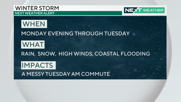
A developing area of low pressure continued to strengthen as it moved across the Tennessee Valley on Monday, and will eventually turn into a snow event for parts of the Delaware Valley on Tuesday, which we've designated a NEXT Weather Alert Day.
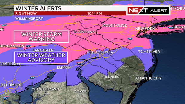
Winter Weather Alerts
A Winter Storm Warning went into effect at midnight and will last until 3 p.m. Tuesday for much of northeastern Pennsylvania and has extended into all of Bucks, Montgomery and Chester Counties and Mercer County in New Jersey.
The Winter Weather Advisory that goes into from 3 a.m. to 3 p.m. on Tuesday now includes all of the I-95 corridor, including New Castle County in Delaware, Salem, Gloucester, Camden and northwest Burlington Counties in New Jersey and Philadelphia.
Storm timing
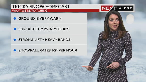
Since temperatures will be well above freezing and close to 50 degrees in the city, this storm will start as an all-rain event for everyone, even in the higher elevations of the Poconos.
Rain will gradually get heavier and steadier in the late evening and Monday night.
By midnight Tuesday, colder air holding back toward the west will eventually start to move in, turning some of the rain to snow by 2 a.m. across the Poconos.
The northernmost areas have the greatest chance for decent snow accumulations through Tuesday morning. In the Lehigh Valley and the Poconos, 8 to 12 inches of snow may accumulate, with the highest totals across Carbon and Monroe Counties.
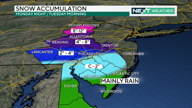
Initially, areas south like Philadelphia were going to get slushy, wet snow.
But now, Philly could get 2 to 4 inches of snow between 7 a.m. and 10 or 11 a.m. before the system moves out.
Areas like Delaware and parts of South Jersey are expected to get a coating to 2 inches of now. Down at the Jersey Shore, it will be mainly wet. The shore will see snow, but it won't stick, Chief Meteorologist Bill Kelly said.
Impacts on the Tuesday morning commute will be felt everywhere, even in the rain-soaked locations. Remember to leave early, slow down and avoid large areas of water on the roadways.
Behind the heaviest precipitation Tuesday morning, we'll see the winds kicking up, gusting between 30 and 40 mph during the afternoon.
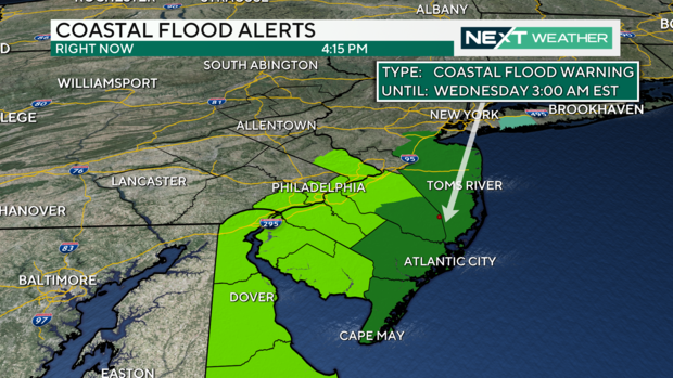
For the shore, moderate coastal flooding is possible with high tide Tuesday morning. Because of this, a Coastal Flood Watch
is in effect for Atlantic and Burlington counties at the shore, with 1 to 2 feet of inundation possible.
Cooler and drier weather is on the menu for Valentine's Day Wednesday, with seasonably cool highs and partly cloudy skies on tap for the rest of the week. Temperatures Wednesday morning will be in the upper 20s to near 30 degrees, which will create some concern for melting snow and residual water freezing on roadways and walkways. By Wednesday afternoon, temperatures will climb back above freezing with highs near 40 degrees.
Your 7-day forecast:
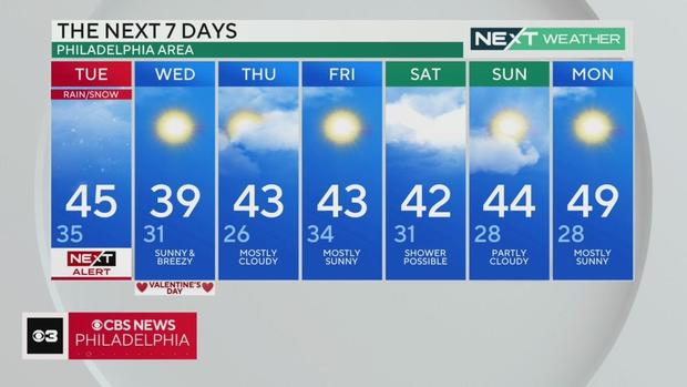
Tuesday: NEXT Weather Alert Day - Wet snow in the morning, ending through the afternoon. High: 45, low of 35.
Wednesday: High of 39, low of 31, sunny and breezy
Thursday: High of 43, low of 26, mostly cloudy
Friday: High of 43, low of 34, mostly sunny
Saturday: High of 42, low of 31, shower possible
Sunday: High of 44, low of 28, partly cloudy
Monday: High of 49, low of 28, mostly sunny


