NEXT Weather: Scattered showers and breezy

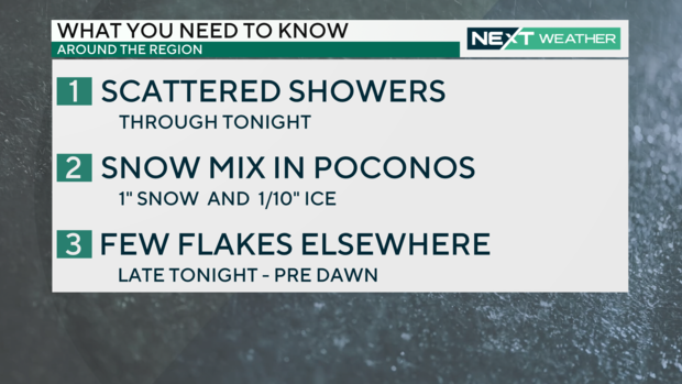
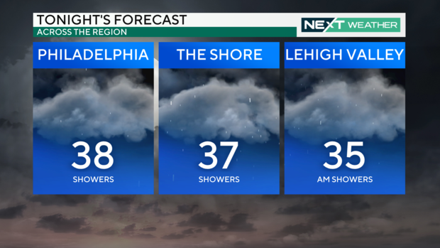
PHILADELPHIA (CBS) -- Sunday is shaping up to be wet and chilly with rains and wind gusts affecting the region. Scattered showers will continue on and off throughout tonight, and a brief wintry mix may appear in some places overnight.
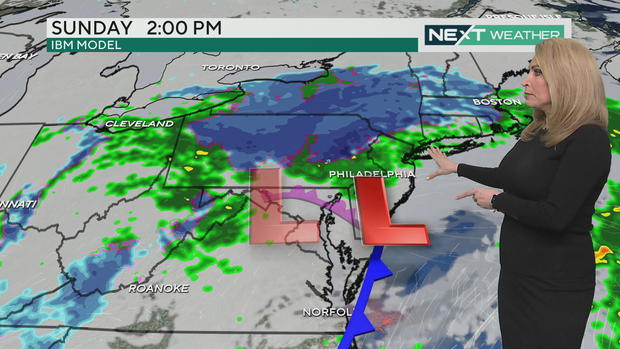
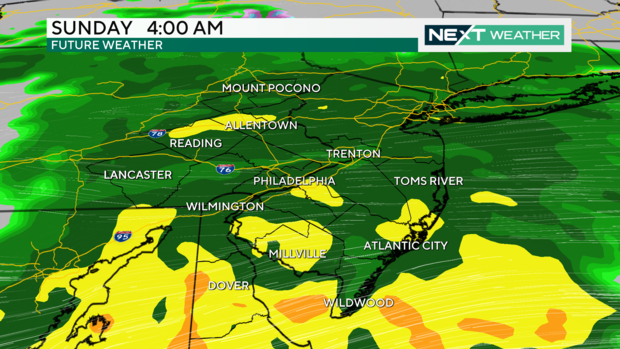
An area of low pressure tracking through the Ohio Valley has brought nearly an inch of widespread rainfall to the entire Philadelphia area.
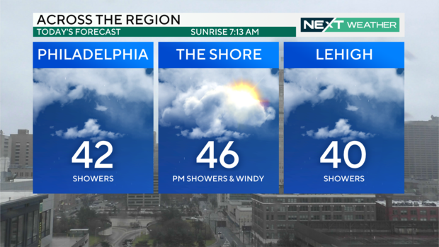
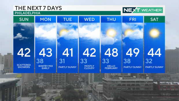
Sunday's forecast across the region shows highs in the low to mid 40s.
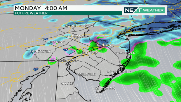
In the afternoon, spotty showers will remain possible across much of the Delaware Valley into South Jersey, but as colder air drops south, snow showers should be expected in the Poconos.
Winds affecting the region are coming out of the north and east and can make the conditions feel 10 degrees colder.
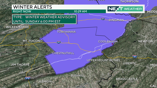
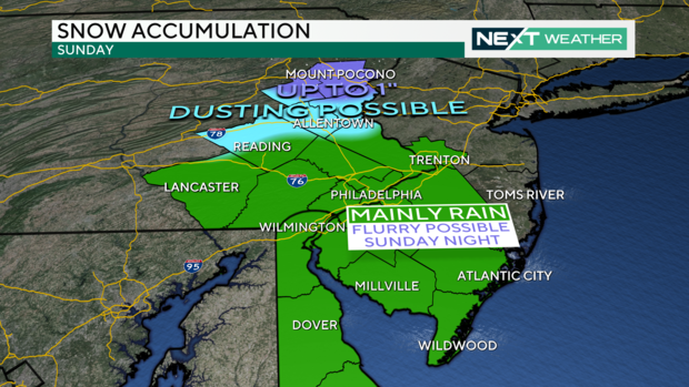
A Winter Weather Advisory is in effect for Monroe County from 1 a.m. to 6 p.m. Sunday where up to 2 inches of snow will be possible through Sunday. This area can also expect the possibility of up to one-tenth of an inch of freezing rain accumulation. Slippery road conditions should be expected Sunday and into Monday morning.
Rainfall totals Sunday are expected to range between 1-1.5 inches which shouldn't be enough to produce widespread flood concerns. Low-lying areas and those with poor drainage may experience some minor flooding, especially across South Jersey and Delaware where rainfall totals could be a little higher.
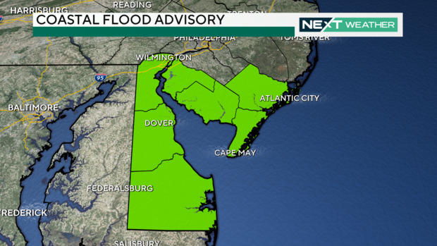
Southeasterly winds ahead of the approaching low pressure system will, however, bring a threat for some coastal flooding along the southern New Jersey coast, Delaware Bay and southern Delaware River.
A Coastal Flood Advisory has been issued for these areas from late Sunday morning until 2 p.m. Up to one-half-foot of inundation above ground level will be possible in low-lying areas near shorelines and tidal waterways. Some roads may need to be closed briefly due to flooding. Do not drive around barricades or through water of unknown depth.
As the low pressure system transitions east of the region, most of the precipitation will move out as drier and colder conditions rush in. The arrival of the colder air on the heels of the departing precipitation Sunday evening may be enough to mix in a few snowflakes with the rainfall, but there isn't expected to be enough to result in any accumulations in the Delaware Valley. In addition to snowfall of up to 1 inch in the Poconos, a light and brief dusting of snow in portions of the Lehigh Valley cannot be completely ruled out.
Sunday night's forecast shows temperatures dipping into the 30s across the region.
Most of the precipitation will clear out of the region Monday morning as temperatures generally remain above freezing in the middle 30s. Some roadways may remain a little wet, but breezy conditions and drier air moving into the region should help dry the roads pretty quickly into the afternoon.
The weather for the upcoming week will then be relatively benign with seasonable conditions keeping high temperatures in the low-middle 40s and overnight low temperatures in the low and middle 30s.
Continue to check back with the CBS Philadelphia Next Weather Team as conditions evolve.
Get the latest weather info on the CBS News Philadelphia app.


