NEXT Weather: Dangerous arctic blast, chances for accumulating snow this week

PHILADELPHIA (CBS) -- A NEXT Weather Alert is in effect Monday through Sunday as a dangerous stretch of cold and chances for accumulating snow move into the region this week.
Sunday afternoon, a series of Snow Squall Warnings expired after brief rounds of snow and gusty winds pushed across southeastern Pennsylvania.
While some areas in the mountains may get some light accumulations, the temperatures will rise into the mid-30s in the city, squashing any chances of anything significant.
That said, grassy surfaces and parked cars may pick up a coating to perhaps half an inch. Any little amounts we do get will be gone by the mid-afternoon, with some sun returning along with those slightly milder temperatures.
Beyond that, expect generally partly cloudy skies and gusty winds for the remainder of the day. High temperatures Sunday will reach around 43 degrees before dropping back into the 20s overnight.
Tracking more snow
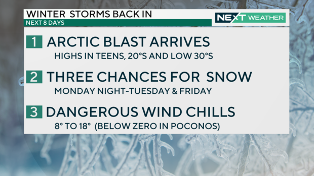
A lobe of extreme cold has descended from the Arctic Circle across the Plains and Midwest. The cold air from this system extends as far south as Texas, with some temperatures dipping as low as -43 degrees, and will slowly spread eastward.
Locally we won't see temperatures that cold, but we will be hit with below-freezing temps and dangerous wind chills.
With this frigid air in place, several storm systems will bring Philly the first chance of accumulating snow in two years.
Timing
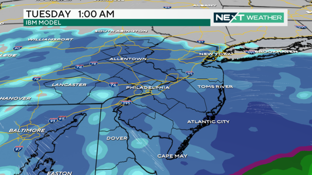
Snow moves in around 10 p.m. Monday and continues overnight until around noon Tuesday, though the track and timing could still change slightly before Monday night.
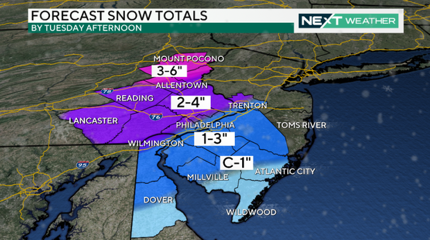
Currently, 1-3 inches is possible in the city, with a dusting at the shore and closer to 3-5 inches in the Poconos.
Some snow could continue to fall during the early Tuesday commute and create slippery road conditions.
Dangerously cold temperatures
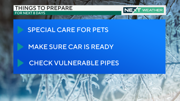
An arctic front moves in tonight, bringing a deep freeze that will stay with us through next Sunday. This will be our coldest stretch in several years.
Temperatures dip into the teens and 20s tonight and Monday through Thursday temps will likely remain below freezing, for about 96 hours. Wind chills will be in the teens and single digits this week and below zero in the Poconos.
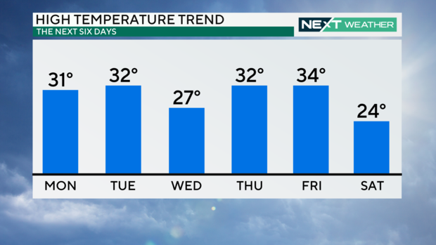
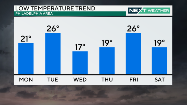
The coldest days are Wednesday and Saturday with high temperatures of 23 and 27, and lows of 16 and 18, respectively.
More late-week snow
Another round of snow is possible Thursday night through Friday evening, and this storm could drop several inches of snow.
The timing and track may change, which would impact snow totals. The CBS Philadelphia NEXT Weather team will be following this storm all week.
7-day forecast:
Sunday: High of 43, brief snow shower
Monday: High of 32, low of 21, very cold, overnight snow possible
Tuesday: High of 34, low of 26, chance for snow
Wednesday: High of 28, low of 17, dangerous cold
Thursday: High of 35, low of 19, still cold
Friday: High of 35, low of 28, still cold!
Saturday: High of 28, low of 23, chance for snow
Get the latest weather info on the CBS News Philadelphia app.


