NEXT Weather: Rising temps before storms arrive

PHILADELPHIA (CBS) -- We're all over the place when it comes to temperatures the next few days.
Friday started off cool, but we're looking at temperatures in the 60s this afternoon.
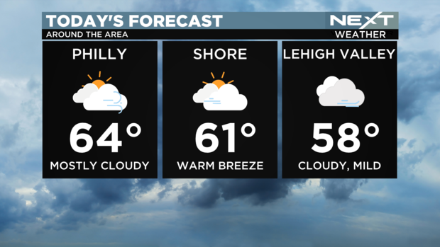
We'll will warm up through the day, with temperatures reaching the 60s, and it'll be cloudy.
Friday evening, we might see some showers in the Lehigh Valley, but those will break up quickly.
April could start off a little on the loud side.
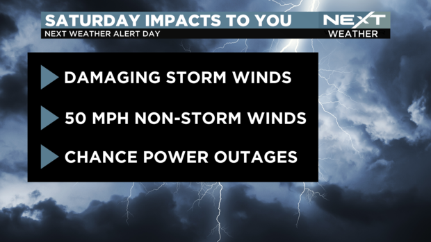
Saturday is a NEXT Weather Alert Day
We may see a wind advisory with gusts of 50 mph possible throughout Saturday, but the biggest impacts could come from evening storms.
A first batch of rain moves through the Delaware Valley between 12 a.m. and 3 a.m., and another wave will arrive around 7 a.m.
A few isolated rumbles of thunder are possible and morning temperatures will be near 60, which is the normal low for early June.
On-and-off rain is likely through 10 or 11 a.m. Saturday, with locally heavy showers and a rumble of thunder possible.
But mid-day break will influence what we see Saturday evening.
The more sun we get in that time, that could percolate the atmosphere, creating instability and a greater chance of stronger storms as a cold front approaches.
By Saturday evening, we could see damaging winds.
There's potential for power outages with those high winds.


