NEXT Weather major storm approaching Delaware Valley
PHILADELPHIA (CBS) -- Early Friday afternoon, a strong storm system will arrive from the desert southwest. Precipitation will be light through the afternoon but heavy rain develops later in the evening.
We have wet snowflakes coming down around Penn Valley but nothing is sticking. Viewers told us there's nothing yet in Maple Shade, N.J. but it's cold and rain is coming down. Another viewer said snowflakes were coming down in the Andalusia area and a viewer in central Delaware said it was all rain in the area.
This same storm has fueled severe storms with potentially violent tornadoes across the southern plains. We are not expecting severe weather here in the Delaware Valley, although a few rumbles of thunder are possible. What type of precipitation you see will depend on where you live.
Between 10:00 a.m. and noon, light showers will start in Delaware and parts of South Jersey.
Between 1:00 p.m. and 3:00 p.m., light scattered showers will spread across Philadelphia, the Pennsylvania suburbs, South Jersey and the Shore.
Between noon and 2:00 p.m., a mix of snow and sleet will develop in the Lehigh Valley, Berks County and the Poconos. Light ice accumulations up to 1/10 of inch are possible in the Poconos.
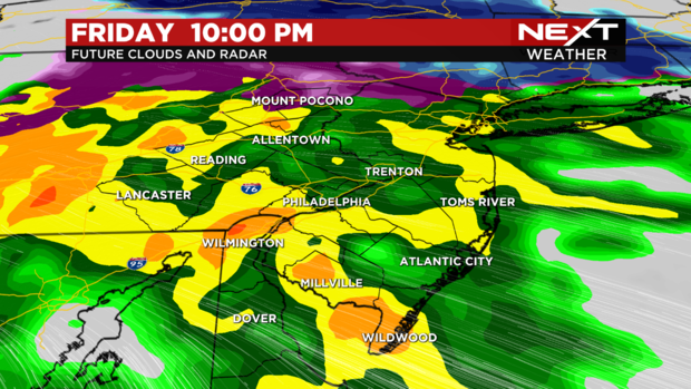
Our radar shows fairly light rain after 4:30 p.m. and a few snowflakes mixed mostly in the far west and northwest zones. The heaviest rain is still to come as it's expected to get really windy as the weather moves from the midwest.
This initial shower and sleet activity will continue into the early evening with a few lulls in the rain.
Between 8:00 p.m. and 10:00 p.m., heavy rain with isolated thunderstorms spreads across the entire area and will continue overnight.
Don't expect much strong to severe weather but by 7 p.m., there will still be some showers in the area but starts to become widespread with rain. Around 8-9 p.m., rain is projected to hit hard near Trenton, Allentown and in addition to that, we could have plenty of thunder and lightning.
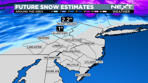
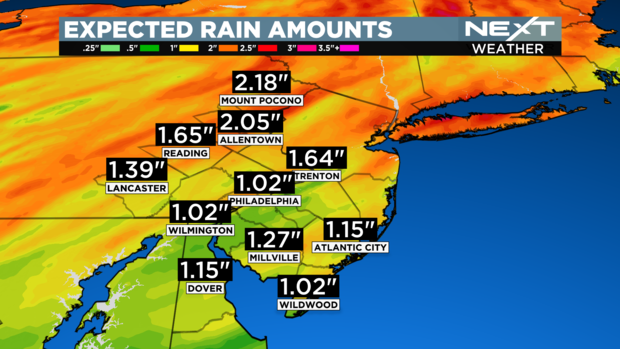
Rainfall totals will approach 1-2 inches with slightly higher amounts in some areas. A mix of snow and sleet could total 1-3 inches in the Poconos.
When you leave the house Friday morning, carry the umbrella, you will need it later in the day.
Your morning commute will be dry but the evening commute will be wet in some places. If you are traveling around the area Friday night, be aware of ponding on the roads with localized flooding possible by late Friday night.
Winds, flooding: what to expect
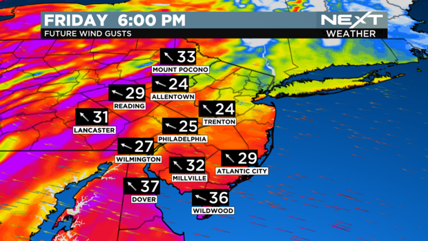
Winds will also increase Friday night with gusts above 35 mph in Philadelphia and greater than 45 mph down the Shore.
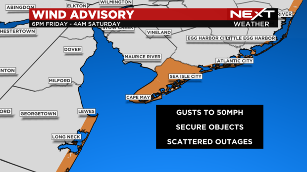
A wind advisory is in place for Cape May County and coastal areas of the Jersey Shore and Delaware beaches.
There is also a coastal flood advisory in place across Pennsylvania, New Jersey and Delaware.
By Saturday morning, all showers have ended and skies will be mostly cloudy clearing to some afternoon sun.


