Hurricane Idalia path and timeline: Maps show where the storm is heading and when
Update: Hurricane Idalia made landfall Wednesday morning. Read the latest here.
Hurricane Idalia briefly strengthened into an extremely dangerous Category 4 over the Gulf of Mexico early Wednesday but then weakened slightly back to a Category 3 before making landfall at Keaton Beach in the Big Bend region of Florida, the National Hurricane Center said. It warned the storm was bringing "catastrophic" storm surge and "destructive winds."
The center emphasized that the "change in wind speed does not diminish the threat of catastrophic storm surge and damaging winds," the consequences of which may be exacerbated by a concurrent "king tide."
Idalia was downgraded to a Category 1 and then to a tropical storm later in the day as its wind speeds declined. Hurricane warnings were issued for parts of Georgia and South Carolina as Idalia continued to travel along its projected path up the southeast coast of the U.S., while Florida communities grappled with infrastructure damage, shuttered airports and widespread power outages.
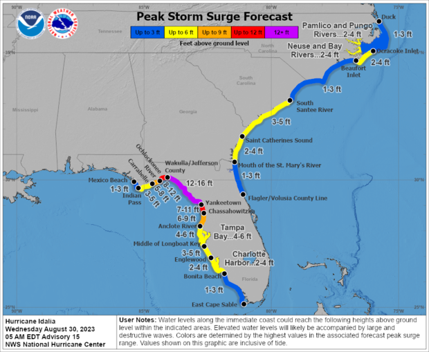
Storm surge in some areas was expected to reach 16 feet.
"That level of storm surge is life threatening," Florida Gov. Ron DeSantis said at an early morning briefing, adding, "There will be impacts far behind the eye wall, and those will extend to places like Tallahassee" and other parts of northeast Florida.
The storm made landfall with maximum sustained winds of 125 miles per hour. Wind speeds of 111 mph to 129 mph make it a Category 3, which is considered a major storm capable of "devastating damage," the hurricane center says.
"In this part of Florida, particularly the Big Bend coast, we haven't seen a hurricane landfall of this intensity in many, many, many years," Michael Brennan, director of the National Hurricane Center, told "CBS Mornings" on Wednesday.
He said the region's shallow continental shelf adds to the storm's impact, with the hurricane's circulation pushing water inland, which is leading to catastrophic storm surge.
"We're gonna see, you know, not just the storm surge but potential for damaging winds extending well inland all the way across portions of north Florida, into southern Georgia, into places like Savannah, Hilton Head," Brennan said. "We have hurricane warnings in effect for the fast-moving hurricane. It's going to bring those winds really far inland today and tonight."
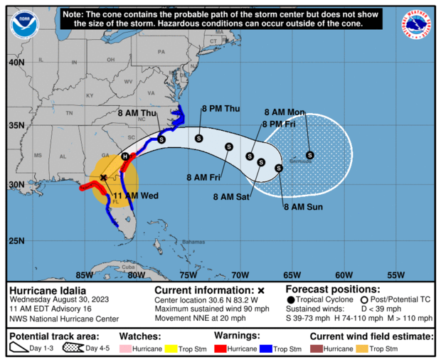
Idalia's path was expected to impact a wide central portion of Florida before moving along the Georgia and Carolina coastline Wednesday into Thursday.
At a briefing Tuesday evening, Gov. DeSantis urged people in the evacuation zone to leave immediately.
"If you stay hunkered down tonight, it's going to be too nasty tomorrow morning to be able to do it," he said.
"If you do choose to stay in one of the evacuation zones, first responders will not be able to get you until after the storm has passed."
Hurricane Idalia's location and warnings
Idalia spent several days churning toward the Florida coast from the Gulf of Mexico. As the storm intensified, meteorologists warned that it could bring "catastrophic" storm surge and "destructive winds" to the Big Bend region as it moved over land.
"While Idalia should weaken after landfall," the center continued, "it is likely to still be a hurricane while moving across southern Georgia, and near the coast of Georgia or southern South Carolina late today. Idalia should emerge off the southeastern United States coast early on Thursday and move eastward through late week."
On Facebook early Wednesday, Cedar Key resident Michael Presley Bobbitt posted video of water coming up to his home and said, "The water just keeps coming. Pray for Cedar Key."
CBS News senior weather and climate producer David Parkinson noted Tuesday that the massive storm surge expected to accompany Idalia's arrival on land "is the primary threat with this storm."
"There is likely a level of people being caught off guard farther south as the storm is just skirting by," he said. "The storm surge may go as far as US19 inland, so there's a lot of area covered by that, even if the coast isn't populated like near Naples. No one alive in these areas has seen flooding this bad there if it hits max potential."
Gulf Coast communities were under a range of severe weather advisories, from hurricane and tropical storm warnings and watches to storm surge warnings and watches, but the National Weather Service Tallahassee said the tropical storm and hurricane warnings had been canceled as of about 5 p.m. Wednesday, while concerns remained about "lingering coastal flooding, especially at high tides."
The hurricane center had warned that storm surge could get as high as 16 feet in the area from the Wakulla/Jefferson County line in Florida and as high as 6 feet in Tampa Bay.
DeSantis declared a state of emergency in 49 counties and the state mobilized more than 5,500 National Guard members to respond to the storm. Between 30,000 and 40,000 electricity workers would be on hand to restore power after the storm hits, the governor said.
Evacuation orders or recommendations were posted in 28 counties and dozens of school districts across Florida had suspended classes.
Meanwhile, Hurricane Franklin, to the east over the Atlantic, was churning on a track that's expected to keep it off the East Coast.
Franklin was a major Category 3 hurricane early Wednesday packing 115 mph sustained winds and bringing "life-threatening surf and rip currents" along the East Coast and was forecast to bring tropical storm conditions to Bermuda starting later on Wednesday, the hurricane center said.
Meteorologists rate hurricanes according to the Saffir-Simpson Wind Scale, categorizing storms that fall within Categories 3, 4 or 5 as "major" hurricanes capable of causing "significant loss of life and damage," according to the National Hurricane Center. The categories are based on a hurricane's maximum sustained wind speeds.
Where did Hurricane Idalia hit?
Idalia made landfall Wednesday morning in the Big Bend region, which is where the Florida peninsula meets the panhandle. Storm surge along the coast there was forecast to reach 12 to 16 feet, worsening through the day as the tide rises.
Storm surge is a rise in water levels caused by hurricane-force winds that push water toward shore and over areas of land that are normally dry, according to the National Oceanic and Atmospheric Administration. This phenomenon is considered the greatest threat to life during a hurricane.
In Crystal River, north of Tampa, city manager Doug Baber warned about the threat of storm surge — the worst of which isn't expected until high tide later on Wednesday.
"The surge is going to be pushing in later today. The biggest part of the surge is going to be around 4:30 ... due to the high tide," he told "CBS Mornings" Wednesday, warning people against having a false sense of confidence that they can go out on the roads before the surge arrives.
Forecasters also warned that "areas of flash and urban flooding, some of which may be locally significant, are expected across portions of the west coast of Florida, the Florida Panhandle, and southern Georgia Tuesday into Wednesday, spreading into portions of the eastern Carolinas Wednesday into Thursday."
Ahead of the storm, officials had urged people living in low-lying coastal areas along the Gulf, many of whom were under evacuation notices, to move to higher ground.
"You run from the water and you hide from the wind. If you're there in that storm surge, you're putting your life in jeopardy when it gets to be that high," Gov. DeSantis said.
A major hurricane has never entered the Apalachee Bay, located just south of Tallahassee where the Florida peninsula meets the mainland U.S., said the city's National Weather Service branch, which called the potential arrival of Idalia "unprecedented."
"Hurricane Idalia will likely be an unprecedented event for many locations in the Florida Big Bend. Looking back through recorded history, NO major hurricanes have ever moved through the Apalachee Bay. When you try to compare this storm to others, DON'T. No one has seen this," reads a message posed to the front page of the website for NWS Tallahassee.
As Idalia intensified and approached on Tuesday, DeSantis told Florida residents: "There's a huge number of counties that are going to feel impacts from this." He referenced updated computer models from the National Hurricane Center that indicated the storm could impact inland areas as well, including Columbia County and Madison County, which sit near Florida's border with Georgia, between Tallahassee and Jacksonville.
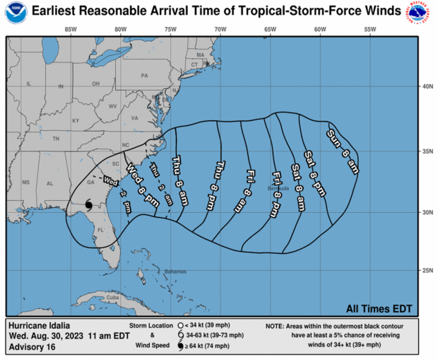
A hurricane warning means that hurricane conditions are expected somewhere within the boundaries of the warning area, while a hurricane watch means those conditions are possible, according to the National Hurricane Center. Forecasters urge people in areas under hurricane warnings to prepare for the onset of conditions within the next 12 to 24 hours. People living in areas placed under storm surge watches should prepare for the "possibility of life-threatening inundation, from rising water moving inland from the coastline" over the next 48 hours, the hurricane center said.
There is a possibility of strong and potentially damaging wind gusts from Idalia that could "extend well eastward from the storm's center" once it makes landfall in Florida, the weather service said. Meteorologists added that torrential downpours could also happen in eastern parts of the state, which may be subject to increasing tornado threats as well.
Map of Hurricane Idalia's projected path
Meteorologists forecast a northeastern path for Idalia, tracking over the Gulf of Mexico toward the northwest coast of Florida throughout Tuesday and into Wednesday.
After making landfall along Florida's Gulf Coast, Idalia continued across northern Florida and coastal Georgia and into South Carolina by Wednesday night. It was expected to continue moving up the coast of the Carolinas through Thursday before moving out into the Atlantic, decreasing in strength as it travels.
Will Idalia and Franklin hit Florida at the same time?
Hurricane Franklin is not expected to hit Florida, but it will cause rough surf conditions and rip currents. Officials haven't issued any forecasts suggesting that Franklin will make landfall anywhere along the East Coast.
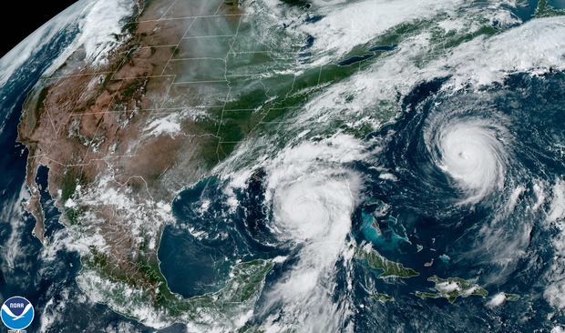
An incoming "long-period swell" in the Atlantic caused by Hurricane Franklin will make the coast susceptible to "high seas, rough surf, an increase in life-threatening rip currents, and beach erosion during high tides during Tuesday and Wednesday," according to the hurricane center.