First fall front to bring big changes this weekend

PHILADELPHIA (CBS) -- All good things must come to an end and the nice stretch of weather this past week has certainly been a good thing, but now that will come to an end as well.
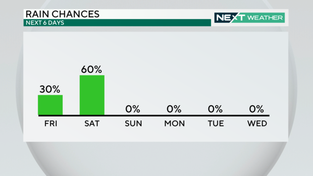
A cold front sweeping across the country will bring back a small chance of rain Friday into Saturday before it ushers in much cooler temperatures through the second half of the weekend into most of next week.
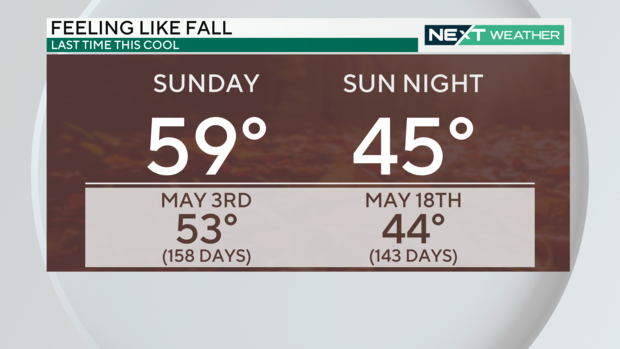
High temperatures Sunday afternoon will struggle to climb out of the 50s with low temperatures Sunday night dropping into the low and middle 40s. This will be the coolest temperatures the region has had since the middle of May. The last time the Philadelphia area had low temperatures in the middle 40s was on May 18th when the low temperature was 44 degrees.
A relatively warm and humid southerly flow ahead of the approaching cold front will keep temperatures Friday in the mid-upper 70s despite mostly cloudy skies. In addition to increasing clouds and a little more humidity on Friday there will be a small chance for some spotty showers through the day.
The chance of rain will increase even more Friday night through the first half of the day on Saturday as the cold front approaches the region from the west. The low pressure system associated with the cold front will strengthen into Saturday as well as it merges with a weakening tropical storm (Phillipe) as it tracks north well east of our coast. This merger of low pressure systems will actually cause the majority of the rain associated with the cold front to regenerate farther north and east toward New England.
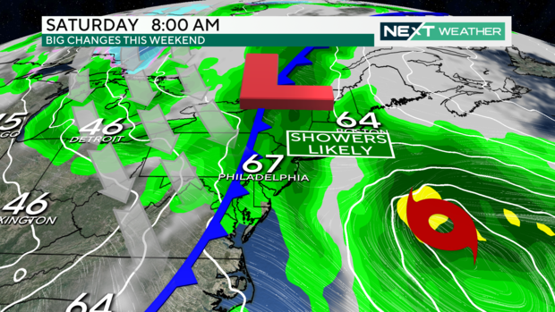
Scattered showers and a few thunderstorms are still expected through the first half of the day on Saturday ahead of the cold front, but once the cold front sweeps through the chance of rain should begin to taper off quite a bit. Temperatures ahead of the cold front on Saturday will manage to climb into the mid-upper 60s, but once the front pushes east through midday temperatures aren't expected to climb much more. In fact, by the time we reach what is typically the warmest part of the day temperatures may actually already begin cooling as the winds shift to the northwest and much cooler air rushes in.
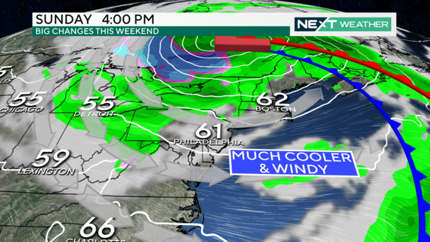
Temperatures will then take a tumble Saturday night with overnight low temperatures settling in the mid-upper 40s Sunday morning. The cooler air will continue to rush into the area riding a blustery northwesterly wind gusting up to 30 mph Sunday afternoon. High temperatures Sunday will make a run at 60 degrees, but most of the day will be spent in the 50s under partly sunny skies.
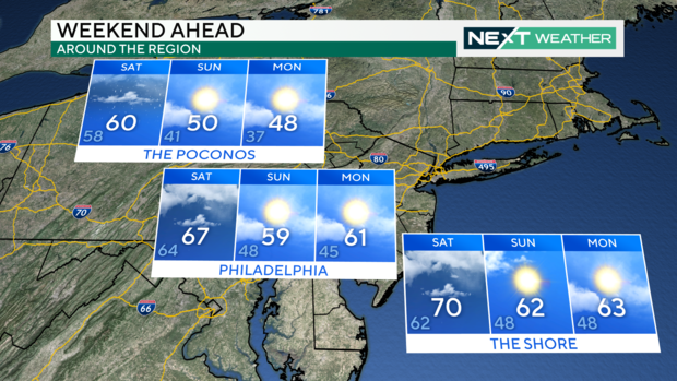
The coldest temperatures will arrive Sunday night into Monday morning when temperatures cool into the low and middle 40s across most of the area. Locations in the Poconos will likely see some places dip into the upper 30s.
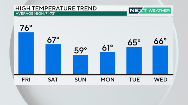
Monday will feature another cool day with high temperatures only around 60 degrees, roughly 10 degrees cooler than normal. The warmth will then gradually build through the week with highs expected to return to near normal by Thursday.


