A critical moment for Tropical Storm Dorian is just hours away
Tropical Storm Dorian poses the first big threat of the hurricane season to the Caribbean and Florida. While this storm is not expected to become a behemoth like Hurricane Maria or Irma, there is a chance this could be a significant system when it reaches Florida this weekend. The future of Dorian largely hinges on one key factor called the Mona Passage. This 80-mile wide ocean corridor, which sits between the islands of Hispañiola and Puerto Rico, will determine if Dorian dissipates or perseveres.
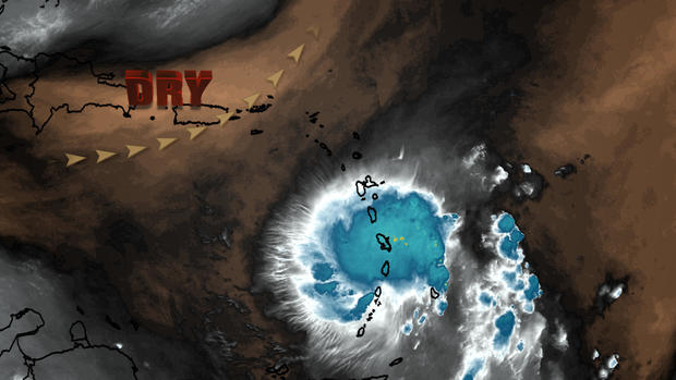
Dorian is now located in the Caribbean, a small storm surrounded by a hostile environment of abundant dry air.
As seen in the graphic below, it is likely the small size of Dorian has helped to insulate the storm, in a cocoon of sorts, from the outside environment of not only dry air but also strong winds ahead of the system, which would otherwise tear Dorian apart.
Given the system's tenacity so far, it seems Dorian will survive its track northwestward toward Puerto Rico. The small size of the storm may even allow it to strengthen some, as the official forecast from the National Hurricane Center calls for, through Wednesday.
It seems virtually certain that a strong tropical storm or even low-end hurricane will buffet Puerto Rico and the Dominican Republic Wednesday through Thursday. That means wind gusts near hurricane force (74 mph or greater) and flooding rains up to 10 inches are expected.
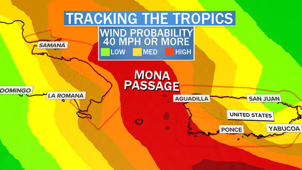
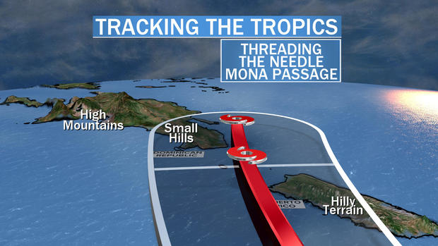
Regardless of impact, Wednesday night is a critical moment for the future of Dorian and its eventual impact on Florida. At that time, the core of Dorian will either move over Puerto Rico, over the Dominican Republic, or in between the two, through the narrow waters of the Mona Passage. This seemingly subtle detail is critical.
The consensus forecast of both the National Hurricane Center and the various computer models shows a most likely track in between the two islands, right through the 80-mile-wide Mona Passage.
If the core of Dorian moves slightly west of there, over the center of Haiti and the Dominican Republic, it will encounter towering mountainous terrain with elevations over 5,000 feet. That would destroy the storm's structure and circulation, crippling the system as it enters the Bahamas. It would have a hard time putting the pieces back together and strengthening before its arrival this weekend in Florida.
However, if Dorian's core threads the needle between the islands and passes over, or near, the narrow Mona Passage, then the storm's core and circulation will remain structurally sound. In this scenario, the storm would be able to take advantage of the very warm water north of Puerto Rico, in the Turks & Caicos Islands and Bahamas, to potentially reintensify.
A track over the island of Puerto Rico, to the east of the consensus forecast, would yield a scenario somewhere in the middle, where Dorians' core would be weakened but not incapacitated.
Once Dorian moves past Puerto Rico, Haiti and the Dominican Republic — the islands known as the Greater Antilles — on Thursday, it will then have a somewhat clear path to strengthen. The computer models seem to indicate a decent environment for strengthening with lessening environmental winds (weaker wind shear) likely allowing Dorian to get better organized.
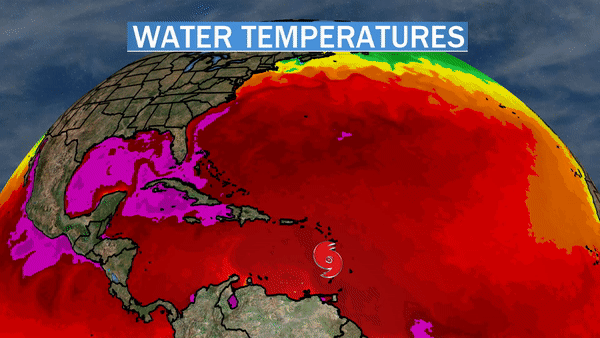
Assuming Dorian's core and circulation remain intact, it will have only sporadic landmasses, the islands of the Bahamas, to contend with before it reaches Florida. These islands are not large enough to weaken the storm. However, the very warm 84- to 88-degree Fahrenheit water in the Bahamas can have a significant impact. This water has the potential to act as high-octane fuel, possibly turbo-charging the tropical system between Thursday and Saturday.
By Saturday, Dorian will enter another critical zone called the Gulf Stream. The Gulf Stream is a narrow channel of deep and very warm waters east of Florida. Storms like Hurricane Andrew in 1992 and Katrina in 2005 have been known to intensify quickly in this stretch. While not every storm does intensify in the Gulf Stream, it is a key aspect in determining whether Florida will be facing a weakened tropical storm or a strengthening hurricane at landfall.
While it's too early to know how strong the storm will be or where along the east coast of Florida the system will make landfall, the key factors to watch over the coming days are clear. The most important of these factors will be apparent shortly as the storm decides if it will ride the Mona Passage. If it does — watch out.
Now is the time to prepare for the possibility of a hurricane making landfall this weekend somewhere along Florida's east coast. That means freshening up your hurricane safety kit right now.