Blizzard could dump 4 feet of lake-effect snow on upstate New York
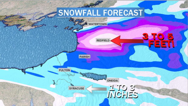
A "fire hose" of fierce snowfall is aimed right at a few towns in upstate New York — complete with 60 mph wind gust and whiteout blizzard conditions. Parts of the Tug Hill Plateau, just north of Syracuse, will see 4 feet of snow pile up by Friday night.
But drive just down the road and 50 inches turns to mere flurries in within 15 miles. Welcome to lake-effect snow country, where several feet of snow in just a couple of days is a seasonal occurrence.
A winter storm which brought nothing more than a modest snowfall of just a few inches to the Ohio Valley, Great Lakes and Northeast is now on its way out. And while the snow tapers down for most, an epic blizzard is just starting for towns north of Syracuse.
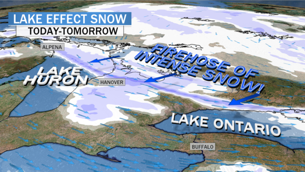
In the wake of the departing storm, cold winds are howling across the Great Lakes from the west-northwest with gusts from 40-70 mph. These cold winds are picking up moisture from the lakes and dumping snow downwind.
Blizzard warnings are in effect through Friday afternoon for the towns of Watertown, Oswego and Fulton, New York.
The National Weather Service is forecasting 3 to 4 feet of snow in the heaviest band, with gusts to 60 mph. The snow will taper off Friday night and Saturday, with some towns, perhaps Redfield, likely to get over 50 inches of snow.
The intensity of any lake-effect snowstorm depends on the contrast between the air temperature and water temperature. The effect is heightened right now by very mild and mostly ice-free Great Lakes waters, thanks to a very warm winter so far.
As a result, water temperatures in Lake Ontario are near 40 degrees Fahrenheit, while temperatures in the clouds are near zero. This 40-degree temperature contrast, combined with strong and steady winds, is enhancing the evaporation of moisture from the Great Lakes, spiking the snow-making process in the clouds above.
The steady, relatively straight winds allow the lake-effect snow machine to consolidate into a narrow plume, only 15 miles across but 700 miles long, picking up moisture from Lake Superior, Lake Huron and Lake Ontario. Loaded with three lakes' worth of moisture, that "fire hose" will then blast an area just east of Lake Ontario called the Tug Hill Plateau.
That alone would generate intense, whiteout snowfall rates. But Tug Hill has one more trick up its sleeve: It's a hill. Reaching 2,000 feet above sea level, the hill itself lifts the winds which are bombarding it. That forces the air vertically upward and causes the clouds to boil up, further intensifying snowfall rates. At times, snowfall rates from this event will top 5 inches an hour.
Because of this confluence of factors, the Tug Hill Plateau is known for massive snowfalls. In 1997 the city of Montague received 77 inches (6.4 feet) in just 24 hours. Over a 10-day period in 2007 the town of Redfield picked up 12 feet of snow. And during the winter season of 1976-77 the town of Hooker got an astounding 467 inches — 39 feet of snow!
For people unfamiliar with lake-effect snow, often the most surprising aspect is how sharp the cutoff is. The snow bands are so focused that it's not uncommon for one town to receive 50 inches while people just 15 miles away get no more than flurries.
In Syracuse, about 30 miles from the where the heaviest snow will fall, the city is forecast to only pick up a few inches. Some towns nearby may get even less. And it's that extraordinary contrast — from 50 inches to flurries — that makes lake-effect snow such a freak of nature.
