Hurricane Lee, a Category 1, could pose threat to New England
Update: Read our latest coverage here.
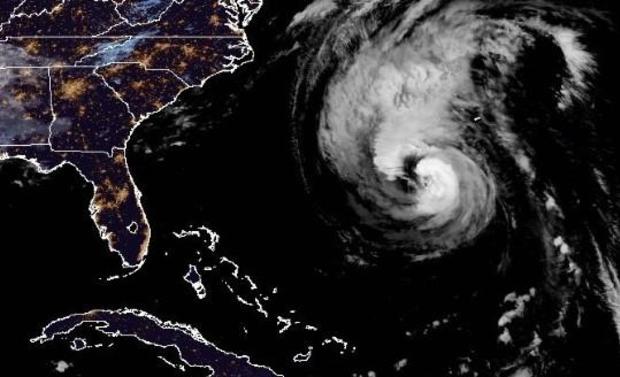
Hurricane Lee, which became the season's first Category 5 storm last week, weakened to a Category 1 on Thursday as it continued churning northward on a path that could reach New England this weekend. The National Hurricane Center has issued its first hurricane and tropical storm watches for portions of the northeast U.S. coast.
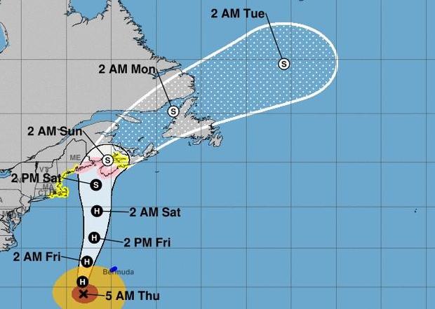
As of 11 a.m. EDT Thursday, Lee had maximum sustained winds of 90 mph. It was centered about 245 miles west-southwest of Bermuda and 750 miles south of Nantucket and was heading north at 14 mph.
"On the forecast track, the center of Lee will pass west of Bermuda today and tonight, approach the coast of New
England and Atlantic Canada Friday and Saturday, and move across Atlantic Canada Saturday night and Sunday," the hurricane center said early Thursday. "Weakening is forecast, but Lee is expected to remain a large and dangerous hurricane for the next couple of days."
Hurricane-force winds were extending outward up to 105 miles from Lee's center and tropical-storm-force winds extended outward up to 290 miles.
A hurricane watch was in effect for Stonington, Maine to the U.S./Canada border and a tropical storm warning was posted for Bermuda. A tropical storm watch covered Watch Hill, Rhode Island to Stonington, Maine, Block Island, Martha's Vineyard and Nantucket. Cape Cod Bay and Nantucket were under a storm surge watch.
"Swells generated by Lee are affecting portions of the Lesser Antilles, the British and U.S. Virgin Islands, Puerto Rico, Hispaniola, the Turks and Caicos Islands, the Bahamas, Bermuda, the east coast of the United States, and are beginning to reach Atlantic Canada," the hurricane center noted early Thurssay. "These swells are likely to cause life-threatening surf and rip current conditions."
CBS News senior weather and climate producer David Parkinson estimated Monday, "if you sum up all the probabilities," the odds are about 2/3 against any U.S. landfall and a 1/3 chance of landfall along the northeast U.S. coast, most likely north of Cape Cod, Massachusetts.
"Realistically, this looks like a Nova Scotia landfall (as it has all along) with a healthy chance (~25%) of a down east Maine landfall on Saturday/early Sunday," he noted on Tuesday. By that point, he said, it would have weakened to a tropical or post-tropical storm.
"We should expect a pretty decent amount of coastal flooding, especially in places that get battered by nor'easters, as waves at the beach will be in the 12-foot range in spots. Lots of erosion can be expected in Cape Cod and Nantucket," he said, with winds gusting in the range of at least 50 or 60 mph, and at least 4 inches of rain drenching eastern New England.
Parkinson laid out a few possible scenarios for Lee. One would involve a cold front coming off the East Coast that could trap Lee and push it north against the coastline, bringing potentially stormy weather to areas along the coast.
However, if no cold front forms, Parkinson explained, Lee would then potentially stay out at sea for a longer period until it reaches Newfoundland and Labrador in Canada.
Chris Warren, meteorologist for The Weather Channel, also said Friday that a jet stream that is currently dipping south could help determine whether Lee goes "well away from land, or much closer."
Warren added that "regardless" of Lee's path, it will still bring "large waves and dangerous rip currents up and down the East Coast."
As meteorologists predicted, Lee gained strength quickly. Early Wednesday, Lee was a tropical storm with sustained winds of 65 mph — but grew within hours into a Category 1 hurricane on the Saffir-Simpson scale when it reached maximum sustained wind speeds of 74 mph. The following day it exploded from Category 2 to Category 4 and then all the way to Category 5, meaning sustained wind speeds of 157 mph or higher.
Meteorologists consider storms that fall within Categories 3, 4, or 5 to be "major" hurricanes, due to their potential to cause "significant loss of life and damage," the National Hurricane Center says, warning that "catastrophic damage will occur" from a Category 4 or 5 making landfall.
Lee's emergence comes just days after Hurricane Idalia left a path of destruction across the Southeast.
That storm made landfall in the Big Bend region of Florida's Gulf Coast, where it razed homes and downed power poles. It then headed northeast, slamming Georgia and flooding South Carolina beachfront communities, sending seawater into the streets of downtown Charleston. In North Carolina, it poured more than 9 inches of rain on Whiteville, flooding downtown buildings.
Idalia claimed several lives in Florida and Georgia. The financial toll from damage and lost economic activity is expected to be in the $12 to $20 billion range, according to Moody's Analytics.