Maps show why Greenland is so important as the Arctic warms
President Trump has said repeatedly that he wants the United States to control Greenland, refusing to take military action off the table and declaring that he will make the semi-autonomous Danish territory part of the U.S. "one way or the other."
Mr. Trump says the U.S. needs to control the vast, largely frozen island that sits mostly inside the Arctic Circle for security reasons, accusing China and Russia of trying to take it over instead.
Greenland's own democratically elected leaders have rejected any U.S. takeover, with the island's government calling it something they "cannot accept under any circumstance."
There are a number of reasons why Greenland is of such intense interest to the Trump administration, including its natural resources — reserves of oil, natural gas and rare earth minerals. But the physical location of the island on the map — and the sea ice melting around its borders — is also of vital importance.
New routes around the globe
Melting Arctic sea ice has created more opportunity to use northern shipping routes — allowing logistics companies to save millions of dollars in fuel by taking much shorter paths between Asia and Western Europe and the United States. Northern routes were long only passable in warmer months.

There are a couple primary routes through the Arctic becoming more viable, the Northern Sea Route (NSR), which follows Russia's roughly 15,000-mile northern border. That path doesn't bring ships too close to Greenland, and Russia and China have agreed to develop the route together, and have been making greater use of it in recent years.
A Russian commercial vessel, aided by an icebreaker, first traversed the NSR in the winter in February 2021, proving it was possible.
The other route, called the Northwest Passage, comes much closer to Greenland's coastal waters and is more likely the path the Trump administration is concerned with.
The other, longstanding way to get goods from ports in Russia or the manufacturing powerhouses of East Asia is to go south. But that course, through Egypt's Suez Canal, is about 3,000 miles longer.
According to the Arctic Institute, compared to the Suez Canal route, the Northern Sea Route can save shippers as much as 50% in costs, considering fuel and other expenses, by reducing the distance from Japan to Europe, for instance, to only about 10 days compared to the roughly 22 it would take to sail around the southern tip of Africa and then through the Suez Canal.
A 2024 analysis by the Middlebury Institute of International Studies also said the northern route would shave about 10 days of a similar journey from Shanghai, China, to Rotterdam in the Netherlands.
As sea temperatures continue warming and winter ice cover shrinks, shipping traffic via the north is likely to increase, so control over that passage — and the long Greenlandic coastline that it skirts — will be of greater importance.
The U.S. National Oceanic and Atmospheric Administration shared graphs in 2022 predicting the new routes that would become available to regular tankers around Greenland over the coming decades.
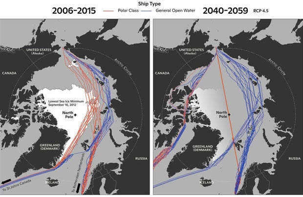
NOAA's modeling shows a dramatic increase in viable journeys for both polar-class vessels fortified to forge through sea ice, and normal open water-faring ships. The agency even predicts that by 2059, it will likely be possible for a polar-class vessel to sail the most direct route, right across the North Pole, as the formation of sea ice reduces further.