February 2024 was the hottest on record, with global temperatures surpassing critical climate threshold
The world has marked yet another consecutive month of record-breaking heat. New data from Copernicus, the European Union's climate change monitoring service, shows that last month was the hottest February on record globally, with "exceptionally high" temperatures in both the air and sea.
The record heat comes as the U.S. continues to battle weather extremes. In recent weeks, communities across the nation have seen spring- and summer-like temperatures, extreme rain and flooding, massive snowfall, and fire weather conditions that drove Texas' largest-ever wildfire that quickly became one of the biggest in U.S. history. Those kinds of extremes are a byproduct of the climate change-fueled rise in global temperatures, and are only expected to become more frequent and intense as warming continues.
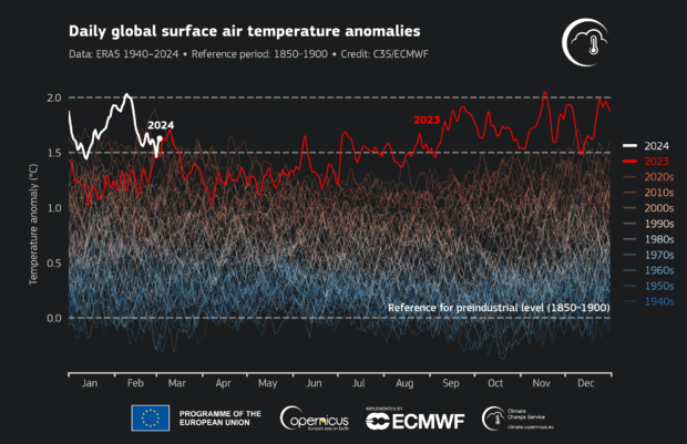
According to Copernicus, the average global surface air temperature in February was 13.54 degrees Celsius (roughly 56.4 degrees Fahrenheit). That is 1.77 degrees Celsius above the pre-industrial average for February, leading it to become the ninth consecutive month where each month was the warmest on record globally. That comes after 2023 broke the record for the warmest year.
The highest February temperatures, deemed "exceptionally high," were seen within the first two weeks of the month, Copernicus found. Scientists with the group said that the daily global average temperature during that time reached 2 degrees Celsius above the pre-industrial average on four consecutive days, from Feb. 8 to 11.
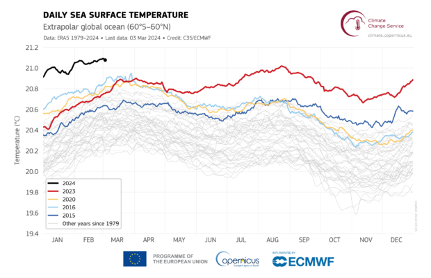
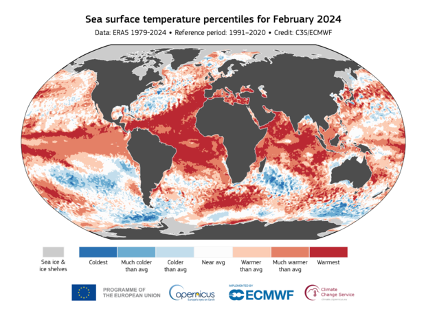
The world's oceans — which absorb 90% of Earth's heat — also saw record high temperatures. Copernicus found that the average global sea surface temperature for February was 21.06 degrees Celsius (69.9 degrees Fahrenheit), which the agency said is "the highest for any month in the dataset."
Such high ocean temperatures only add to the cycle of global warming. Warming oceans lead to melting sea ice, which is vital in reflecting the sun's rays to help maintain cooler temperatures. Without the ice, sea levels continue to rise and temperatures continue to increase, two factors that fuel extreme weather events.
Warmer oceans also lead to rampant coral bleaching, further threatening marine ecosystems and economies.
Climate scientists have long warned of several climate thresholds that put the world at further risk of weather extremes that threaten people worldwide, primarily those who live along coasts and on islands. Those thresholds include reaching several years of global temperatures 1.5 degrees Celsius above pre-industrial levels, or an even more dire 2 degrees of warming. January marked the first time on record that global average temperatures reached the 1.5 degree warming threshold over a 12-month period.
February surpassing those milestones does not mean the world as a whole has surpassed the threshold, but it does indicate that human activities are continuing on a path of doing so.
Carlo Buontempo, director of the Copernicus Climate Change Service, said that while the data is "remarkable," it's "not really surprising as the continuous warming of the climate system inevitably leads to new temperature extremes."
"The climate responds to the actual concentrations of greenhouse gases in the atmosphere," he said. "So unless we manage to stabilize those, we will inevitably face new global temperature records and their consequences."
The recent records come amid an ongoing El Niño event that started last summer. The system occurs every two to seven years when the Pacific Ocean experiences "warmer-than-average" surface temperatures. The most recent El Niño peaked in December, and at that peak, the World Meteorological Organization said it was "one of the five strongest on record."
"It's now gradually weakening, but obviously it will continue to impact the global climate in the coming months," WMO spokesperson Clare Nullis said at a recent briefing. "So even after it disappears completely, we will still feel the impacts of this event."
This El Niño in particular was at least partially fueled by human activity, she said, as humans continue to burn fossil fuels, releasing greenhouse gases that essentially blanket the atmosphere, trapping in heat from the sun.
"El Niño is a naturally occurring event, but everything now, all El Niño events, all La Niña events, take place in the context of a climate which has been radically changed by human activities," Nullis said. "We do expect above-normal temperatures in the coming months."