What are El Niño and La Niña and how do they affect temperatures?
Nearly 100 million people in the U.S. will face triple-digit temperatures by the end of the week as a massive heat wave moves across the southwestern U.S.
Reoccurring weather phenomena are playing a critical role in the scorching heat, and could be a contributor to it getting worse. El Niño and La Niña — opposing extremes that cycle with each other as sea surface temperatures, rainfall, air pressure and atmospheric circulation vary — play a major role in global temperatures.
What is El Niño?
This year marks the return of El Niño, a natural climate phenomenon that develops every two to seven years when the Pacific Ocean experiences "warmer-than-average" surface temperatures. NOAA explains that the event weakens trade winds as warm water is pushed toward the west coast of the Americas, causing the Pacific jet stream to move south.
This transition causes the northern U.S. and Canada to experience dryer and warmer weather than usual, while the Gulf Coast and Southeast U.S. see more precipitation and flooding.
What is La Niña?
La Niña is El Niño's equally impactful opposite, causing trade winds to be "stronger than usual," according to NOAA, and pushing warm water toward Asia. The colder waters in the Pacific Ocean force the aforementioned jet stream more north, generally causing drought in the Southwest U.S., while leading to more precipitation and flooding in the Pacific Northwest and Canada and a more intense Atlantic hurricane season.
Winters during these time periods tend to be warmer in the South of U.S. and colder in the north.
How do El Niño and La Niña impact temperatures?
Both events can greatly impact temperatures across the world, especially when compounded with climate change.
Michelle L'Heureux, a climate scientist at NOAA's Climate Prediction Center, explained in June that El Niño can "lead to new records for temperatures, particularly in areas that already experience above-average temperatures during El Niño."
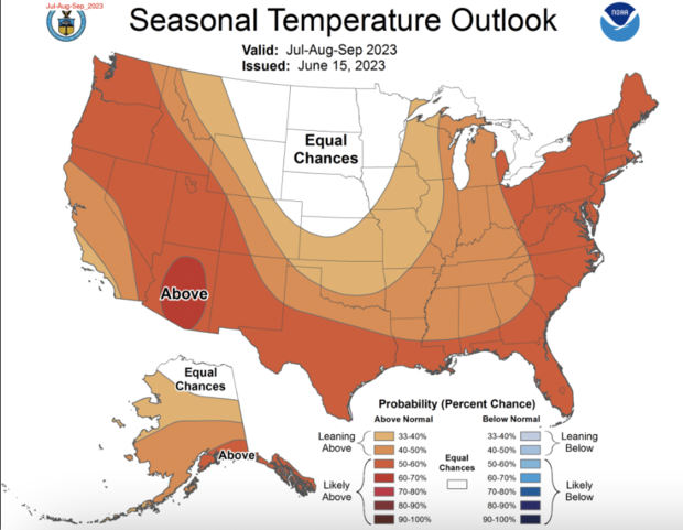
On June 15, NOAA issued a seasonal outlook that says the majority of the U.S. is expected to see "above-normal" average temperatures from July through September, particularly in the West, Gulf Coast and East regions. These temperatures seem to already be slamming these areas, as The Weather Channel described a "July scorcher" hitting the U.S. just the second week into July.
Many states are expected to see triple-digits the week of July 10, Weather Channel meteorologist Stephanie Abrams said on "CBS Mornings."
"By Friday, it will feel like 100 degrees [Fahrenheit] or more for 90 million Americans, actually more than 90 million Americans here, across the South," she said.
Maps show that on Monday, roughly 53 million Americans were already feeling such temperatures, with 98 million expected to feel that kind of heat by Friday.
Phoenix, Arizona, has had its 10th straight day of heat at or above 110 degrees Fahrenheit, Abrams added, a record that could be broken if the spell doesn't break. On Sunday, the National Weather Service warned of "prolonged dangerous heat," saying a "long-duration heatwave" will persist through at least next Sunday.
How will climate change impact El Niño and La Niña?
The future of El Niño and La Niña is expected to be more intense than it is now.
In 2020, the American Geophysical Union published research on the cycle. Michael McPhaden, a senior scientist at NOAA's Pacific Marine Environmental Laboratory and a co-editor of the research, said the events could change as greenhouse gas concentrations in the atmosphere continue to increase. These gases are known for acting as an insulator of sorts for the sun's radiation, causing global temperatures to increase as more of the gases –largely emitted from the burning of fossil fuels– fill the atmosphere.
"Extreme El Niño and La Niña events may increase in frequency from about one every 20 years to one every 10 years by the end of the 21st century under aggressive greenhouse gas emission scenarios," McPhaden said, according to NOAA. "The strongest events may also become even stronger than they are today."
NASA Chief Scientists and Senior Climate Adviser Kate Calvin told "Face the Nation" on Sunday that when La Niña was around last year, it was the "warmest La Niña year we have ever had," tying for the fifth-warmest year overall.
These events, which are determined by ocean heat, will likely change as ocean heat changes. But oceans heat slower than land, meaning that any extra heat brought from El Niño will likely only compound the already excessive heat being felt.
"Oceans absorb a lot of heat, and so we are seeing increases in ocean temperature," Calvin told Margaret Brennan. "But the thing to keep in mind is, oceans are actually –land is warming faster than oceans. So, the places where we live are warming faster than the ocean. So, while we are seeing these increases in ocean temperatures, we're also seeing increases in temperature over land."