South Florida could be threatened by disturbance in NW Caribbean with soaking rainfall: Tracking the Tropics
MIAMI - As we head into the peak of hurricane season, the CBS News Miami NEXT Weather team is focused on the tropics at the beginning of the week with an area of disturbed weather in the northwestern Caribbean Sea this weekend.
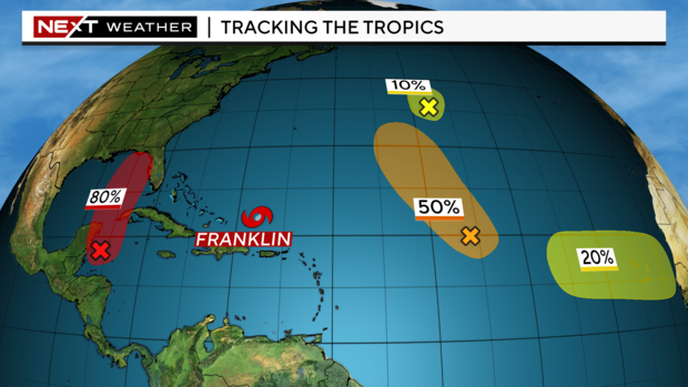
The National Hurricane Center gives the area an 80% chance of development over the next seven days as of Friday evening.
This would be a gradual development as the system lifts northward into the eastern Gulf of Mexico. If it strengthens into a named storm, it would be Idalia.
CBS News Miami NEXT Weather Chief Meteorologist and Hurricane Specialist Ivan Cabrera says an upper-level trough will call the shots on the evolution of any potential system and its level of organization.
He points out that the latest European model depicts an organized system lifting northward in the Gulf of Mexico due to a weaker trough which would create more favorable winds for it. However, the American model continues to depict a stronger trough which would create more southwesterly shear keeping the system weaker and disorganized.
Whether this develops or not, we will see plenty of deep tropical moisture that will bring South Florida heavy rain and the potential for flooding as this system is expected to become a tropical depression or a tropical storm. As of now, the models are in a bit of a disagreement on the exact track and intensity.
South Florida will likely be on the east side, or the dirty side, favoring heavy rainfall and gusty winds. The timeline for the rain impacts is from late Monday to early Wednesday.
As of now, the weekend is not looking bad. We'll see scattered showers with highs in the low 90s. Monday and Tuesday, the rain chance goes up to 70 percent as our weather all depends on what happens with the disturbance in the Gulf.

Meanwhile, Tropical Storm Franklin continues to lift to the north and could become the first Category 2 hurricane of the season.
Friday morning, the storm was about 215 miles east-northeast of Grand Turk Island. It was moving to the east-northeast at 6 mph with sustained winds of 60 mph.
A sharp turn toward the north is expected Friday night and Saturday, with a northward or north-northwestward motion over the western Atlantic continuing through early next week.
Gradual strengthening is forecast, and Franklin will likely become a hurricane over the weekend.


