Idalia downgraded to tropical storm
MIAMI -- With the 5 p.m. advisory, Hurricane Idalia was downgraded to a tropical storm.
Idalia lost some steam after it made landfall in northern Florida, crossed the state, and entered Georgia.
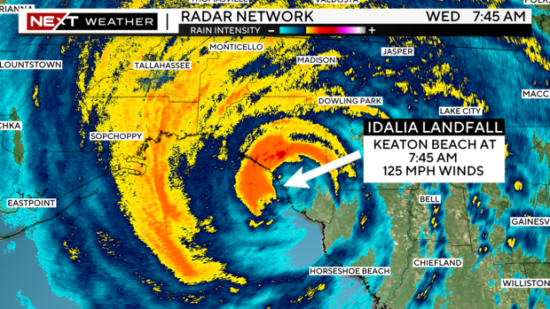
The center of Idalia came ashore early Wednesday morning on Keaton Beach, which is about 75 miles southeast of Tallahassee. It was a Category 3 hurricane with 125 mph winds.
Idalia was briefly a Category 4 hurricane early Wednesday morning but lost some of its strength before landfall.
The 8 a.m. advisory from the National Hurricane Center, noted the storm's winds had dropped to 120 mph. An hour later, Adalia dropped to a Category 2 hurricane with sustained winds of 110 mph.
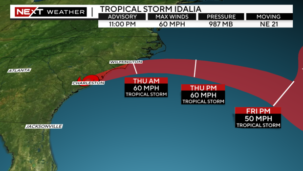
In the 2 p.m. advisory, sustained winds had dropped to 75 mph with the storm being about 100 miles west-southwest of Savannah, Georgia. It was moving northeast at 20 mph.
On the forecast track, the center of Idalia will move across southeastern Georgia today, near the coast of South Carolina tonight, and just offshore the coast of southern North Carolina on Thursday. Idalia is then expected to move east-southeastward over the western Atlantic on Friday.
Locally, South Florida will continue to deal with windy conditions Wednesday along with the occasional gusty rain band. Wind Advisories are in effect through 7 p.m. for Miami-Dade and Broward counties with gusts up to 40 mph possible.
Thursday and Friday, enough moisture will remain in place trailing Idalia to allow for additional rounds of scattered storms, though winds will be much lighter.
By the holiday weekend, we should actually see some drier air wrap in on the back side of Idalia and lower rain chances, along with humidity, leading to a nice Labor Day!
On the forecast track, the center of Idalia will continue moving across southeastern Georgia through Tuesday evening, near the coast of South Carolina Tuesday night, and just offshore the coast of southern North Carolina on Thursday. Idalia is then expected to move east-southeastward over the western Atlantic on Friday.
A storm surge in northern Florida could be up to 5 - 8 feet, in Tampa 2 - 4 feet, and 1 - 3 feet in southwest Florida.
Idalia is expected to produce a swath of 4 to 8 inches of rainfall with isolated maxima up to 12 inches from the northern part of Florida through central Georgia and South Carolina, and through eastern North Carolina into Thursday. These rainfall amounts will lead to areas of flash, urban, and moderate river flooding, with considerable impacts.
In South Florida, we will see gusty rain bands with the potential for 1-2 inches of rain with isolated higher amounts. It will be windy with gusts of 35 to 45 mph. Miami-Dade and Broward will be under a Wind Advisory from 10 a.m. to 7 p.m. On Thursday, the weather begins to improve with the potential for scattered storms.
A few tornadoes are possible this morning across west-central and northern Florida into southeast Georgia.


