Tropical Storm Cristobal: Center Of Tropical Storm Cristobal Makes Landfall Southeast Louisiana
MIAMI (CBSMiami) – The center of Tropical Storm Cristobal made landfall in southeast Louisiana.
At 5 pm. Sunday, the center of the storm was about 50 miles south-southeast of New Orleans.
Cristobal is moving toward the north near 7 mph, and this general motion is expected to continue this afternoon, followed by a gradual turn toward the north-northwest later this evening and tonight.
On the forecast track, the center of Cristobal will approach the northern Gulf of Mexico coast this afternoon, then move inland across southeastern Louisiana this afternoon through Monday morning, and northward across Arkansas and Missouri Monday afternoon into Tuesday.
Data from NOAA Doppler weather radars and offshore oil platforms indicate that maximum sustained winds remain 50 mph with higher gusts. Little change in strength is forecast before landfall.
Gradual weakening will begin once Cristobal moves inland.
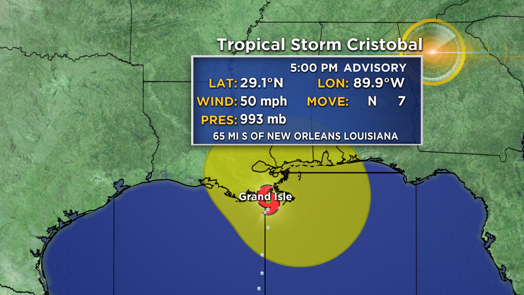
Tropical-storm-force winds extend outward up to 205 miles from the center. During the past couple of hours, an oil rig located about 80 miles south of Mobile, Alabama, measured a sustained wind of 51 mph and a gust to 64 mph at an elevation of 123 ft. A NOAA automated observing station on Dauphin Island, Alabama, recently reported a sustained wind of 42 mph and a gust to 48 mph, and a Weatherflow site on Ship Island, Mississippi, observed a sustained wind of 41 mph and a gust to 51 mph.
SUMMARY OF WATCHES AND WARNINGS IN EFFECT
A Storm Surge Warning is in effect for:
- Mouth of the Mississippi River to Ocean Springs Mississippi
- Lake Borgne
A Storm Surge Watch is in effect for:
- East of Morgan City Louisiana to the mouth of the Mississippi River
A Tropical Storm Warning is in effect for:
- Intracoastal City Louisiana to the Okaloosa/Walton County Florida line
- Lake Pontchartrain and Lake Maurepas
A Storm Surge Warning means there is a danger of life-threatening inundation, from rising water moving inland from the coastline, during the next 36 hours in the indicated locations. This is a life-threatening situation. Persons located within these areas should take all necessary actions to protect life and property from rising water and the potential for other dangerous conditions.
Promptly follow evacuation and other instructions from local officials.
A Storm Surge Watch means there is a possibility of life- threatening inundation, from rising water moving inland from the coastline, in the indicated locations during the next 48 hours.
A Tropical Storm Warning means that tropical storm conditions are expected somewhere within the warning area within the next 24 hours.


