Mudslide concerns remain near California's burn scar areas as heavy rain falls in LA County
An extended period of heavy rain raised concerns over potential mudslides in recent burn scar areas, including Malibu, Altadena, and other regions over the weekend.
Early Sunday afternoon, a number of small mudflows caused road closures in areas near where the Palisades Fire burned in earlier January, also prompting Malibu school officials to cancel school on Monday.
One such debris flow trapped several cars in Woodland Hills, just north over the Santa Monica Mountains from the Palisades Fire burn scar, including a Los Angeles Fire Department fire engine.
Residents were advised to take precautions, such as staying informed about weather forecasts and emergency alerts, creating a family emergency plan with a designated meeting point and evacuation route, having a battery-powered radio, flashlight, and first aid kit on hand, avoiding burn areas and unnecessary travel, and following evacuation orders if issued.
In response, the Los Angeles County Sheriff's Department has issued a mud and rockslide warning advisory for residents of Altadena and Malibu, highlighting these areas as being at "high risk" for both hazards.
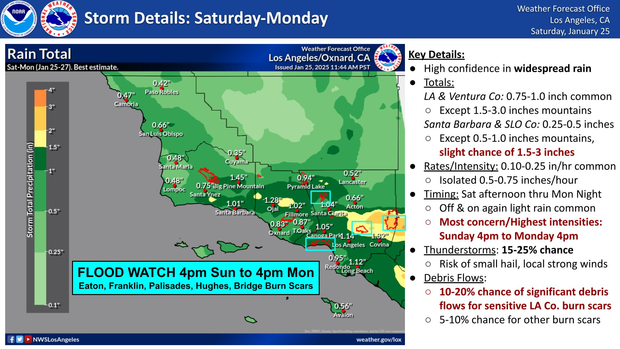
A Flood Watch was in effect for areas impacted by the Palisades, Franklin, Eaton, Bridge, and Hughes fires. It has been extended through 4 p.m. Monday, and later on Sunday the National Weather Service issued a brief flash flood warning in Malibu near the Franklin and Palisades fire burn scars due to the heavy rain.
Rainfall rates stayed under a quarter inch per hour through the early afternoon, but increased rates began in the early evening falling at a quarter and a third of an inch per hour, according to the NWS. Several areas experienced thunder and lightning strikes, including in Santa Monica, Malibu and Studio City.
Heaviest rain is expected Sunday into Monday. The NWS says thunderstorms could bring brief heavy downpours, gusty winds, and a chance of small hail, with waterspouts possible over coastal waters.
Concerns remain high in Malibu, where although rain was been light and steady overnight heading into Sunday, intensifying rainfall in the late evening created increased risks in burn areas, especially those affected by the recent Palisades fire and last month's Franklin fire.
The rain was also affecting areas like Malibu Canyon Road, which remains susceptible to landslides. As a precaution, Los Angeles County Public Works closed the roadway from 5 p.m. on Sunday until 5 p.m. on Monday.
Motorists are encouraged to avoid burn areas and mountain roads during storms, if possible. Residents should remain alert and follow evacuation orders if necessary, as the weather is expected to worsen later today.
In the mountain communities, temperatures are around 30 degrees, and a winter storm warning is in effect. Snow levels will range from 3500 to 4500 feet, with 3 to 8 inches of snow expected across the mountains and 6 to 14 inches in the San Gabriels.
A winter weather advisory has been issued for the Antelope Valley from Sunday evening through early Monday afternoon, where 2 to 4 inches of snow is expected in the foothills, particularly east of Highway 14.
Snow also blanketed parts of the Grapevine, forcing a temporary closure of the I-5 Freeway by California Highway Patrol officers as crews worked to clear the snowfall from the busy roadway.
In Altadena and Pasadena, concerns about the stability of the area persist, particularly in places affected by the Eaton Fire. The rain could loosen debris, leading to dangerous runoff, and there are concerns about pollutants being carried into the area. Efforts are underway to manage water and reduce damage.
Approximately 15,000 K-rails have been set up, and catch basins and drainage systems are being cleared to reduce flooding risks. Workers are wearing gloves while handling potentially contaminated materials in burn scar areas.
The NWS says midweek will bring dry but cool weather, with a weaker storm possible toward the end of the week.


