New Cal Fire hazard maps released for Southern California
The California Department of Forestry and Fire Protection has released updated statewide fire hazard maps for the first time in 14 years, ranking fire likelihood in certain areas from moderate, high to very high.
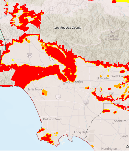
Southern California's mapping came out on Monday, with the following eight counties included: Los Angeles, Orange, Riverside, San Bernardino, San Diego, Imperial, Mono and Inyo. Cal Fire had already released fire maps for Northern and Central California this year.
The new 2025 maps update the previous 2007-2011 models, with zone rankings based on vegetation, terrain, fire history and local weather, according to Cal Fire.
The maps are intended to be proactive, rather than reactive. Cal Fire said they are to be used in wildland-urban interface building standards for new construction, natural hazard real estate disclosures at the time of sale, and point city or county leaders where to apply mitigation measures.
Building standards in the high and very-high fire zones require that newly constructed homes have fire-resistant roofs and rain gutters, outer walls capable of withstanding heat and flames for up to an hour, double-pane windows with tempered, shatter-proof glass and ember-resistant attic and garage vents.
Residents in very high zones also have to meet landscaping requirements. A 100-foot defensible space clearance around homes and adjoining decks must be maintained, trees need to be trimmed, dead or dying vegetation must be removed and flammable brush must be cleared. Property development standards also include road widths, water supply and signage.
On a broader scale, the maps are to be informative for city and county future development plans and help strengthen fire safety policies.
Specific features make some areas more hazardous than others, and Cal Fire is required by law to map areas with significant fire hazards.
The new maps are interactive and show comparison data from old (2007-2011) Fire Hazard Severity Zones with new (2025) zones. Users can also enter specific addresses to see what zone they fall into if any at all. Another new feature of the 2025 maps shows what agency is responsible for each area, state or local firefighters.