Snow is here. Here's what to expect in Chicago.


CHICAGO (CBS) — A Weather Alert is in effect for periods of snow overnight into Friday morning dropping visibility and making roadways slick.
A compact storm is moving through the area, generating periods of snow that will peak between 4 a.m. and 9 a.m. Friday. Areas that see heavy snow during the morning drive will see roadways turn hazardous quickly—although temperatures in Chicago will be near or just above freezing during the worst of it, potentially keeping some roadways wet or slushy.
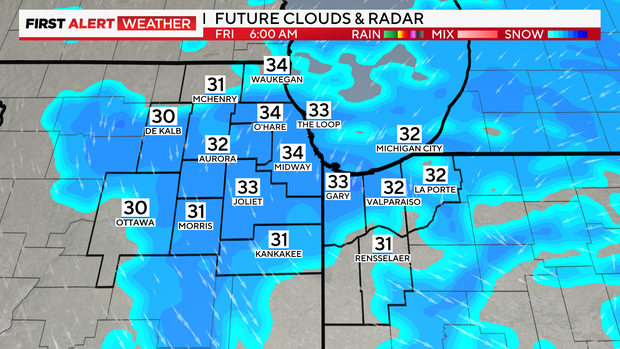
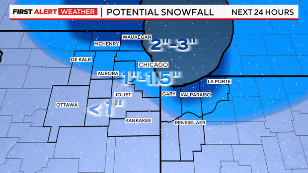
Snowfall accumulations generally will be around 1 to 2" in Chicago once the snow ends late Friday morning. The latest forecasts show areas south of the city will get clipped by the system, dealing out lower snowfall accumulations. However, areas north of the city could get around 3" of snow. Parts of Northwest Indiana also could get around 3" due to lake-effect snow.
Morning snow winds down Friday afternoon with scattered lake effect snow still possible from Chicago into northwest Indiana.
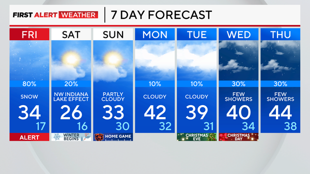
This weekend will bring a break in the weather aside from lake effect snow Saturday in Northwest Indiana. The rest of us will enjoy periods of sun and cold temperatures on the first official weekend of winter.
Highs Saturday will be in the upper 20s. Lows will be in the lower 20s. Breezy northerly winds will also keep lake-effect snowfall around for NW Indiana.
Sunday will be dry across the Chicago area as the lake-effect snow machine turns off. Temperatures in the lower 30s are expected for highs on Sunday.
Next week, will see slightly warmer temperatures for Christmas Eve and Christmas Day with highs in the upper 30s and lower 40s.
Forecast at a glance
Thursday Night: Weather Alert for periods of snow. Low: 31
Friday: Weather Alert early for snow making roads slick. Scattered snow and windy late. High: 34
Friday night: Colder with lake effect snow possible in Indiana. Partly cloudy elsewhere. High: 26