Chicago First Alert Weather: Snow, potential blizzard conditions right before Christmas


CHICAGO (CBS) -- Consider Monday and Tuesday the calm before the storm. The potential for a significant winter weather system is likely to make Christmas travel difficult and, at some points on Friday, nearly impossible.
The National Weather Service has issued a Winter Storm Watch from 9 a.m. Thursday through 6 a.m. Saturday for DeKalb, Grundy, Kane, Kendall, LaSalle, and McHenry counties; from noon Thursday through 6 a.m. Saturday for Cook, DuPage, Kankakee, Lake, and Will counties; and from 3 p.m. Thursday through 6 a.m. Saturday for Lake, Porter, Jasper, and Newton counties in northwest Indiana.
These are expected to be upgraded to Winter Storm Warnings or Blizzard Warnings as the storm approaches.
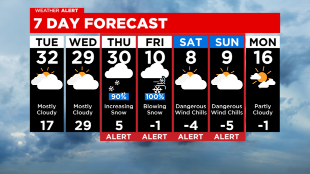
We've got a couple days of prep before a powerful winter storm arrives. Tuesday will bring some afternoon sunshine, with a high around 32. Wednesday will be mostly cloudy, with a high around 29.
Then, it's going to get much colder and snowier though Christmas Day.
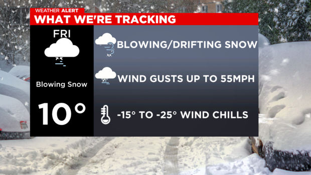
A strong storm is expected to hit Chicagoland with just about everything -- cold temperatures, high winds, dangerous wind chills and potentially significant snow Thursday evening through Friday.
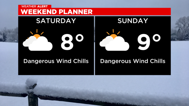
The lows on Christmas Eve and Christmas Day are likely to be in the single digits. Wind chills will likely be well below zero on Christmas Eve and Christmas Day, possibly as low as 25 below zero.
The forecast snow totals range from as little as 6 inches and as much as 18.
Right now it is too early to determine potential snow totals or what areas of Chicagoland will see the worst of the storm. The snow will start falling later on Thursday and continue overnight into Friday. Blizzard conditions are possible and travel could be affected. Power outages due to high winds are also possible, with gusts as strong as 55 mph. The snow clears out by early Saturday but then extreme cold will be the biggest concern.
The National Weather Service said falling and blowing snow could create whiteout conditions at times, with zero visibility, making travel extremely difficult, if not impossible.
CBS 2 meteorologists will have the latest updates as the storm develops.