Chicago Weather Alert: Tracking severe weather
CHICAGO (CBS) -- Dangerous storms swept through the Chicago area in two waves Friday night, bringing flooding, intense winds, hail, and tornadoes.
The storms brought down trees and power lines and left streets flooded. In Belvidere northwest of the Chicago area, the roof of the Apollo Theatre collapsed during the storms -- leaving numerous people injured.
Here is a breakdown of what has happened the severe weather has swept through our area.
Water spouts from drain inside Park Ridge store due to flooding
10 homes destroyed in Whiteland, Indiana
CHICAGO (CBS) -- Central Indiana also got slammed by Friday night's storms.
Whiteland, a suburb about 20 miles south of Indianapolis saw a lot of damage. Police say the southern part of the town took a direct hit from a suspected tornado around 11:30 p.m., knocking down power lines and blocking roads with debris.
The Whiteland fire chief said the winds destroyed at least 10 homes, but no one was killed.
Gov. JB Pritzker issues disaster proclamation following severe storms
CHICAGO (CBS) -- Gov. JB Pritzker Saturday issued a disaster proclamation following severe storms that crossed the Chicago area Friday.
The proclamation will support Boone, Crawford, DuPage, Marion, and Sangamon counties and allow the state to "provide residents the full scale of support needed for recovery," the governor said in a tweet.
"We'll spare nothing to assist those impacted by yesterday's severe weather," he said.
Storms leave dozens of damaged windows at Roberto Clemente High School
According to CPS, Roberto Clemente High School is one of several schools affected by Friday night's severe storms.
The school experienced 45 damaged windows, roof-mounted mechanical equipment serving the kitchen, and uprooted trees in the skate park.
The windows have since been boarded and materials have been ordered with repairs scheduled.
No one was injured in either school.
Chicago Public Schools is on spring break until April 10.
Storms leaves homes damages in Northwest Indiana
ComEd: Power outage updates by county
Lee – 7,551
Winnebago – 6,967
Boon – 1,880
LaSalle – 1,474
Kane – 1,184
Whiteside – 1,142
Cook – 1,133
The ComEd outage map is updated approximately every 15 minutes
Wind advisory, rain and snow showers Saturday morning
The storms have moved on. But a wind advisory remains in effect until 1 p.m. Saturday throughout our area.
Southwest winds Friday night will have speeds of 25 to 35 mph, with gusts up to 50 mph. They will become northwest Saturday morning.
Rain and snow showers will also be around Saturday morning.
Temperatures will be struggling throughout the day.
Tornado warning forces CBS 2 crew to shelter in place
CBS 2's Noel Brennan and his crew had to shelter in place Friday night amid a tornado warning.
Around 8:30 p.m., Brennan and his crew were headed south in the Aurora area when air-raid sirens went off for a tornado warning. Brennan also observed a whole bunch of debris flying across the road, and they had to pull over and get to safety.
Brennan also noted that the storm turned semi-trailer trucks on their sides near the Weber Road exit on I-55, close to Goya Foods headquarters in Bolingbrook.
Heavy-duty tow trucks left the semis back upright.
Traffic in the area was disrupted late Friday night.
Flooded streets in many north suburban neighborhoods
Several rounds of downpours left neighborhoods in Niles and Morton Grove underwater.
For one example, at Lee Street and Oriole Avenue, Niles public works crews worked Friday night to unclog a storm drain that left the street flooded and blocked off for much of the night.
There was also hail so intense that drivers rushed to find refuge. Several cars tried to get under the awning at a Marathon gas station to prevent any damage to their cars.
Meanwhile, the heavy rain pooled up on many residential streets and left them flooded. At Main Street and Ozark Avenue in Niles, cars plowed through the deep water – even though residents said the water was so high that they couldn't leave their homes.
The parking lot of the Niles Portillo's was also left completely underwater.
"It's a swimming pool over here. I mean, we've got the corner lot – so water on one side, water on the other - and thankfully, but we've had issues in the past," said Sofia Stefanis, who lives on a flooded street. "We put a pizza in the oven instead of carryout, because no one's delivering."
Storms rip down large tree in Park Forest
The second round of storms took down a large tree in Park Forest.
The tree came down at Lakewood Boulevard and Westwood Drive in the southern suburb.
Park Forest Public Works was on the scene after the big tree came down. It fell in the street, missing a nearby home.
The second round of storms passed through the south suburbs quickly, but left havoc in its path. There were numerous flash floods – with one woman reporting her backyard was completely submerged in water.
No one was injured when the tree fell.
Parts of area saw hurricane-force winds
Maximum wind gusts in the storms Friday night were 75 mph in Leland, DeKalb County; and Valparaiso, Indiana. Crown Point, Indiana saw maximum wind gusts of 70 mph, Sugar Grove 64 mph, Romeoville 63 mph, and Midway International Airport and Cedar Lake 60 mph.
Keep in mind that winds of 74 mph or greater constitute hurricane-force winds.
28 injured in Belvidere theater collapse
Belvidere Fire Chief Shawn Schadle said five people were rushed from the scene with severe injuries, 18 with moderate injuries, and five more with minor injuries – for a total of 28.
Others likely found their own way to the hospital.
No first responders were injured, Schadle said.
About 260 people were inside the theater for the concert – including the crowd, the staff, and the bands, Schadle said. The capacity of the theater is around 1,500.
Schadle said the MABAS 8 Technical Rescue Team remained at the scene as of the 10 p.m. hour, both conducting secondary searches and working on stabilizing the building.
Illinois lawmaker on Belvidere theater roof collapse
Illinois state Rep. Dave Vella (D-Loves Park) said he was out to dinner with his wife in nearby Rockford, and rushed to Belvidere once he found out about the collapse.
"It's just horrific what's happened. Apollo Theatre is one of the heritage places around here, and this damage is just heartbreaking," Vella said.
Vella said the freak storm caused severe damage in a small area.
"Rockford is only about 10 minutes away, and we didn't get much," Vella said.
Vella said by 10 p.m., everyone had been cleared from the building.
He said hundreds of people were at the concert, and a lot of scared family members were at the scene late Friday.
"This was a huge storm that hit this area, and I tell you, we as a community have been hit hard by a lot of economic stuff right now," Vella said. "This was not a great time for this."
At least one person dead in Belvidere theater collapse
The number of people injured was not immediately learned. We are awaiting a news conference with Belvidere Mayor Clint Morris.
Facebook video shows storm in Belvidere
A Facebook video post by Jayme Carlson shows the storms pounding Belvidere, near a Walmart and southeast of the Apollo Theatre.
It was not immediately clear if a tornado touched down in Belvidere.
Tornado watch ends early for most of area
The tornado watch for Cook County has been dropped. It remains in effect in Northwest Indiana.
Tree falls on house in Aurora
A tree fell onto the roof of a house in Aurora amid the storms.
The oak tree fell om the house at Morningside Avenue and Smith Boulevard, near Phillips Park.
Further details were not immediately available.
Current tornado warnings
A tornado warning remains in effect for central LaPorte and northeastern Starke counties in Indiana until 9:30 p.m.
A separate tornado warning is in effect until 9:30 p.m. for northeastern White and southeastern Pulaski counties in Indiana.
New severe T-storm warning for Northwest Indiana
A new severe thunderstorm warning is in effect for southeast Lake, southern Porter, northern Newton, and all of Jasper counties in Indiana.
It is in effect until 10 p.m.
Roof collapse left Apollo Theatre in Belvidere open to elements
Video from inside the Apollo Theatre in Belvidere showed the ceiling in front of proscenium had collapsed into the auditorium – likely while people were standing in front of the stage.
Outside, the marquee and truss roof collapsed, and bricks were seen in lying in the street.
Information about injuries was not immediately confirmed.
Tornado warning for Lake, Porter counties, Indiana
A tornado warning is now in effect for east central Lake and central Porter counties in Indiana. It is in effect until 9:15 p.m.
Heavy rains flood streets in Niles
Heavy rains left streets flooded in a residential area in Niles amid severe storms Friday evening.
CBS 2's Charlie De Mar reported the flood inundated the intersection of Main Street and Ozark Avenue, near the boundary with Morton Grove.
By 8:20 p.m., the water had subsided as much of it had gone down storm drains.
But earlier, many people reported the water was so high – measured in feet – that they could get out of their homes.
Motorists went on driving through the area, as the dark made conditions more dangerous.
Power outage update
As of 8:48 p.m., ComEd reported 519 active outages, and 44,171 customers without power.
The ComEd outage map is updated approximately every 15 minutes.
Tornado warning in southern Jasper County, Indiana
A tornado warning is now in effect for southern Jasper County, Indiana. It is in effect until 9:30 p.m.
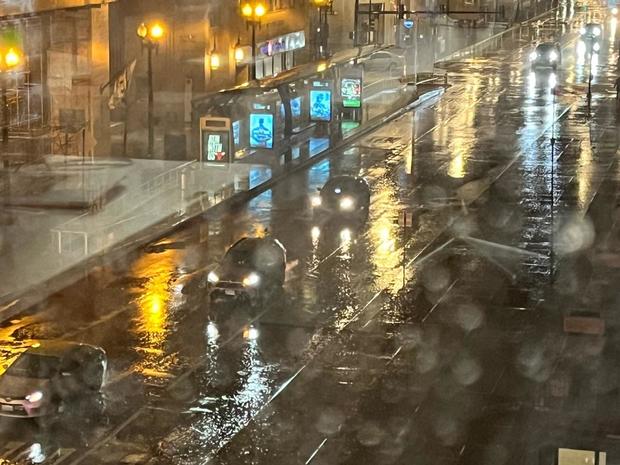
Strong winds hit downtown Chicago
Dangerously strong winds and heavy rain hit downtown Chicago around 8:35 p.m.
The winds died down after a short time, but pouring rain continued.
Tornado warning for southeastern Cook County
There is now a tornado warning for southeastern Cook County due to the aforementioned rotation.
It is in effect until 8:45 p.m.
Bloom Township and Homewood are among the areas in the path of the rotation.
Rotation in storm crossing into southern Cook County
A minor bit of rotation has now begun to ramp up as they move into in southern Cook County.
The area of rotation is crossing from Frankfort into Cook County toward I-57.
No tornado warning had been issued as of 8:33 p.m.
Severe T-storm warning in Lake and Porter County, Indiana
A new severe thunderstorm warning has been issued for northern Lake County, Indiana.
The warning has now been extended to 8:45 p.m., and Porter County has been added.
Tornado warnings now in effect
Tornado warnings are now in effect in Benton County, Indiana southeast of the Chicago area; southeast Iroquois County, Illinois; and Walworth, eastern Rock, and south central Jefferson counties in Wisconsin.
The tornado warnings for the CBS 2 viewing area have expired. But we are not even remotely out of the woods.
Straightline winds are now the main concern with the squall line now bearing down on the Chicago area with wind speeds up to 90 mph.
However, a possibility of tornadoes associated with this system does persist.
Structure collapse at Apollo Theatre in Belvidere amid severe storms
A structure collapse was reported Friday evening during a concert at the Apollo Theatre in Belvidere, Illinois.
The concert began at 7 p.m.
An awning collapse and a partial roof and floor collapse were reported. Numerous ambulances were dispatched to the scene.
Belvidere is located in Boone County, about 72 miles from Chicago.
The Apollo is located at 104 N. State St. at the north end of the Belvidere Business District.
Flooding shuts down Edens Expressway at Winnetka Road
Traffic was halted on the Edens Expressway at Winnetka Road due to a flooded underpass.
In Aurora, there are reports of blown transformers.
Severe thunderstorm warning for most of Chicago area
A severe thunderstorm is now in effect for all of Cook, Lake, DuPage, McHenry, and Will counties until 9 p.m.
This includes the entire city of Chicago.
Severe T-storm warning for Grundy, LaSalle counties
A new severe thunderstorm warning is in effect until 8:30 p.m. for Grundy and eastern LaSalle counties.
A possible tornado is also associated with this system.
New tornado warning south of Chicago area
A new tornado warning is effect until 8:30 p.m. for southeastern Ford and southeastern Iroquois counties.
Severe T-storm warning for Kane, Kendall counties; 90 mph winds
A severe thunderstorm warning is now in effect for Kane and Kendall counties until 8:15 p.m.
A possible tornado and dangerous 90 mph winds are associated with this system.
What to expect with the second round of storms
In this second round of severe weather, a long line of storms is headed eastward toward the greater Chicago area. In its approach, it extended from Madison, Wisconsin south all the way to Peoria.
In Lee County, numerous wires and trees were down in the area of U.S. 30, and semi-trailer trucks were reportedly damaged on U.S. 52 in the Sublette area.
Winds of 69 mph were reported in eastern Lee County.
The squall lines prompting the tornado warnings now affecting DeKalb and McHenry counties will affect the entire Chicago area.
Tornado warning for parts of McHenry County
A tornado warning is now in effect for western McHenry County, as well as Boone, Ogle, and Winnebago counties. It is in effect until 8:30 p.m.
Tornado warning for DeKalb County
A tornado warning is now in effect for DeKalb County, until 8 p.m.
Current tornado warnings
Tornado warnings are now in effect in the following locations, in Illinois unless otherwise indicated:
- Western Lee County, until 7:30 p.m.
- Northeastern Stephenson County, until 7:30 p.m.
- Southeastern Stephenson County, until 7:45 p.m.
- Eastern Green and west central Rock counties, Wisconsin, until 7:45 p.m.
New severe T-storm warning for LaSalle County
A new severe thunderstorm warning is in effect for LaSalle County until 8 p.m. This system is associated with the possibility of tornadoes.
New flash flood warning for Cook, DuPage, Lake counties
A flash flood warning is now in effect for northwestern Cook, northern DuPage, and southeast Lake counties until 11 p.m.
Tornado watch for much of Indiana until 2 a.m.
A tornado watch is now in effect until 2 a.m. Central time Saturday for much of Indiana – including Indianapolis, Marion, Terre Haute, and South Bend.
LaPorte County – which was not included in the tornado watch in effect for the Chicago area until 10 p.m. – is included in this one.
Eastern Indiana municipalities such as Fort Wayne and Angola are not part of this tornado watch.
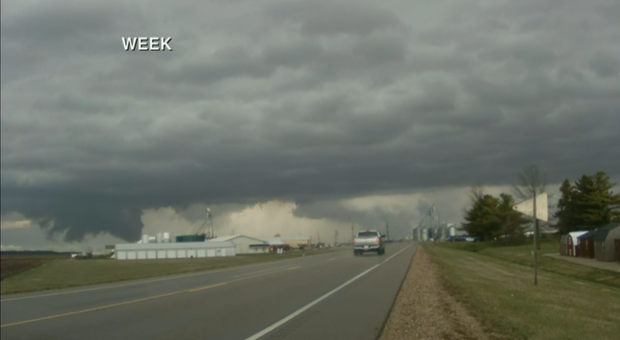
Tornado causes serious damage in Sherman, Illinois
A tornado touchdown was reported Friday evening in Sherman, in central Illinois.
Storm chaser Landon Moeller reported on Twitter that Sherman is in "bad shape." He reported rescuing an elderly woman and her dog.
Moeller's photos showed downed trees, power lines, and a power pole, as well as at least one a structure that had been leveled and damage to several other houses.
Sherman is located north of Springfield.
Tornado warning in Lee County
A new tornado warning has been issued in western Lee County. This is butting up against the CBS 2 viewing area, specifically LaSalle and DeKalb counties.
This tornado warning is in place until 7:30 p.m.
Rain picking up after calm in North Aurora
Surveying conditions from Bolingbrook to West Town
The Mobile Weather Lab made its way Friday afternoon and evening from Bolingbrook to Woodridge – where CBS 2's Sabrina Franza spoke with the mayor.
Mayor Gina Cunningham-Picek said in the past few days, she has been organizing a plan for Monday to help people affected by a tornado that struck there in June 2021.
Franza went through Darien, Westmont, and Elmwood Park – before returning to the city and heading east on Grand Avenue in West Town.
As of 6:45 p.m., there was only drizzle in West Town, but ominous clouds remained overhead. Drivers took it nice and slow, and there were not many people walking around.
Wall of tornado warnings to our west
An enormous amount of land is now under a tornado warning along the Mississippi River where Illinois meets Iowa. Tornado warnings are in effect until 7 p.m. for Carroll, central Whiteside, southern Stephenson, southeastern Henry, western Bureau, and south central Jo Daviess, and southeastern Jackson counties.
This is all associated with the second wave of storms that is headed our way.
Severe T-storm warning now for just DuPage County
A severe thunderstorm warning is now in effect for northern DuPage County until 7 p.m. Cook County is no longer under a warning.
This storm system, which has weakened, is expected to reach downtown Chicago during the 7 p.m. hour.
New tornado warnings far west of Chicago area
A tornado warning associated with the second round of storms is now in effect for south central Whiteside, northeastern Henry, and northwestern Bureau counties until 7 p.m.
This system is headed in the direction of the greater Chicago area.
It appears to be holding together and maintaining its intensity, and the rotation is also expected to persist.
Concern about rotation with storm cell
The storm cell headed in the direction of downtown Chicago was passing over Elburn, Campton Hills, and Blackberry Township as of 6:20 p.m. There is a concern about rotation with this system.
Note that this system is still associated wit the first round of storms. The second round was nearing the Quad Cities as of 6:20 p.m. – with severe thunderstorm warnings, tornado warnings, downpours, and hail.
This is why a tornado warning will be in place until 10 p.m.
Another ground stop at O'Hare
A ground stop is now in place at O'Hare International Airport due to the storms, for the second time.
Incoming flights are halted.
CHECK: Real-time updates
Flash flood warning for Cook, DuPage counties
A flash flood warning is in effect for Cook and DuPage counties until 9:30 p.m.
Several areas have been hit repeatedly with rain.
Flip-flopping conditions in Elmwood Park
Storm cell headed for city
A storm cell is now moving due east toward the city of Chicago. It will pass through O'Hare International Airport at 6:21 p.m., Jefferson Park at 6:31 p.m., Wicker Park in 6:41 p.m., and downtown Chicago at 6:47 p.m.
Severe T-storm warning for DuPage, Kane, Cook counties
A severe thunderstorm warning is now in effect for southern Kane, northwestern Cook, and DuPage counties. It is in effect until 7 p.m.
Wind gusts of 60 mph are possible with this storm system, and a tornado associated with the storm cell is possible.
Pouring rain, hail in Elk Grove Village
Rain was coming down in sheets as of 6 p.m. in Elk Grove Village. The wind had also picked up.
Fifteen minutes earlier, the small pieces of hail were also coming down along with the pouring rain.
The hail was not enough to do damage to any cars, but it was enough to be noisy.
The rain let up after that, only to come down in sheets again 15 minutes later.
Storms destroy barn in Woodford, Illinois
Rain picks up in Oak Park
In Oak Park, conditions had been dry for a few minutes as of 5 p.m., but there had been a bout of thunder – and the rain was back to picking up soon afterward.
An ominous cloud was seen over the Whole Foods store at 7245 Lake St. in adjacent River Forest.
With rush hour approaching, motorists were in for a wet and slightly miserable commute.
Severe T-storm warning in LaPorte County, Indiana
A severe thunderstorm warning is now in effect for LaPorte County, Indiana until 5:45 p.m.
Period of heavy rain in Westmont
Fast, heavy rain in Hammond, Indiana
Severe storms are plowing through Northwest Indiana with intermittent waves of rain.
In Hammond, Indiana, it rained cats and dogs beginning around 4:45 p.m., only for the rain to subside quickly after 10 minutes.
But ominous clouds were seen directly overhead.
Temperatures remained mild as the storm systems passed through.
Tracking tornado warnings
A tornado warning is in effect until 5:15 p.m. for Bureau County west of LaSalle County.
There have yet to be any tornado warnings for the greater Chicago area.
O'Hare ground stop lifted
The ground stop at O'Hare International Airport has been lifted.
Average delays of 51 minutes persist. Delays of 70 mph are reported for arrivals, and 26 minutes for departures.
CHECK: Real-time updates
Dark and ominous cloud in Darien
Heavy rain in Shorewood
Severe T-storm warning in Cook and Will counties in Illinois, Lake and Porter counties in Indiana
A severe thunderstorm warning is now in effect for southeastern Cook and central Will counties in Illinois, and Lake and Porter counties in Indiana.
Severe thunderstorms begin to make their way into southwestern suburbs
Severe T-storm warnings in Will, Kankakee counties
There are two new severe thunderstorm warnings – for eastern and central Kankakee counties until 5 p.m., and for southwestern Will County until 4:45 p.m.
A storm system is moving at 60 mph from Kankakee County into Beecher and Crete, and across the state line to St. John and Gary, over the next half-hour, CBS 2 Meteorologist Mary Kay Kleist reports.
Metra warns to expect delays
Metra is telling riders to expect delays throughout the afternoon and evening due to the storms.
Metra said it will make every attempt to keep trains on schedule.
CHECK: Metra alerts
Ground stop at O'Hare
A ground stop is now in place at O'Hare International Airport due to the storms.
Incoming flights are halted.
O'Hare reported earlier that many airlines are offering waivers so travelers can rebook.
CHECK: Real-time updates
Anyone traveling Friday was advised to check with their carrier for current flight status before going all the way to the airport.
The view on the ground in Plainfield
The view on the ground in Woodridge
Tornado sirens sound, large hail falls near Peoria
New severe T-storm warning for parts of DeKalb, LaSalle counties
A severe thunderstorm warning is now in effect until 5 p.m. for southern DeKalb, northern LaSalle, and southeastern Lee counties.
Quarter-sized hail reported in Streator
Hail of 1 inch in diameter – the same diameter as a quarter – has been reported in Streator.
The Peoria area was hit especially hard with a hail core that caused serious damage. Hail of 1.8 inch in diameter was reported near Peoria.
Adam Gerik posted this image of the hail that hit Peoria on Twitter.
Severe T-storm warning for LaSalle, Grundy counties
A severe thunderstorm warning is now in effect for Grundy and southeastern LaSalle counties. It is in effect until 4:30 p.m.
The view in El Paso, Illinois
This is the view from an Illinois Department of Transportation camera along I-39 in El Paso, Illinois.
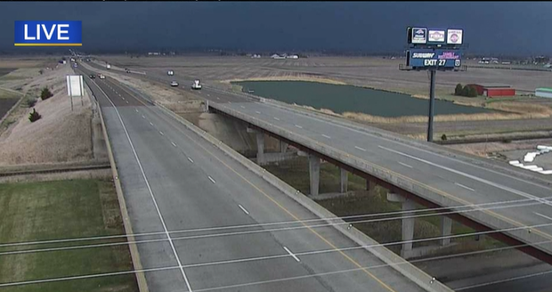
El Paso is a town of about 2,700 that straddles Woodford and McLean counties – about 22 miles north of the Bloomington-Normal area.
The rural town is under a tornado warning, but the National Weather Service reports the tornado risk is beginning to diminish.
Tennis ball-sized hail southwest of Chicago area
Tennis ball-sized hail has been reported in the rural towns of Panola and Minonk southwest of the Chicago area.
Panola and Minonk are both under a tornado warning.
Meanwhile, for a big-picture perspective, this storm system is tapping moisture from the Gulf of Mexico and feeding its way all the way up to the Chicago area.
Dangerous conditions are reported from Texas north to Iowa. Little Rock, Arkansas, and Jefferson City, Missouri, are both experiencing dangerous severe weather.
This image shows a wall cloud in Jefferson City, where a confirmed tornado has been reported.
Severe T-storm warning in LaSalle County; tornado observed southwest of Chicago
A tornado has been observed on conjunction with the storm cell now sweeping over McLean, Tazewell, and Woodford counties.
Meanwhile, considerable damage is expected from 2.5-inch diameter in LaSalle and Livingston counties.
A severe thunderstorm warning is now clipping southern LaSalle County. It is in effect until 4 p.m.
Tracking more storm cells
Another tornado warning is now lifting northeast toward Galesburg City. To the north, an additional severe thunderstorm warning is also in place for a cell over the Mississippi River just east of Muscatine, Iowa.
A situation involving multiple tornado warnings within the Chicago area is possible.
Severe storms are expected to whip through Morris and Joliet, and also southwestern Cook and Kane counties around 5 p.m. By 6 p.m., these storms will push into the South Side of the city.
There is not much of a break expected between the two rounds of storms.
By 8 p.m., all of our western suburbs will fill in with dangerous storms in the second round, which will push closer to the lakefront around 9 p.m.
Severe storm cells moving toward CBS 2 viewing area
As of 3 p.m., a tornado warning was in place in the Peoria area – affecting western Woodford, northeastern Tazewell, and southeastern Peoria counties.
This tornado warning is in effect until 3:15 p.m.
This system also produced golf ball-sized hail that left some vehicles damaged near Peoria.
The storm system that warranted this tornado warning was moving to the north and east at 60 mph, and was on the doorstep of LaSalle County. The storm system could make it to Chicago if it holds together.
A severe thunderstorm warning is also in place for this storm system.
The storm system that produced the tornado warning for the Peoria area will arrive in Granville in 3:25 p.m., Streator at 3:30 p.m., Morris at 3:57 p.m., and Channahon by 4:08 p.m.
Two other storm systems are now located to the west. One cell in the Burlington area in western Illinois has also warranted a tornado warning.
These are also moving at about 60 mph to the north and east.
Storms moving fast
CBS 2's Kris Habermehl has more on the swift-moving weather system headed to Chicago.
Tornado watch for entire Chicago area
A tornado watch has been issued until 10 p.m. for the entire Chicago area – including all counties in the CBS 2 viewing area in both Illinois and Indiana.
Here's the latest timeline of severe weather this afternoon, evening
Severe weather imminent Friday afternoon
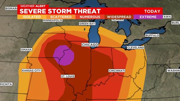
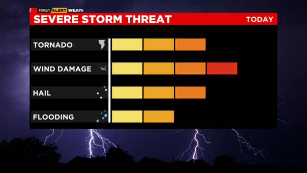
OVERVIEW
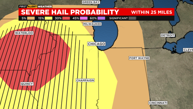
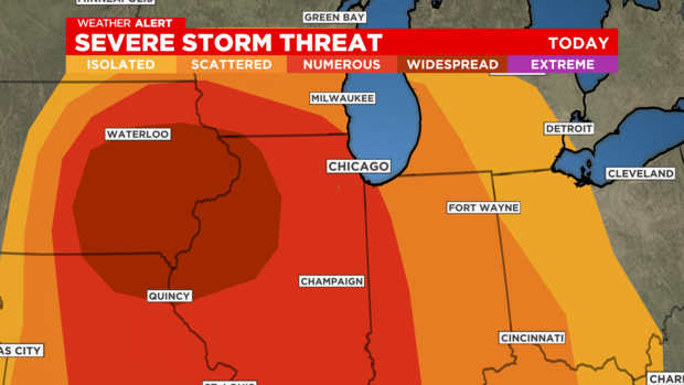
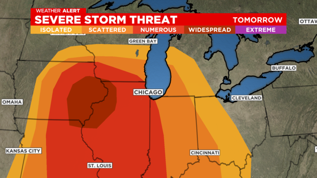
A severe weather outbreak is imminent across Illinois and Iowa today, and will likely spill into our area, including Chicago.
A very rare high risk of severe storms has been forecast by the Storm Prediction Center for western Illinois
Tornadoes, gusty winds (over 70 mph) and hail are all possible!
The threat will arrive in two rounds, and storms will be moving at 60 mph or faster.
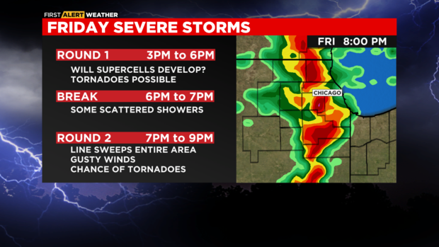
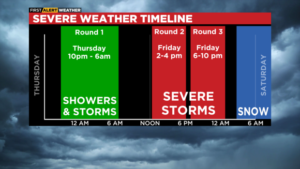
TIMING AND THREATS
ROUND 1
- 3pm to 6pm
- Moves in from SOUTHWEST (La Salle, Kankakee)
- Severe storms develop and move in
- Tornadoes possible, including some strong, long-lived
- Uncertainty remains in the exact "mode" of this line, and its severity
ROUND 2
- 7pm to 10pm
- Moves in from WEST (La Salle, Dekalb, McHenry)
- Intense winds likely with a line of storms
- Tornadoes possible, but not as likely as initial round
WATCHES AND WARNINGS
- We will likely be under a Tornado Watch most of the day
- Likely to be issued by early afternoon
- Tornado Warnings and Severe Thunderstorm Warnings are EXPECTED through the evening
AFTER
- Gusty wins continue even after storms exit, through Saturday
- Gusts likely over 50 mph
- Rain and snow possible Saturday. Little to no accumulation.
High risk of severe storms projected to the southwest
Severe storms with damaging winds arrive Friday afternoon
Waves of storms with threatening conditions are ahead Friday.
Temperatures will be in the mid 60s with the first round of storms moving in this morning. Morning downpours will likely not cause dangerous conditions. Afternoon and evening conditions will impact commuters.
By the afternoon, severe conditions build. Damaging winds and tornadoes are possible as fast moving storms move into the area between 3 p.m. and 9 p.m.
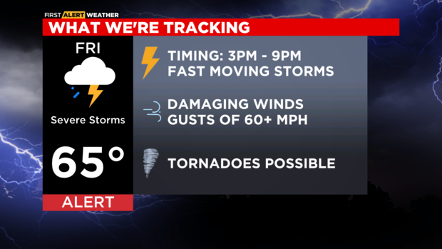
Wind gusts could reach up to 50 miles per hour Friday night into Saturday morning.
A wind advisory will take effect for southern areas near Kankakee.
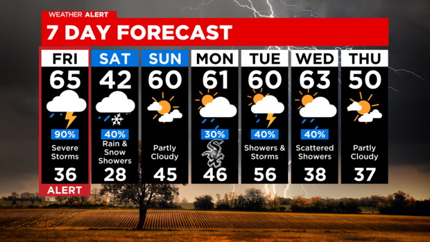
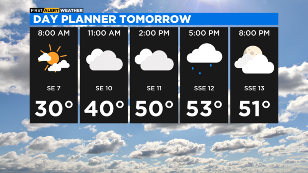
Rain and storms move out by the late evening hours as rain and snow showers return Saturday. High winds will continue to be a threat.
Sunday, temperatures return to the 60s as conditions calm.
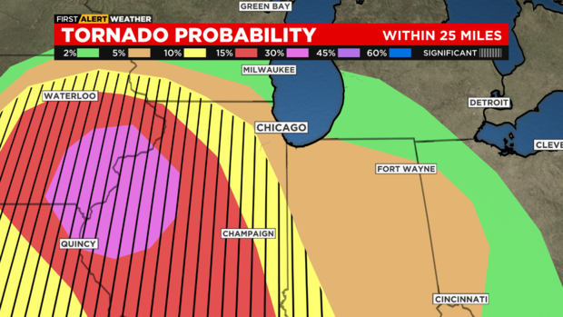
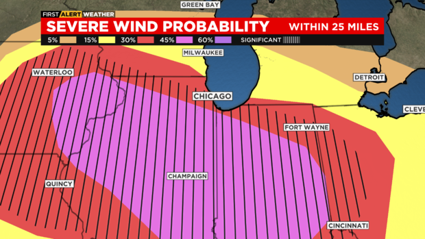
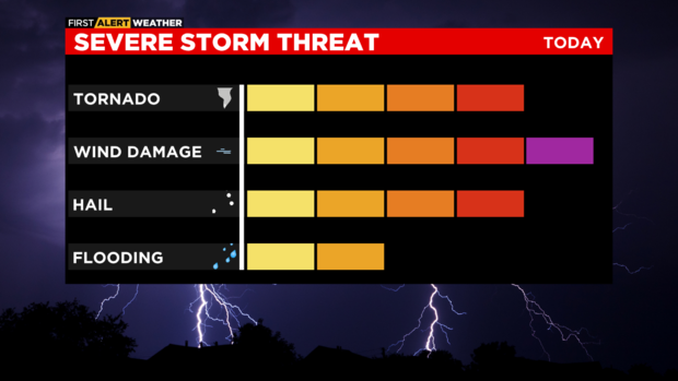
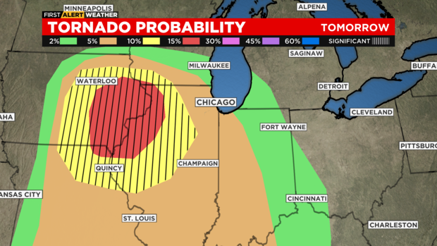
Storm Prediction Center rates Chicago at 3 for severe weather risk
Damaging winds will accompany the strongest storms on Friday. This is our highest weather hazard. Tornadoes are also possible.

The Storm Prediction Center has Chicago at a level 3 on a scale of 1-5. The Quad Cities area is highlighted for the highest tornado threat.
These will be fast-moving storms.
Even though we expect the first round before daybreak, the strongest storms are expected 3-9 p.m.
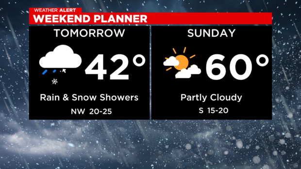
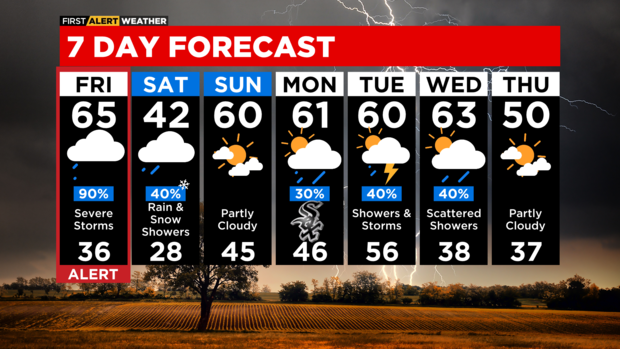
TONIGHT: Showers and thunderstorms early morning. Low 51.
FRIDAY: Severe storm threat. High 65.
SATURDAY: Rain and snow showers. Chilly wind. High 42.
SUNDAY: Partly sunny. High 60.
ComEd prepares crews in case of power outages
ComEd announced it will be opening its emergency operations center Friday morning to ready crews in case of power outages.
"The significant winds that will accompany this storm could be impactful to our customers and communities," Dave Perez, senior vice-president of Distribution Operations at ComEd, said in a news release. "We know that any outage is an inconvenience. Our crews will be working around the clock to restore customers that experience outages quickly and safely."
ComEd noted that it has invested in tree-trimming upgrades to minimize the impact of storms, and said smart grid upgrades have averted more than 19 million power outages since they began in 2011.
When restoring power, ComEd's priority is to restore facilities such as police and fire stations, nursing homes, and hospitals – and then making repairs to restore the greatest number of customers.
ComEd advised the following:
- If a downed power line is spotted, immediately call ComEd at 1-800-EDISON1 (1-800-334-7661). Spanish-speaking customers should call 1-800-95-LUCES (1-800-955-8237).
- Never approach a downed power line. Always assume a power line is extremely dangerous and energized.
- In the event of an outage, do not approach ComEd crews working to restore power to ask about restoration times. Crews may be working on live electrical equipment, and the perimeter of the work zone may be hazardous.
Severe waves of showers, storms over next 24 to 36 hours
Several waves of showers and storms are expected over the next 24 to 36 hours. Storms may include damaging winds, tornadoes and hail.
TIMING
THURSDAY NIGHT
Scattered showers and storms possible are after 10 p.m. While these storms are not expected to be severe, some may be strong and contain gusty winds or hail.
FRIDAY MORNING
That first round of showers and storms will end during the commute. Then a break follows through midday.
FRIDAY AFTERNOON
Storm are expected to arrive after 2 p.m. from the extreme west (I-39 corridor), Expect Severe Thunderstorm Warnings and Tornado Warnings through evening. Gusty winds, tornadoes, and hail are all likely.
FRIDAY EVENING
Storms expected, likely to be severe. Best timeframe for severe/tornado warnings is 5 to 9 p.m., but may be ongoing from earlier and to the west.
FRIDAY NIGHT
Gusty winds will continue AFTER storms exit, possibly to 50 mph.
SATURDAY MORNING
Temperatures will drop and scattered rain/snow showers are expected. Little to no accumulation is expected.