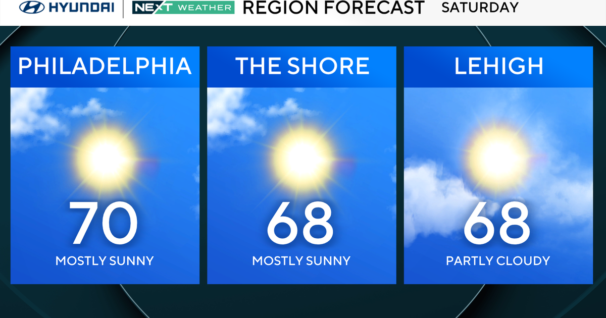
Sierra bracing for first major snowstorm of season; Up to 4 feet could fall above 7,000 feet
SAN FRANCISCO -- A weak cold front was set to roll through Northern California on Saturday, but its just the trailblazer for a more potent system that will bury the Sierra with up to 4 feet of snow by next week.
The National Weather Service has issued a Winter Storm Watch for the Tahoe region beginning Sunday afternoon through late Tuesday night.
"The weak initial system will be blazing a trail for a much stronger low to drop in from the Gulf of Alaska to near the Pacific Northwest coast late Sunday into Monday, then digging into Northern California and eventually pushing inland across California-Nevada for the Tuesday-Wednesday time frame," weather service forecasters in Reno predicted. "This looks to be a classic winter storm setup with near 100% probability of heavy Sierra snowfall."
As for totals, the weather service said the region could be buried under deep snow.
"The mid-range projections indicated in the Winter Storm Watch are quite higher, calling for 1-3 feet down to 5500-6000 foot elevations and 2-4 feet above 7000 feet," the forecasters warned. "High end scenarios show possibility of 3+ feet around parts of the Tahoe basin and 6+ feet near the Sierra crest."
They also issued a warning for motorists planning on trips of I-80 and Highway 50.
"We already saw plenty of travel headaches over the passes earlier this week with a lower-end storm by Sierra standards," the weather service said. "The magnitude of travel impacts will escalate from Sunday night through at least Tuesday, as a relatively short 1-2 hour trip in good weather could take 5+ times longer with life-threatening conditions outside and uncomfortable conditions inside a vehicle going nowhere for long time periods."
The Sunday storm front will also bring welcomed relief to the drought stricken Bay Area.
"If you look at initial estimates of rain from this Saturday and through late night next Wednesday, totals should range from around 0.5-1.5" for valley areas with 1.5-2.5" or more over higher terrain," the weather service said.