Aftermath of storm brings wild Bay Area weather including Sonoma County tornado ahead of next potent system
The heaviest rain from Wednesday's atmospheric river-fueled storm turned into scattered showers Thursday, but wild weather including sudden downpours and even a tornado in the North Bay persisted as another major storm system loomed on the horizon.
The National Weather Service said bands of moderate to occasional heavy rain would lash the Bay Area Thursday with rain rates decreasing as the day wears on. Flood advisories for portions of the Bay Area issued late Wednesday and early Thursday were canceled just before 6 a.m., but a Flood Watch was still in effect for the region through 4 a.m. Friday.
The outgoing storm system combined with colder temperatures Thursday to help create some instability in the Bay Area and Central Coast. The scattered and occasional heavy showers could also be accompanied by some thunderstorms and possible hail, the weather service said.
KPIX First Alert Weather: Current conditions, alerts, maps for your area
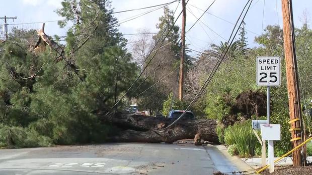
Rare tornado, flooding, toppled trees
The severely unsettled weather even led to a rare tornado in Sonoma County, according to a report by the Press Democrat. The Santa Rosa based newspaper posted an Instagram reel of video it obtained of a brief funnel cloud that touched in a remote rural area of Sonoma County late Thursday morning at around 11 a.m. According to the Instagram post, it was the first tornado to touch down in Sonoma County in over a decade.
KPIX chief meteorologist Paul Heggen confirmed that radar showed a weak rotation signature at the same time the video was recorded.
The weather service said flooding has been mainly of the nuisance variety with flooding of streams, urban areas, and roadways being the primary reports received so far. The gusty winds that downed some trees and knocked out power to scattered areas around the bay, including some in the 60-70 mph range along the highest peaks, were on the downswing Wednesday.
In Los Altos, a large tree fell Thursday morning across Camellia Way on top of power lines and destroyed a fire hydrant, police said. The tree caused a power pole to fall across Springer Road and was affecting the 1300 block of Marilyn Drive just across the Mountain View city limit. Both power and water were out in the area as of 11 a.m., and surrounding roadways were shut down as crews dealt with the downed tree and power poles. No injuries were reported.
In Daly City, a tree toppled onto an apartment building late Wednesday evening but only caused exterior damage. The tree was left in place overnight and crews were removing it and making repairs Thursday morning. No one was injured.
In Santa Cruz County Thursday, flooding closed Paulsen Road north of Watsonville and approximately a mile south of Green Valley Road.
In Mendocino County, the Russian River exceeded flood stage in Hopland early Thursday morning. As of 5:30 a.m., the measurement was approximately 17 inches with flood stage being 15 inches at the Highway 175 bridge. However, a flood warning for the area which had been extended to 9 p.m. Thursday was canceled just before 10 a.m.
Somewhat calm before next storm
Overall rain amounts between Thursday and Saturday were expected to remain light until another strong system that will arrive Sunday.
"More heavy rain and gusty winds are expected, but the timing is still questionable, best estimate right now is midday Sunday through midday Monday," said KPIX meteorologist Paul Heggen. "Wind will be a greater threat compared to [Tuesday] as the heart of the storm tracks right along the coast."
Some 1 to 2 inches of rain is expected across the board, with 2 to 4 inches in the higher elevations of the North Bay and the Santa Cruz Mountains. While some forecast models were predicting double those amounts, Heggen said it was not likely.
The wind gusts are again expected to be forceful, with widespread 40 to 50+ mph gusts capable of significant tree damage given the saturated soils around the region.
Sierra snow dump
In the Sierra, a Winter Storm Warning was in effect through Friday around the Tahoe basin, and through Friday night for the western slope. Snow levels will steadily drop to around 3,500 by Friday; 6 to 12 inches of snow were expected at lake level and up to 3 feet above 7,000 feet.
For the next storm, snow levels will hover around 4,000 and the total snow accumulation between the two systems will be 18 to 30 inches at lake level and up to 5 or 6 feet in the higher elevations.


