Bay Area pounded by heavy rains and high winds, causing flooding and downed trees
The Bay Area was soaked by a powerful storm system overnight into Saturday morning, causing flooding and even triggering what is reported to be the first-ever tornado warning in San Francisco, officials said.
While the strongest part of the system with the heaviest rain and strongest winds has passed, isolated severe thunderstorms were possible for parts of the Bay Area through the morning, the National Weather Service said.
The risk of a severe storm was marginal, and the NWS said it would only last through Saturday morning. According to PG&E, the storm conditions caused power outages for thousands of people in the Bay Area.
An outage map showed about 30,000 customers around the Bay Area were in the dark as of Saturday evening, though some people had their power restored throughout the night.
After that, isolated shower activity is expected throughout the afternoon, but it will be a lot drier today.
A flood advisory was in effect for part of Petaluma until 1:30 p.m., and there was an ongoing Wind Advisory in the Interior Bay Area and Interior Central Coast effective until Saturday, 10 a.m. Coastal flooding is expected along the San Francisco Bay and San Pablo Bay until Monday, 1 p.m.
For Saturday's temperatures, daytime highs will be mostly in the high 50s to low 60s on the coast, mid 50s to low 60s around the bay, and in the mid to high 60s inland. Overnight lows will be mostly in the mid 30s to low 40s.
Drier weather is expected into Sunday, and there is a chance of fog early Sunday morning.
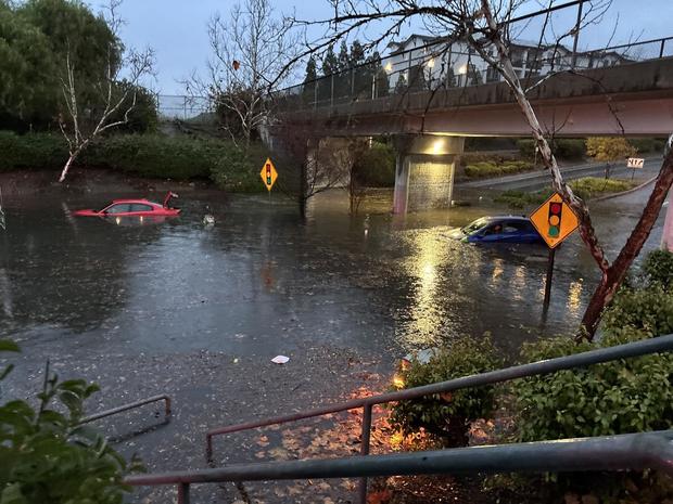
The National Weather Service had forecasted "impactful" rain for Friday evening into Saturday with flooding concerns for the Bay Area. In Livermore, those flooding concerns turned into warnings from police. Livermore police said many of their under-crossings were closed due to substantial flooding and that cars that tried to drive through were getting stuck.
The storm even prompted a tornado warning early Saturday morning.
The tornado warning was issued just before 6 a.m. for San Mateo County and downtown San Francisco. It expired at 6:20 a.m. The Bay Area office of the National Weather Service said the warning was "radar indicated" and there was no confirmation of a tornado touching down.
The tornado warning in San Francisco was just the first of multiple extreme wind events connected to the powerful storm that passed through Northern California overnight and continued to cause problems Saturday.
High winds were causing impacts across the region, including a city-wide power outage in the North Bay city of Novato and a full closure of Interstate 580 in both directions at the San Joaquin and Alameda county line after a multiple-vehicle collision involving a big rig due to high winds.
On Saturday afternoon, a tornado touched down in the Santa Cruz County town of Scotts Valley. Police had initially issued an alert regarding a multi-vehicle accident, but later reported that witnesses said a tornado had touched down on Mount Hermon Drive, throwing "multiple cars off the road."
The Bay Area office of the National Weather Service later confirmed that a tornado had occurred based on "video, photos, firsthand accounts, and radar signatures"


