Atmospheric river set to wreak weekend weather havoc
SAN FRANCISCO -- Forecasters warned on Friday that even a weak atmospheric river has enough of a punch to dump more than 2 inches of rain in the Bay Area and bury the Sierra under several feet of snow over the weekend.
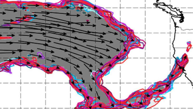
Researchers at Scripps Center for Western Weather and Water Extremes predicted the incoming storm front -- expected to arrive Friday night -- will be a 1 or 2 on their atmospheric river scale depending where you are on the coastline.
Most of California will be at the Stage 1 level and Oregon will be plummeted by a Stage 2.
"High moisture associated with an Atmospheric River will promote heavy mountain snow as well as heavy rain with showers and thunderstorms for lower elevations along the coast," the National Weather Service predicted. "The highest snow totals are currently expected for the Sierra Nevada in California where several feet of snow is forecast."
In the San Francisco Bay Area, a wind advisory was in effect as the front approached with gusts as high as 50 mph.
"These winds are associated with a strong frontal boundary that will produce heavy rain on Saturday," the weather service said. "Strongest winds are expected along the immediate Sonoma Coastline and above 1500 feet."
The rain will arrived late Friday and by daylight Saturday could force the weather service to issue flood advisories for some areas.
"Hard to completely nail down the timing this far out, but looks to be around mid-morning in the Santa Rosa area, late morning for San Francisco and mid-afternoon around Monterey Bay," forecasters also noted of the storm's arrival. "Will also note near-ideal set-up for high rain rates and large rainfall totals over the Santa Lucia Mountains of Monterey County especially and also the Santa Cruz Mountains."
ALSO READ: Latest winter storm to dump up to 4 feet of snow on Sierra
Most of the Bay Area can expect as much as 2 inches of rain before the front clears out on Sunday.
While it will be wet in San Francisco, the storm's major impact will be in the Sierra. A winter storm warning goes into effect at 4 a.m. Saturday and extends all the way to 4 a.m. Monday.
More than 4 feet of new snow was forecasted for Donner Summit and Kirkwood with just about 3 feet expected at Truckee.
"Snowfall rates of 1 to 3 inches per hour for several hours through Saturday and into Sunday, leading to significant snowfall totals of 2 to 5 feet," the weather service said.
But the snowfall will not be light and fluffy.
"This portion of the storm will be heavy, wet Sierra cement type snow due to the subtropical moisture with snow ratios 8 to 1," the weather service said.


