Storm door opens ahead of arriving atmospheric river; Bay Area flood watch in effect Friday
SAN FRANCISCO -- Scattered showers were already falling over the Bay Area early Friday morning as the Bay Area braced for another round of heavy rain that will trigger a flood watch later in the day.
According to the Bay Area office of the National Weather Service, on and off showers are expected throughout the day Bay Area wide on Friday, with the North Bay experiencing higher rain totals with up to an inch falling in the region by midnight.
Friday night will also be breezy with a slight chance of thunderstorms. Low temperatures will be in the mid 50s. Southwest winds will be 15 to 20 mph before switching to south winds of 20 to 30 mph after midnight.
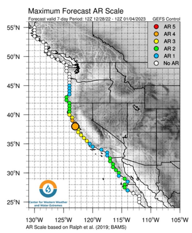
The potent Cat. 4 atmospheric river is set to arrive in the Bay Area Friday evening and has triggered a flood watch for already swollen streams and saturated hillsides.
KPIX meteorologist Darren Peck reports that the flood advisory will go into effect at 4 p.m. for the North Bay Friday afternoon and 10 p.m. for the rest of the Bay Area. Both flood watches will expire at 10 p.m. Saturday.
"A series of systems will bring more rain to Northern and Central California now through New Years Eve day," forecasters warned. "While the rain will be light to moderate at times through Friday, this rain will continue to saturate the soils, and prime the pump for potential flooding."
ALSO READ: Unsheltered residents urged to seek out warming centers during storm
A bigger event is expected Friday night.
"An initial wave of moisture will make its way inland over the Pacific Northwest and parts of California Friday with a potent atmospheric river following on its heel for the end of the week," the weather service said. "Moderate to heavy precipitation is expected along with heavy mountain snow. Most of the potential impacts are anticipated across central/northern California and parts of southwest Oregon where rainfall amounts of 3 to 6 inches are forecast through early this weekend."
"These amounts may lead to scattered instances of flash flooding, especially near recent burn scars where terrain is most susceptible to rapid runoff."
Researchers at Scripps Center for Western Weather and Water Extremes predicted the approaching atmospheric river will more intense than the one that made landfall on Tuesday. The good news is that current models indicate the heaviest rain will fall between Friday night and late Saturday morning, meaning that the storm shouldn't impact New Year's Eve festivities Saturday night.
The first storm dumped nearly five inches of rain on Mt. Tamalpais and also in the Santa Cruz Mountains.
"As this Pineapple Express launches its moisture toward the Bay Area, rain rates will go up," forecasters said. "That said, the plume of highest moisture will be narrow and intense. Models have varied by numerous miles as to where the head of this stream will initially take aim. Some have it in Mendocino County, while others impact San Mateo County."
Unlike Tuesday's storm, this river will not be accompanied by high winds. Still, forecasters warned, there will be gusts that can topple trees weakened by the saturated soil.
"Winds will strengthen ahead of and during the cold front passage Saturday morning into afternoon with gusts of 35 to 50 mph with locally higher gusts over mountain peaks," forecasters warned. "This means increased potential for downed trees/branches and power outages."
While there will be a break in the rain on New Year's Day, there is more stormy weather to come next week.
"(There will be) a brief break on Jan 1 before we move on to our next wet period between Jan 2-5 with the heaviest rain occurring on Jan 4," forecasters said. "Guess what...current WPC guidance is showing that this early January event could bring yet another 1-6 inches of rain to our region."
Residents in the North Bay were bracing for the worst.
Tamalpais Valley resident Becky King tells KPIX that she is worried if the drains near her home can handle the heavy rainfall.
"My house is near a creek that rises above my house level. And they try to enforce it every year, but we usually get flooding," said King. "So, this year I'm a little more concerned."
Creek levels around the county, like the one near King's home, are what the Marin County Fire Department will keep a close eye on during this storm.
"Friday and Saturday seem like the bulk of extreme weather will be, so we'll look at staffing our stations with more people," said Marin County Fire Deputy Chief Chris Martinelli. "If we see creek levels getting up higher that's what will trigger us to staff our water rescue resources."
Meanwhile, residents like Carianne Larsen are doing what they can to weather-proof their homes.
"We cut some tree branches. That's pretty much what we have done, and [got] some sandbags to make sure the garage doesn't get flooded," Larsen said.
The fire department says it's not just high creek levels that could lead to flooding.
"Because of the lack of rain over the past few years, there have been a lot of drains that are clogged with leaf litter that would have been flushed out with storms if we had them," Martinelli said.
Lezla Gooden contributed to this story.


