Windy Wednesday for Northern California before more changes in forecast this weekend

It's been a quiet week across Northern California, with warming temperatures and sunny skies. Wednesday will bring more of the same, yet we'll add another layer of wind to the day.
The wind picks up through the morning before reaching a peak by the afternoon. Wind gusts of 35 to 45 mph will be possible along and west of Interstate 5.
Wind may blow things around in your yard, so make sure to secure items down through the end of Wednesday. The strong wind will have a big impact on those who struggle with allergies.
The Pattern Change
Our weather pattern has been dominated by an area of high pressure across the Pacific. This has been keeping weather systems up to the north across the Pacific Northwest and leaving us dry in return.
A low-pressure system has started to drop into the Great Basin and plains Wednesday, which creates a tighter pressure gradient with the high pressure to our southwest.
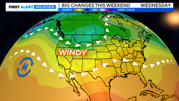
Bringing us stronger north winds across the region. Luckily, fire danger will remain low thanks to the cool and wet weather we've had recently.
This pattern will help keep us warm through the end of the week with highs in the valley reaching for the upper 70s to mid 80s. Expect breezy north-to-east winds Thursday and Friday, yet it will be milder than Wednesday.
High pressure will stay overhead through the end of the week until a colder weather system arrives by the weekend.
Weekend Storm
It is looking more likely that we'll see a big change to cooler and unsettled weather this weekend.
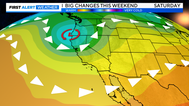
A strong trough of low pressure digs south into Northern California from the Gulf of Alaska bringing another round of widespread rain and even some Sierra snow on Saturday.
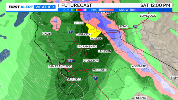
We may see precipitation start as early as Friday night, yet many will stay dry. Weather forecast models have been in good agreement with our best chance of showers on Saturday.
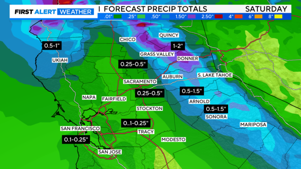
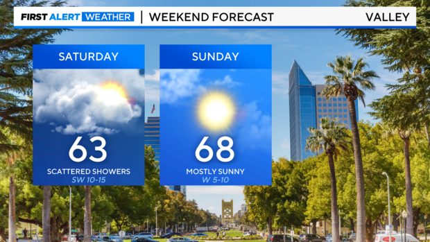
Early precipitation amounts keep the best rain and snow chances across the Sierra and western slopes. As for the valley, we could see 0.25 - 0.50'' of rain by Sunday. Make sure to stay with us as forecast confidence with amounts and timing will increase as we get closer to Saturday.
We'll continue to nail down the timing, yet many models show rain starting early and staying steady through the beginning of the day. But it all depends on the track of this storm. Expect highs to be much cooler this weekend, with 60s on the way for the valley.
Across the Sierra, snow levels will start high at first with levels around 7,500 - 8,000 feet. At first, we may see a mixture of rain and snow before steadier snow arrives by Saturday evening. Depending on the timing of colder air, snow levels could reach 5,500 feet at the lowest point.
Travel will be slick across the Sierra on Saturday and a few delays are possible across mountain passes. Make sure to keep an eye on the forecast before traveling.
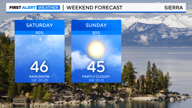
The good news is this storm will be progressive, moving out fast and clearing by Sunday. We may see a few lingering showers on Sunday morning across the mountains and foothills. But if you need to do any yard work outside this weekend, Sunday will be the best day to do it.
Looking Ahead
Past this weekend, it looks like we'll head into another dry stretch of weather by the week of the 6th. Temperatures may be slow to warm at the beginning of next week with highs in the low 70s. By next Wednesday the 8th, highs reach the upper 70s - low 80s again.
Make sure to stay with the CBS Sacramento First Alert Weather team as we keep you updated on this weekend's storm and what you can expect in your neighborhood.


