What to know about the next atmospheric river aimed at the Sacramento region Sunday

The Sacramento region is in for a soaking Sunday as the next atmospheric river moves in, bringing with it heavy rain, snow, and powerful winds.
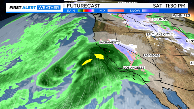
Rain moves in Saturday night
Most of Saturday will be mainly dry in the Sacramento region, but we can't rule out a few scattered showers. Highs will be in the mid-upper 50s.
RELATED: Share your weather photos and videos with CBS Sacramento
Rain will move into the Sacramento area as early as Saturday night, just after sunset, with the bulk of the rain arriving early Sunday and through the afternoon. Snow will begin to pick up across the Sierra as this storm moves in from the south.
Sunday's storm impacts
The next atmospheric river will arrive on Sunday. That's when we're calling for a First Alert Action Day Tier 3. Monday has been added as First Alert Action Day Tier 2, with the biggest impacts in the Sierra.
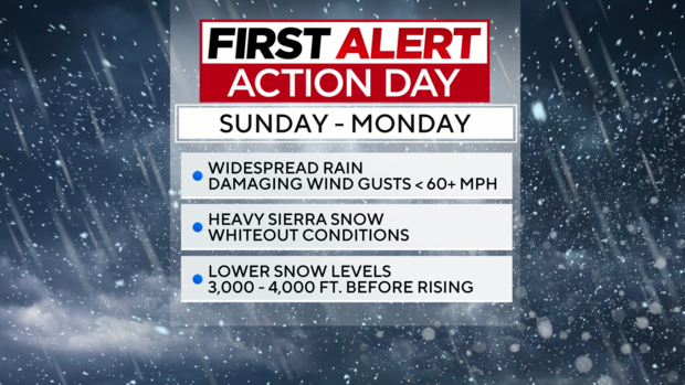
Expect strong winds with gusts up to 60-70 mph in the Sacramento Valley, San Joaquin Valley and foothills. Gusts across mountain passes and peaks in the Sierra could reach gusts up to 70+ mph.
A High Wind Warning has been issued starting at 2 a.m. Sunday through 4 a.m. Downed trees and widespread power outages will be possible.
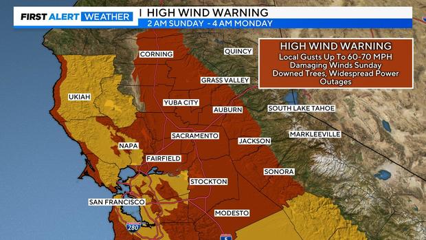
Peak winds arrive through the valley during Sunday afternoon-evening, bringing damaging wind gusts up to 60-70 mp expected. Make sure to take precautions around your home.
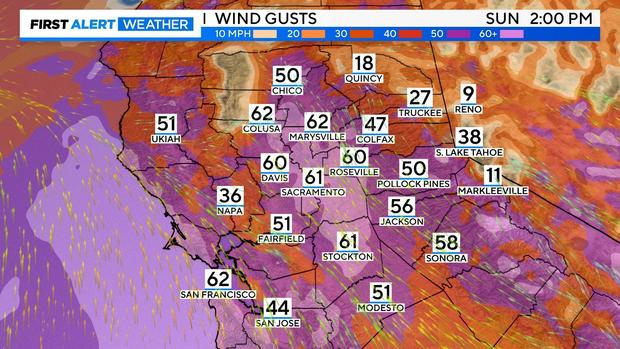
Wind will be high for coastal communities along and south of the Bay Area. The Santa Cruz mountains could see gusts up to 80 mph.
Sunday will be a washout type of day with rounds of heavy rain, creating a bad day to be outside and a bad day for driving.
Heavy rain fills in overnight Saturday with rounds of downpours across the region. We also can't rule out a few isolated thunderstorms, producing gusty winds, brief heavy rain, lightning, and small hail.
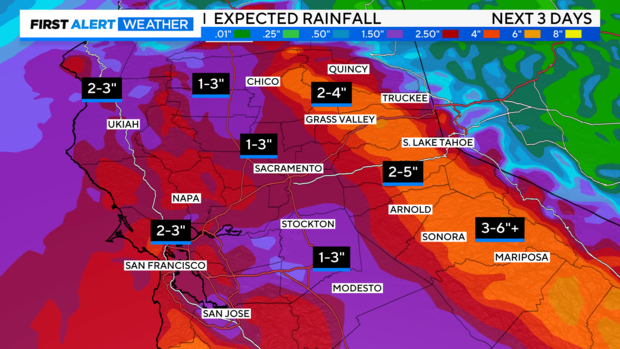
Expected rain totals are 1-3 inches in the Valley and 2-5 inches in the Foothills and the Sierra.
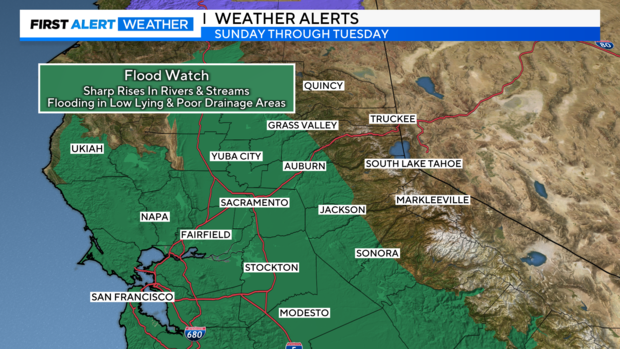
A Flood Watch is in effect from Sunday to Monday. Excessive rainfall will result in flooding of rivers, creeks, streams and flood-prone areas. Creeks and streams may rise out of their banks. Flooding may occur in poor drainage areas and urban areas on local roads where drains become clogged.
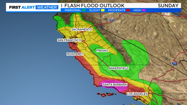
Most of Northern California has been placed at a slight risk, level two, for flash flooding. Our ground is still very saturated from the last several storms, excessive rainfall could lead to flash floods and mudslides across the state. The threat does trend higher the closer you get to Southern California.
The rain begins to start lightening up across the region on Monday, although snow will still be heavy across the Sierra.
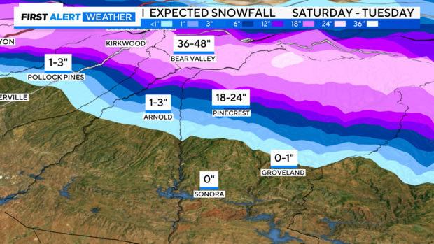
Heavy snow expected in the Sierra
Travel is strongly discouraged across the Sierra on Sunday and early Monday, with major travel impacts expected. CHP Truckee is encouraging people to be prepared if they decide to travel over Donner Summit.
The Sierra will experience whiteout conditions on Sunday, especially Sunday during the afternoon hours. This will be the most significant snowmaker of the season, possibly resulting in the year's first hard closure over the mountain passes.
A Winter Storm Warning will be in effect starting on Sunday continuing through Tuesday morning.
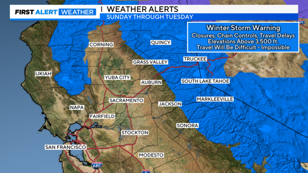
Snow levels will start low, around 3,000 - 4,000 feet before rising through the day Sunday. We're expecting two to four feet of snow by Tuesday for elevations above 6,000 feet.
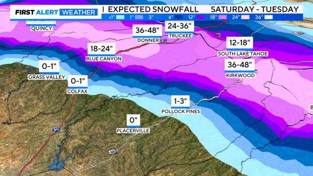
Some of the hardest hit spots will be towards our mountain passes and ski resorts. Expect heavy, wet snow to accumulate fast as it falls.
Severe weather in Bay Area & L.A.
The brunt of the storm's impacts will be outside of the Sacramento region.
In the Bay Area, heavy rain will pose a risk for mudslides and debris flows, especially in the Coastal Range and Santa Cruz mountains. Additionally, large breaking waves are expected to pound the coast.
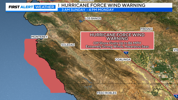
The first of its kind for the region, a Hurricane Force Wind Warning from 3 a.m. to 4 p.m. for the Big Sur coastline south of Monterey is now set for Sunday. This entails southeast winds at speeds of 46 to 57 mph, with gusts up to 86 mph.
In the Los Angeles region, it looks more and more likely that a life-threatening flood event could occur. Santa Barbara County has been included in the high-risk category for flash flooding. Preparations and evacuations in this area should be made before Sunday.
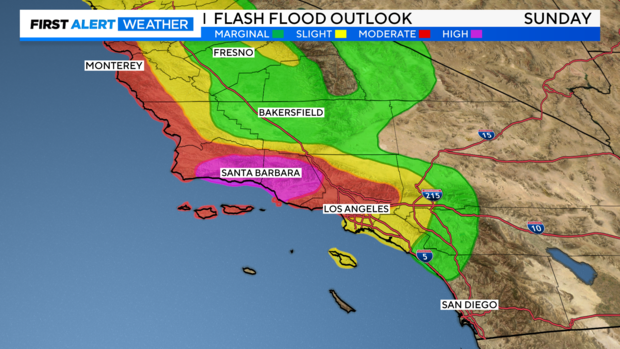
This is especially the case in areas along and south of Point Conception, including Santa Barbara, L.A., and Transverse ranges. These locations may receive 4-8 inches of rain with locally higher amounts -- between 10-15 inches -- along the south-facing mountains.
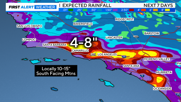
Many from San Diego to the Santa Barbara area, especially those living along the coast need to begin flood preparations now.
Make sure to alert family and friends you have in that area to be prepared for flooding impacts and to check the weather forecast.
Stay with our First Alert Weather team for the latest on what to expect before and during the storm.


