Wet weather returns Friday with back-to-back storms in the forecast through next week

One more day of quiet weather before wet weather returns Friday night and lingers through early next week. By next week, most of Northern California will have picked up several inches of water with heavy rain and Sierra snow chances.
This increased precipitation will bring travel delays, slick roads and flooding concerns for weekend travelers and commuters next week.
THE PATTERN SHIFT
A ridge of high pressure has kept our weather quiet Wednesday, Thursday and most of the day Friday, before the ridge starts to move eastward.
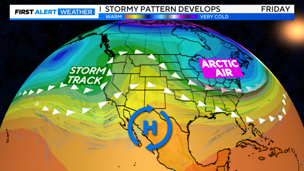
Behind the ridge, a storm track lines up to the west with our first storm arriving Friday night into early Sunday and a second storm Sunday night through Tuesday.
These incoming storms will be warmer - meaning snow levels will be generally high across the Sierra, and many across the foothills will end up with mostly rain.
Snow levels will fluctuate between each storm, but the impacts will be similar.
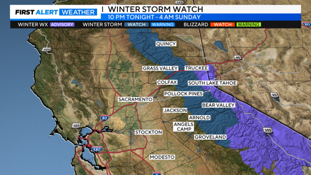
A Winter Storm Watch is in effect Friday night through Monday night for areas above 6,000 feet, including Donner Summit, Echo Summit, and HWY 88 over Carson Pass.
The Lake Tahoe basin including Truckee and South Lake Tahoe are under a Winter Weather Advisory starting Friday night.
STORM #1
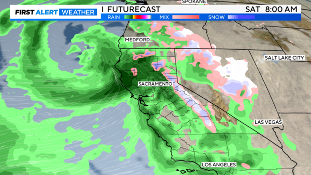
Our first storm moves in through the day Friday with the first wave of rain moving across western portions of the valley by late Friday morning. Rain becomes heavy across northern portions of the Sacramento Valley and foothills at first before filling in.
Snow begins across the Sierra through the afternoon, yet snow levels will be high. Generally above 6,000 to 6,500 feet as this storm moves in.
For the Valley, the heaviest rain rates will be Friday afternoon and night and across the mountains Saturday morning.
Rain totals from this first storm will be generous for higher elevations with 1'' to 3'' possible. Across the valley, expect 0.50'' to 1''.
With higher snow levels, snow accumulation will be best over our mountain passes and over higher peaks. Still enough to cause chain controls, and delays if traveling over the passes.
By Saturday, rain and snow showers become more scattered in activity. We will have 'some' dry time during the evening, but active weather sticks around.
Saturday will be breezy too, with 15-20 MPH winds through lower elevations and 25-35 MPH winds across portions of the mountains with gusts up to 50 MPH. This ushering in our next storm as it arrives on Sunday.
STORM #2
These storms will be back-to-back, meaning while some may see a lull in activity, others may not.
Our next storm will have moved in by the time we wake up on Sunday morning. This storm will be stronger and pack more rain and snow chances into it.
Repeating the pattern of our first storm, this storm starts off along the west side of the Valley and in the mountains. By the afternoon, filling into the Valley and down the Sierra. There may be a few breaks in the rain, but expect Sunday to be mostly wet during the day.
This will be another warmer-type storm, helping snow levels increase 6,500 to 7,500 feet by Sunday night, but return to 6,000 to 7,000 feet Monday. Snow will be heavy over the passes and we may see areas of low visibility with gusts up to 30 MPH. Make sure you're prepared for winter travel and delays if you have to go over the Sierra.
Rain will become the heaviest Sunday evening into Monday morning. Expect slick roads, a longer commute, and possible flooding on streets in poor drainage areas.
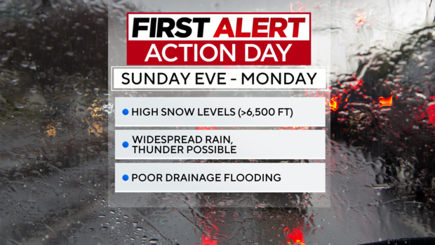
Monday will be a First Alert Action Day as widespread rain fills in just in time for the morning commute. A few thunderstorms may be possible through the valley with just enough instability around.
Monday's activity will bring an increase in the potential of flooded water on roads, flooding of low-lying areas, increased stream levels and flows, mud and rock slides.
Rain and snow continues into Monday evening and Tuesday as the back end of the storm moves in.
Showers begin to taper as we get into Tuesday.
RAIN TOTALS
Adding up the rain over this active stretch, many in the valley will end up with at least an inch of moisture if not up to 3''' by Tuesday.
Each of these storm systems will focus across the foothills, especially areas north of I-80. Nevada to Plumas counties could get about 3'' to 6'', meanwhile to the south, El Dorado to Tuolumne counties could get around 2'' to 5''.
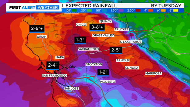
Beneficial moisture indeed but may bring problems as it adds up in the span of a few days. Flooding risk may increase.
SIERRA SNOWFALL
As these storms pass, be prepared for changing conditions across the Sierra. Chain controls, delays, closures, and snow-packed roads may become an issue.
Snow totals will climb towards the end of the weekend into Monday. For areas above 7,000 feet, they could end up with 1-3 feet of snow by Tuesday.
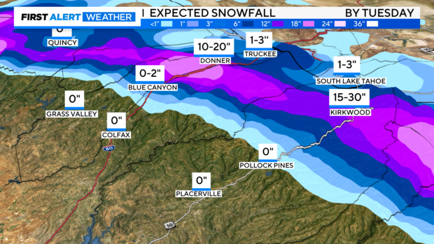
Towards the passes is where we expect to see the best accumulation. Around Donner Summit and Echo Summit, 10 to 20'' could be possible.
Lower portions of the Sierra, such as Blue Canyon, Truckee and South Lake Tahoe, can expect to see up to 3'', but most will fall as wet snow. Below 6,000 feet, expect mostly rain.
A bit further south towards Kirkwood, 15 to 30'' could be picked up, especially across the ski area's high peaks.
A LOOK AHEAD
By next Tuesday, our weather begins to dry out. During the middle of the week, a ridge of high pressure starts to rebuild giving us a break in the wet weather.
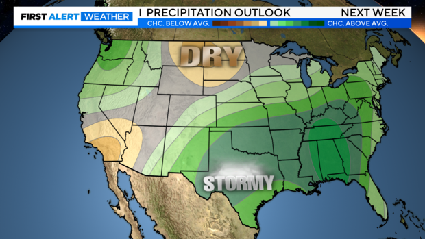
NOAA's Climate Prediction Center keeps most rain chances to the north. With a slightly drier trend from the Central Valley to southern California.
We'll keep an eye on this trend as we get closer to see if any storms slip into our area. Make sure to stay with the CBS Sacramento First Alert Weather team for any new updates.


