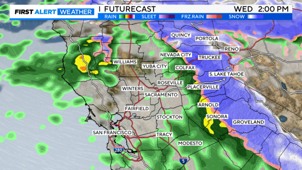
Snow activity to increase throughout Wednesday; Sierra travel will be difficult to impossible

Snow chances across the Sierra continue to increase this week with several storm systems lining up to help California's lagging snowpack.
A quick cold front passed through Northern California on Tuesday morning, delivering light rain across our low elevations and snow across mountain passes. The snow was just enough needed to issue chain controls on I-80 during the Tuesday afternoon's commute.
Snow activity increases through the day Wednesday with another round of heavy snow and gusty wind on the way. Wednesday will be a First Alert Action Day for the foothills and Sierra as travel will be difficult to impossible.
Wednesday's Impacts
Snow picks up in intensity and impacts Tuesday night through Wednesday evening. The heaviest period of snow will be during the day Wednesday. Snow rates of 1-3'' per hour will be possible over the Sierra from 10 a.m. to 6 p.m. on Wednesday.
This system will bring another round of colder air with highs only in the 20s across the Sierra, which will help lower snow levels down to 2,000 feet at times.
Travel impacts are expected to be major with 1 to 3 feet of snow falling across the Sierra. Along with heavy snow, gusty winds will bring low visibility and blizzard conditions. Avoid travel if possible on Wednesday.
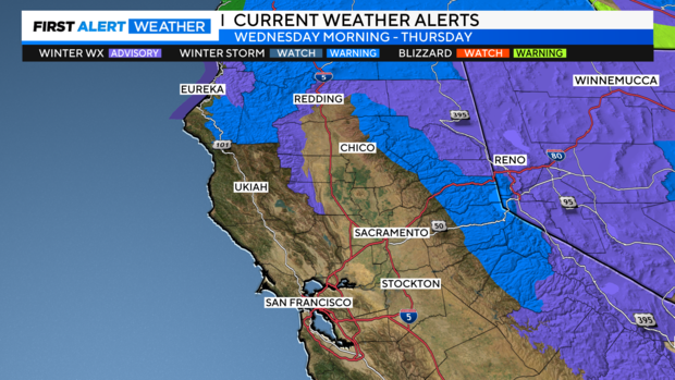
A Winter Storm Warning and Winter Weather Advisory are in effect for areas above 3,500 feet starting early Wednesday through Thursday morning. Travel could be difficult with chain controls and possible road closures.
Wind over I-80 and Highway 50 passes could reach 45 to 50 miles per hour, but over mountain ridges, wind gusts could approach 90 to 100 miles per hour. Expect several ski areas to close upper mountain lifts with the strong wind.
The latest model runs have slowed the storm through Wednesday evening, which means we could see the heavier snow sticking around a bit longer. Snowfall amounts have increased as of Tuesday morning because of this trend.
Snowfall Totals
Like last weekend's storm, this storm will bring more powder-like snow, but not as moisture-dense to weigh down trees and powerlines. However, totals may be impacted thanks to the fluff it has and the wind that may blow it around to different areas.
That being said, there will be enough time for a lot of snow to accumulate fast.
Here's what we are thinking from Tuesday through Wednesday:
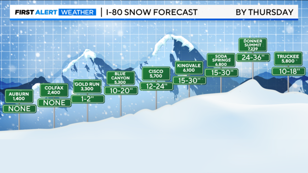
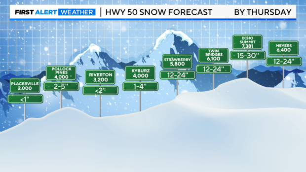
Above 4,000 feet in elevation, 1 to 3 feet of snow is expected. The heaviest snow will be across mountain peaks and passes. Areas like Donner and Echo Summit could see up to 36" of snow.
Areas 2,500 feet and lower could see some snow, but most areas will get rain. If anything accumulates, expect less than 1''.
Valley Rain
Adding on to the light rain we picked up Tuesday morning, a little more is expected on Wednesday – but amounts will be light.
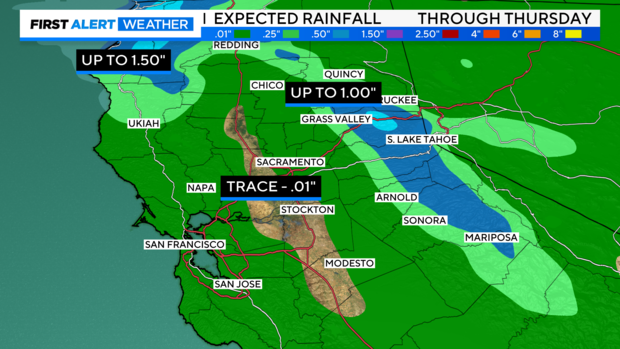
Through the valley, a trace of 0.10'' will be common. Closer to the foothills, amounts climb to 1''. Toward the northwest coast, up to 1.5'' of rain will be possible through Thursday.
Rain will be enough to make roads slick through your commute on Wednesday.
More weekend rain and snow
Tuesday through Wednesday's storm clears out by Thursday morning. Temperatures on Thursday will start off cold with lows in the 20s and 30s. Dry weather sticks around through the day and into most of the day on Friday.
By Friday night, our next storm moves in. This looks to pack better rainfall for the lower elevations, gusty wind and more snow for the Sierra, yet amounts will be less.
This storm will be on the warmer side compared to the mid-week one. Snow levels are initially around 3,000 to 5,000 feet early Saturday, rising to 4,500 to 6,000 feet Saturday afternoon-night.
Rain and snow linger into Sunday morning before clearing out through the day.
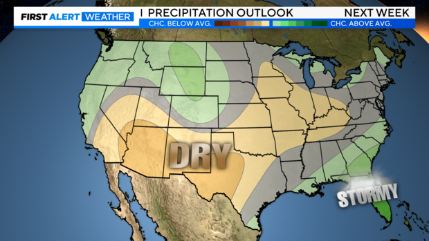
Long Range Outlook
The long-range models continue to show high-pressure building over the West Coast into next week. The drier pattern that sets in Sunday should continue at least through next Tuesday, January 16.
NOAA's Climate Prediction models are keeping rain in the forecast for Northern California Tuesday through Wednesday of next week. However, models have been inconsistent with timing and who gets the bulk of the precipitation.
Make sure to stay with the CBS Sacramento First Alert Weather team for the latest on what to expect and if a drier trend stays around.


