After Monday's tornado warnings, more rain and snow expected across Northern California

A storm system that began moving in this weekend brought heavy snow and rain to Northern California on Monday and is expected to linger through much of the week.
This storm system has been stronger than the region's previous, also bringing gusty winds and severe thunderstorms – and even tornado warnings.
Rain and snow over the next few days
Scattered showers, storms, and snow across the Sierra continue through Monday night into Tuesday. We'll keep the rain chances in place through early Wednesday, but the bulk of the storm will have passed.
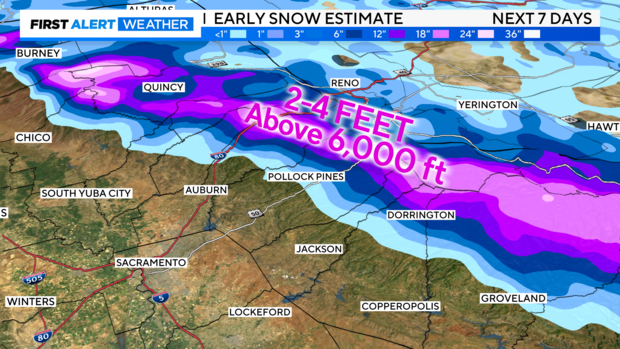
If we combine rain and snow amounts over the next seven days, here is what we're expecting.
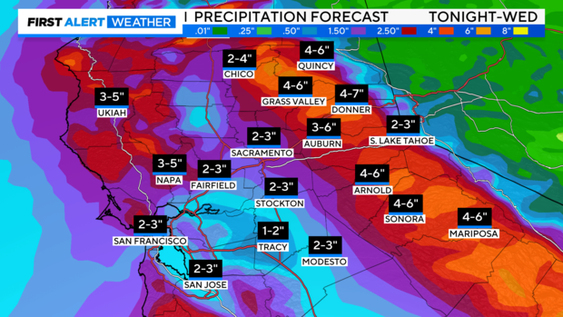
Rain estimates bring a general 2-3 inches of rain to the valley. Amounts trend higher across the northern Sacramento Valley and Bay Area, with up to 4 inches of rain possible through next Wednesday.
Hardest-hit spots in the foothills could receive 4-7 inches of rain by Wednesday.
Across the Sierra, we're expecting 2-4 feet of snow over the next few days. Snow levels will mainly stay around 5,000 feet as storms will be warmer. Heaviest snow will be above 6,000 feet.
Drier weather returns as we get closer to Thursday and Friday of next week. Highs over the next several days will be in the upper 50s to the low 60s as we get closer to the end of February.
Through this active weather stretch, make sure to stay with CBS Sacramento's First Alert Weather Team for any updates to the forecast.
Recap of Monday
Intense snow and gusty winds created blizzard-like conditions across the Sierra on Monday. A Winter Storm Warning has been issued.
While heavy snow fell in the Sierra, rain was heavy in various areas across the region. Some areas, including in Sacramento, saw minor flooding — and even a sinkhole.
A short break in rain showers during the late morning led to more instability in the atmosphere, fueling stronger afternoon weather.
These storms brought strong wind gusts and a chance of tornadoes throughout Northern California.
The National Weather Service's Storm Prediction Center had forecasted a 5% chance of isolated tornadoes across portions of the Sacramento Valley and Central Valley, including Sacramento, Stockton, Modesto, Yuba City, Roseville and Elk Grove, placing us in the slight category, which is a level two of five.
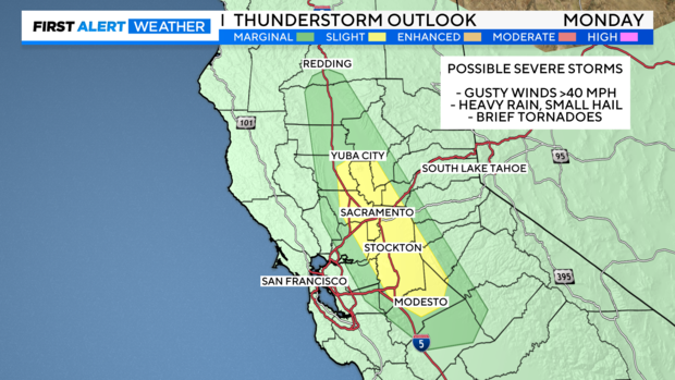
The last time the Storm Prediction Center forecasted a severe weather risk like this in the Sacramento Valley was in February 2015.
Late Monday afternoon, the NWS Sacramento issued a tornado warning for southwestern Plumas County and eastern Butte County in Northern California. The warning expired at 4:30 p.m.
As of 9 p.m., there were no reports of a tornado touching down.


