Back-to-back storms set to bring heavy rain, snow to Northern California

Many of us are still drying out after a quick-passing storm on Valentine's Day that brought rain and snow to the region. This storm is not the only one we have, as back-to-back storms move in this weekend.
Your travel window across the Sierra will be closing after Friday night as storms tap into two atmospheric rivers bringing us lots of moisture over the next few days.
Rain moves in on Saturday
Rain picks up through the day Saturday, with the heaviest rain moving in Saturday afternoon and evening as storm number two this week arrives.
This storm will have similar impacts as storm number one, with rounds of heavy rain and gusty winds. It will be better to make plans indoors than outdoors for President's Day weekend.
As the cold front moves in, rain will pick up in intensity and wind gusts up to 40 MPH will be possible through the Valley. Closer to the Sierra and foothills, expect the bulk of rain and snow to arrive through the evening.
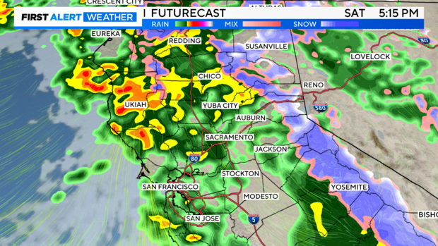
Many of us could get 0.50-1'' of rain by the time we reach Sunday morning.
This storm will be warmer, meaning snow levels will be higher. Snow levels will start at 6,000 to 7,000 feet on Saturday before lowering to 5,000 feet on Sunday. The heaviest snow for the Sierra arrives on Saturday night.
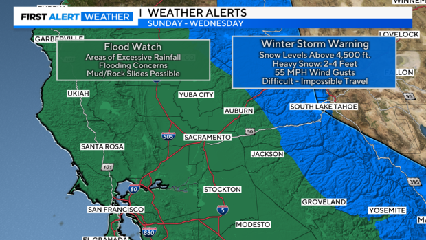
Expect travel impacts with slick roads, chain controls and delays. A Winter Weather Advisory has been issued as those above 5,000 ft. have the chance of 4-12'' of snow by Sunday.
This will be a very fast-moving storm system and quick to clear by Sunday morning. Giving us a little break to run errands during the morning and early afternoon before storm number three arrives.
Slow-moving storm to arrive late Sunday evening
The third storm isn't expected to arrive until late Sunday evening into Monday morning. This one looks to pack a punch to Monday morning's commute, with heavy rain expected.
This storm is expected to be slow-paced as low pressure near the coast slowly moves to our south, producing rain through Wednesday before clearing out.
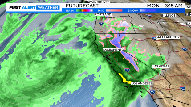
Timing it out, rain will pick up late Sunday night into early Monday. Monday will be a wash-out type of day with heavy rain, gusty winds and isolated thunderstorms expected.
Rain increases in intensity, and we could see rainfall rates climb to 1'' an hour across portions of the region.
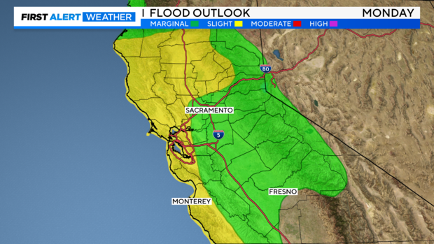
After several days of rain, flooding will be a concern, especially on Monday. Localized flooding on roads will be likely and across low-lying areas along creeks, streams and rivers can not be ruled out.
Snow across the Sierra will also pick up in intensity by Monday. Travel across the Sierra will be difficult to impossible with heavy snow and gusty winds creating blizzard conditions. Travel is strongly discouraged. A Winter Storm Warning has been issued.
Monday will be a First Alert Action Day as the bulk of this storm moves in.
A Flood Watch has been issued Sunday through Monday for the entire valley, foothills, delta and Bay Area.
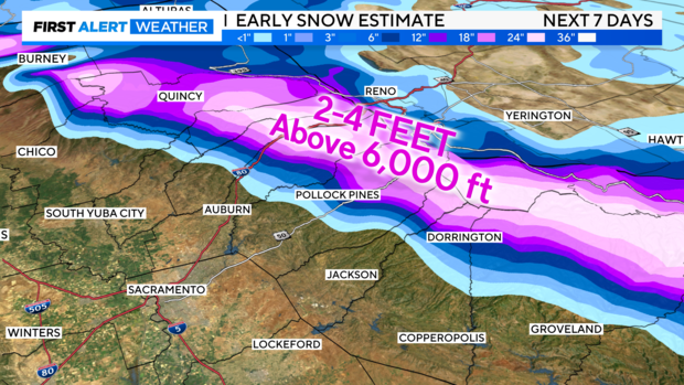
If we combine rain and snow amounts over the next seven days, here are early estimates we're expecting.
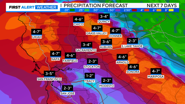
Rain estimates bring a general 2-3 inches of rain to the valley. Amounts trend higher across the northern Sacramento Valley and Bay Area with up to 4 inches of rain possible through next Wednesday.
Hardest-hit spots in the foothills could receive 4-7 inches of rain by the middle of next week.
Across the Sierra, we're expecting several feet of snow within the next seven days. Snow levels will mainly stay around 5,000 feet as these incoming storms are on the warmer side.
As mentioned, this storm will be slow-paced, keeping rain in the forecast on Tuesday and Wednesday, yet showers will be scattered and less organized.
Drier weather returns as we get closer to Thursday and Friday of next week. Highs over the next several days will be in the upper 50s to the low 60s as we get closer to the end of February.
Through this active weather stretch, make sure to stay with CBS Sacramento's First Alert Weather Team for any changes to the forecast timing and amounts.


