First Alert Weather: Strong atmospheric river bringing heavy valley rain, Sierra snow, and impacts midweek

After a quiet weekend, another round of wet weather returns Wednesday bringing several impacts to Northern California.
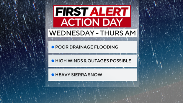
Our next storm will bring heavy rain, Sierra snow, strong winds, flooding concerns and thunderstorms. Wednesday through Thursday morning will be a First Alert Action Day for the region as this storm moves in.
Mid-week storm
Wednesday morning starts off quiet for most with increasing clouds and mostly dry weather through the morning commute.
Our storm begins to move in along the coast before reaching the Valley by the afternoon.
RELATED: Northern California residents prep for this week's wet weather. Here are sandbag locations
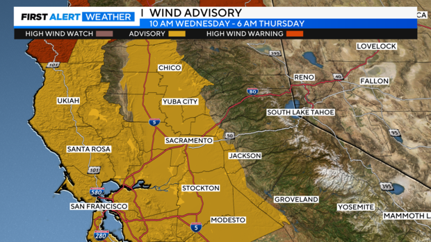
As this storm moves inland, wind will increase through the evening with gusts up to 45 - 55 MPH across portions of the Bay Area, Delta, valley and foothills. Some downed trees and power lines are possible. A Wind Advisory has been issued.
This storm will not only bring an extra punch in wind, but moisture too. The storm will tap into a moderate-strong atmospheric river, also referred to as the Pineapple Express, a narrow band of water vapor funneling in warm moisture originating from Hawaii.
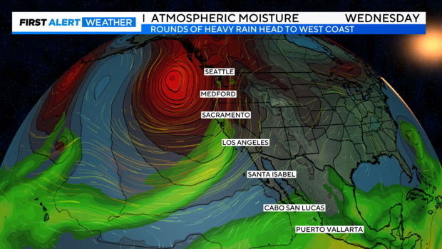
This moisture will act as a boost increasing rainfall rates from Wednesday evening through Thursday morning. Some areas may receive up to a half-inch an hour.
The heaviest precipitation falls after midnight into Thursday morning with scattered showers Thursday afternoon that could linger to Friday evening.
Rounds of moderate-to-heavy rainfall will likely lead to flooding in small streams and creeks and ponding on roadways and low-lying areas.
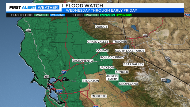
A Flood Watch remains in effect for the delta, valley and portions of the foothills from early Wednesday morning through early Friday morning.
There will also be enough instability present for the development of thunderstorms on Thursday and Friday. Any thunderstorms that develop will be capable of lightning, small hail, brief heavy rain, and gusty winds.
Rainfall by Friday
The brunt of this storm will focus along the North Coast, Bay Area and Coastal Range. Some along the coast will pick up 2-4'' of rain by Friday morning. Further north, closer to Ukiah, 4-6'' of rain is expected.
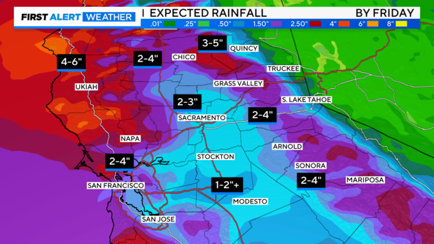
Further inland, impacts will be similar.
Approximately 2-3'' of rain is expected from Sacramento toward up north. Toward the Central Valley, 1-2'' of rain. Across the foothills, 2-4'' will be expected for most. Further north towards Nevada and Plumas County, 3-5'' of rain will be received by Friday.
Sierra snow
A few showers could reach the mountain during Wednesday afternoon, but most of the precipitation holds off until the evening.
Snow levels still look to start around 6,000-7,500 ft. Wednesday evening, and then fall overnight into Thursday morning to 5,000 feet.
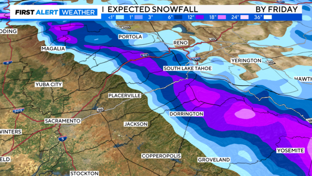
Snowfall rates will begin to increase Wednesday night through Thursday morning. Travel over the passes will be tough to impossible with heavy snow and gusty winds.
Southerly winds will gust up to 80-90+ mph over mountain ridges, up to 50-60+ MPH across mountain passes.
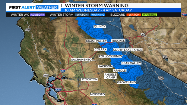
A Winter Storm Warning remains in effect from Wednesday morning through Friday morning for elevations above 5,000 feet.
Snow continues through the day Thursday into early Friday morning, however, most of our moisture will be tapering off. Snow levels will be even lower on Friday morning, down to 3,500 feet with more cold air present.
Two-day storm totals are expected to bring 1-2 feet of snow at pass level and up to 3+ feet for mountain peaks.
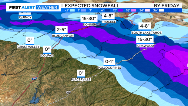
Closer to 4,500 - 5,000 feet expect 2 to 5 inches of snow. Under 4,000 feet expect up to an inch.
Chain controls, closures, and delays will be expected across the Sierra. Make sure to be prepared for winter travel.
Break between storms
Heading into Saturday, we'll get a brief break in between storms.
There will be a few scattered showers around, yet most of us will be drier, returning to partly sunny skies. Highs in the low 50s.
This will be the best day of the weekend to run errands.
More storms next week
Our weekend break is short-lived as another storm arrives Sunday into Monday bringing more rain and Sierra snow.
Another round of steady rain with rainfall increasing through the Sunday afternoon-evening. This storm will bring similar impacts as our mid-week storm. Sunday will also be a First Alert Action Day.
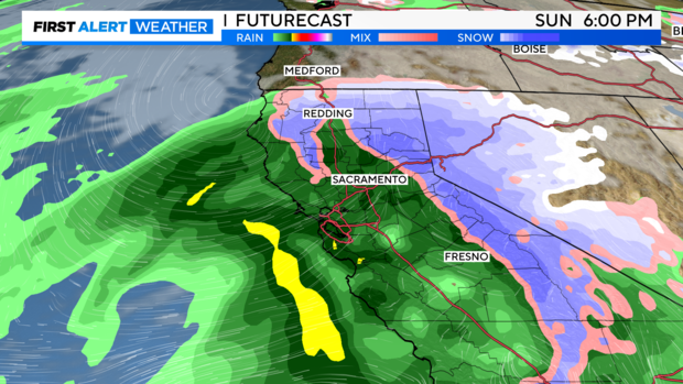
Snow levels continue to remain low at the start of the event around 3,000 to 3,500 feet then slowly rise in the late afternoon and evening hours but remain lower than pass level.
Rain and wind look to stay around through Monday. A brief break Monday night with more scattered showers, before more rain moves in next Tuesday.
We are still about five days out and models could change. Yet, be prepared for more rainy and unsettled weather over the next several days.
Make sure to stay with the CBS Sacramento First Alert Weather team for updates on incoming storms.


