First Alert Weather: NorCal storm forces evacuations, fallen trees and power outages
CBS Sacramento is calling Tuesday a First Alert Action Day.
Tracy road closures still in place
Multiple road closures were still in place due to flooded roads in Tracy. Those are:
- Lehman Road south of Linne
- Corral Hollow Road, two miles south of I-580
The South San Joaquin County Fire Authority said Corral Hollow Creek was still within its banks at Chrisman Road, though, it is being monitored in case any other closures need to be put in place.
Kayaker in critical condition after water rescue
Sacramento Metro Fire said crews had to rescue a kayaker who went missing in the water in the American River on Tuesday.
Metro Fire said the person was not wearing a life jacket while on the river. After being located, the individual was taken to an area hospital in critical condition.
As of 9:20 p.m., there was no update on their condition.
Driver ignores road closure, crashes
The California Highway Patrol Tracy said a driver went through a road closure on Kasson Road near Tracy and crashed into a ditch.
According to the CHP, the driver hit a puddle and hydroplaned.
The driver was issued a citation.
PG&E outages in Sacramento region
The utility company said more than 3,800 customers were without power across its Sacramento division Tuesday night. A majority of the impacted customers were in Knights Landing and Davis.
In the Sierra division, there were more than 2,400 customers without power, with most being in the Grass Valley area.
In the Stockton division, which includes the foothills, more than 1,600 customers were without power, with most of those customers being in Jackson and Valley Springs.
PG&E said crews were working to restore power to all customers as soon as possible.
Mudslide hits home in Colfax, evacuations ordered
Cal Fire NEU said a mudslide struck a Colfax home along Ben Taylor Road.
No injuries were reported and all occupants of the home were accounted for.
Three homes along Ben Taylor were told to evacuate while an evacuation warning was issued for homes along Alpine Way.
See video from the scene below.
Thousands without power in South Lake Tahoe
The City of South Lake Tahoe said approximately 4,599 residents were without power.
The utility company in the area, Liberty Utilities, projects a full restoration by 7:52 p.m. for the Meyers area. There is no expected time of restoration for the remaining impacted areas.
Sacramento County power outages
SMUD said more than 1,100 customers were without power countywide as of 5:20 p.m.
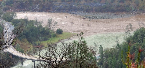
Evacuation warning along Sacramento River in Sutter County
The Sutter County Sheriff's Office issued a mandatory evacuation order for Lovey's Landing RV Park along the Sacramento River due to rising water levels.
The order is only for the RV park, which is located near Colusa, and is effective immediately.
According to the sheriff's office, the river is expected to rise above the 65-foot elevation at the Colusa Bridge by Wednesday morning. Historically, that is when the trailer park begins to flood.
Your photos
Do you have weather photos and video to share? Go here to send them to us: https://app.cimediacloud.com/file-request/9XIN0RIZ#/
Rock slide in Placer County
Crews were working to clear a rock slide at Old Foresthill Road and Foresthill Road, just east of Auburn.
Placer County officials said the road is closed for safety purposes and an update should be provided Wednesday morning.
Observing conditions over eastern Stanislaus
A convective band is developing over far eastern Stanislaus, Calaveras and Tuolumne counties. This may increase the flood risk in the the foothills with funnel clouds being possible.
I-80 chain controls lifted
Chain controls have been dropped on Interstate 80 over Donner Summit.
Water rescue successful in north Sacramento
Rescue crews got two people out of a flooded drainage ditch in North Sacramento.
Two adults and a dog were reportedly trapped in a makeshift shelter. Crews had to use boats to rescue them.
The scene was near Natoma Street and Tenaya Avenue.
Sacramento Fire says, due to the wind, a helicopter wasn't able to help in the situation.
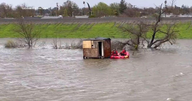
No injuries were reported.
Modesto power outages
Several areas in Modesto are experiencing weather-related power outages, officials say.
The Modesto Irrigation District says the following areas are in the dark:
Empire (a neighborhood off of Standiford and Tully), Kiernan (between Dale and Tully), and Rose Avenue, Wylie Drive, Scenic Drive and Oakdale Road.
No estimated time of restoration has been given, but Modesto officials say crews are working on the issues.
Wind gusts picking up
Gusty winds are now moving through the Bay Area.
In San Francisco, a wind gust of 74 mph was recorded just before noon.
The Sacramento area is also getting some strong gusts, with Mather recording a 53 mph gust and Sacramento International Airport seeing a 51 mph gust around noon.
Sacramento County parks closures continue
Parks in the Sacramento region are remaining closed for the rest of the day due to high winds. At the National Weather Service's office in Sacramento, there have been gusts as strong as 50 mph in the 11 a.m. hour.
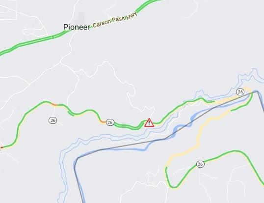
Hwy. 29 in Amador County blocked
State Road 26 in Amador County is blocked in both directions due to fallen trees at Defender Grade Road.
There is no estimated time for the roadway opening back up. You can get the latest road status updates at quickmap.dot.ca.gov.
Strong winds on the way
Forecasters say strong and potentially damaging winds are still expected to arrive on Tuesday.
According to the National Weather Service, winds will be picking up through the morning. Gusty winds will be expected into evening, where gusts could be around 50-60 mph in the valley and over 70 mph in the high country.
Chain controls back in effect
California Highway Patrol says chain controls are now in effect on Interstate 80 in the Sierra.
Flood Warning issued for the Middle Fork Feather River near Portola
The river is expected to rise into moderate flood stage late Tuesday, cresting at 4854'.
At 4,854 ft. moderate flooding is possible of lowlands, roads, homes, businesses and structures along the river from Beckwourth to Clio. The lowest homes on West Street begin to flood. Impacts below Portola are influenced by the magnitude of tributary flows, especially Sulphur Creek.
Part of I-5 flooded in Lathrop
Caltrans said the southbound Interstate 5 connector ramp to eastbound Highway 120 was flooded Monday night. This has forced a closure and there is no estimated time for the reopening of the roadway.
Sierra ski resorts closed Tuesday
Palisades Tahoe said lift operations would be closed Tuesday due to high winds, increased avalanche danger, high snow and flooding effects.
Work to reopen the mountain to guests will occur once the storm passes.
The resort said it expects to receive 26-33 inches of snow at mountain elevations above 8,000 feet, 7-26 inches at mid-mountain elevations, and 3-7 inches at the base level.
Additionally, wind gusts are expected to exceed 100 miles per hour over ridgelines.
Over at Heavenly Mountain Resort, officials said The Gondola and top of Gondola lifts and facilities would also be closed Tuesday — also for weather.
Amador County prepping for potential evacuation warnings
Amador County said a flood evacuation warning may be issued overnight or early Tuesday morning depending on the levels of local creeks and riverbanks.
The warning would not mean residents should evacuate, only that they should be ready to evacuate once told to do so.
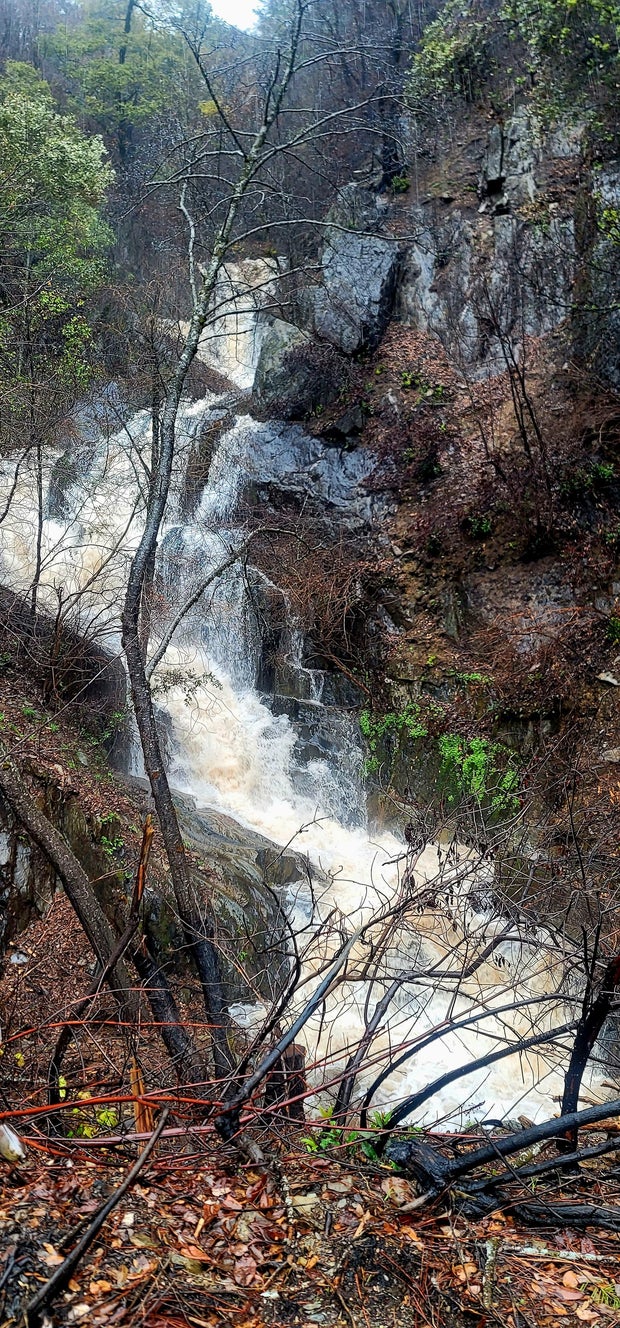
Heavy rainfall Monday night into Tuesday is expected to significantly increase water levels around the region, bringing the potential for widespread flooding, not just in Amador County.
Amador County said the following areas are of the most concern:
Jackson - Clinton Rd, South Av, Gordon Ln, Marcucci Ln, Pitt St, Water St, Main St, North Main St and Jackson Gate Rd
Sutter Creek - Church St, Main St, Badger St and Spanish St
Ione - Main St, West Marlette, Springcreek Dr, West Jackson St, Eagle Dr and Edgebrook Dr
Amador County - Clinton Rd, Sutter Creek Volcano Rd, Highway 88 east from Jackson to Previtali Rd
The warning would be issued via CodeRED. The county said residents could sign up for alerts here.
Hail storm in Wilton
CBS13's Steve Large captured video of a hail storm in Wilton on Monday. See the video below.
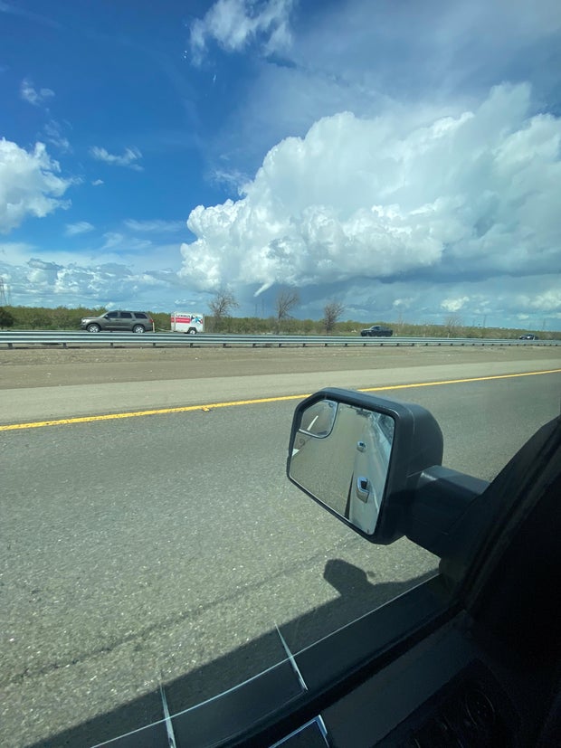
Funnel cloud spotted in San Joaquin County
CBS13 obtained a photo of a funnel cloud near Tracy and the community of Mountain House.
It happened at around 1:57 p.m.
Despite this, there have been no reports of it touching down. See a photo of it below.
Some Sacramento County parks to stay closed ahead of storm
Sacramento County said some regional parks that have already been closed will stay closed until further notice, while others will see delayed openings Tuesday as another storm is expected to arrive in the region by Monday night.
On Tuesday, all regional parks will have their openings delayed until noon so crews could prepare for and examine the impacts of the storm. Heavy rain is expected with wind gusts exceeding 50 miles per hour.
Previous storms have left soil saturated, meaning those strong wind gusts have the potential to knock down trees countywide.
The following parks have been closed since March 8: Discovery Park, Northgate, Howe River Access, Watt River Access, Gristmill Gravel Bar and Sailor Bar boat launch. All will remain closed indefinitely and others may also see extended closures depending on the damage left behind by the storm.
Solano County issues flood, wind watches
With the next major storm set to arrive in Northern California Monday night, a flood watch is in effect in Solano County until 10 a.m. Wednesday.
A high wind watch will also be in place for 24 hours beginning at 11 p.m. Monday,
Local authorities said communities should expect heavy rain, strong winds and possible power outages.
Fairfield police said sandbags are available at the Fairfield Corporation Yard at 420 Gregory Lane through Friday, between 8 a.m.-4 p.m. Residents can also get sand at the southeast corner of Allan Witt Park off Woolner Avenue and Pittman and Cordelia Roads intersection.
Residents can report downed trees or flooding by calling (707) 428-7407 during regular business hours or call the police station's non-emergency number at (707) 428-7300, option 8.
West Sacramento boat ramp closed
The City of West Sacramento said the Broderick Boat Ramp and Etensh Zeleke public boat dock were both closed to the high level of the Sacramento River.
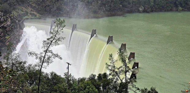
River levels high
City of West Sacramento officials are trying to calm people's nerves, saying that the river level is high but not expected to flood.
The Sacramento River is expected to rise even more the next few days.
West Sacramento public works crews are on standby for any issues that may arise, the city says.
Noon forecast
Tracy Humphrey timed out the storm at noon Monday.
Thunderstorms developing Monday
CBS Sacramento is calling Monday and Tuesday First Alert Action Days.
Here are some details:
- Thunderstorms will be developing in the Valley Monday from noon until 8 p.m.
- Clearing in the Valley and subsequent heating are trigging the thunderstorms.
- Storms may contain hail, downpours
- Rain and strong winds will move into the region Monday night and into Tuesday
- Damaging winds gusting to 45-55 mph
- Renewed flash flooding concerns in the foothills
- Funnel clouds are possible in the northern region of the valley.