Tropical Storm Laura batters the Caribbean and the U.S. Gulf Coast could be next
Two tropical storms were headed toward the Gulf Coast on Monday. Marco and Laura could hit just a few hundred miles apart within 48 hours of each other — and forecasters believe Laura could become a Category 3 hurricane when it makes landfall. Residents in low-lying areas have been ordered to evacuate.
Marco made landfall on Monday near the mouth of the Mississippi River, where it's producing a small area of tropical storm-force winds that are expected to subside in the next few hours. The storm had strengthened to a hurricane Sunday, but has since weakened to a tropical storm — and it's expected to calm to a tropical depression by later Monday night.
Meanwhile, Laura, which battered the Dominican Republic and Haiti, leaving millions without power and killing at least 11, is expected to hit the U.S. by Wednesday evening or Thursday. Forecasters expect the storm to bring widespread flooding and life-threatening storm surge. A hurricane warning is in effect from Port Bolivar, Texas, to west of Morgan City, Louisiana.
The storms were heading for the U.S. ahead of the 15th anniversary of Hurricane Katrina devastating New Orleans. Louisiana Governor John Bel Edwards said the window between the two storms could be as slim as 12 hours — and it comes amid the coronavirus pandemic, an added challenge as people leave their homes and head to shelters.
"I just feel afraid that I'm going to lose my house, and I don't have anywhere to go right now, especially with the virus," a woman told CBS affiliate WWL-TV.
Marco was falling apart as it headed toward the Gulf Coast, but authorities were concerned about Laura because it was expected to gain strength from the warm waters of the Gulf. "We're only going to dodge the bullet so many times. And the current forecast for Laura has it focused intently on Louisiana," Edwards said during a press conference.
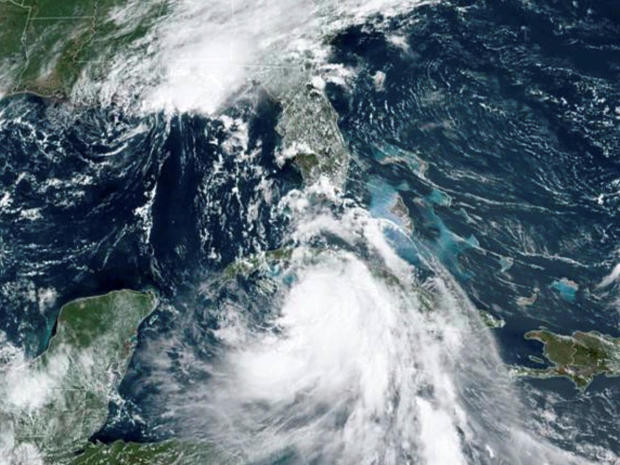
As of 8 p.m. ET, Laura was about 140 miles east of the western tip of Cuba, with maximum sustained winds of 65 mph, and the storm was moving west-northwest at 20 mph, according to the hurricane center. Forecasters expected it to move over the southeastern Gulf of Mexico on Monday night.
Laura was expected to strengthen into a hurricane Tuesday and become more powerful Wednesday.
Since Hurricane Katrina, everyone in the area is more sensitive to any kind of storm coming this way. One shelter in a low lying Plaquemines Parish was filling fast even amid concerns over the coronavirus pandemic.
Theresa Frantz and her daughter left their home while others stayed behind.
"So I got two family members down there that we don't know if they gonna make it," Frantz told CBS News.
Janet Shamlian contributed to this report.