Double threat: Hurricane Idalia and Hurricane Franklin lurk off southeast U.S.
Update: Read the latest forecast and warnings for Hurricane Idalia here.
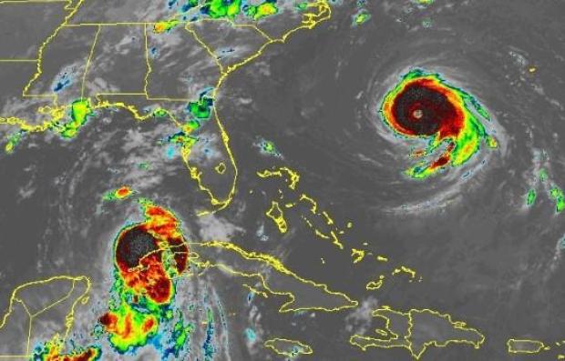
Two hurricanes were off the southeastern U.S. Tuesday as the Atlantic hurricane season was getting into full swing. Hurricane Idalia was off the coast of Cuba on a potential track to come ashore as a major hurricane over the Florida Gulf Coast, the National Hurricane Center said.
At a Monday news conference, Florida Gov. Ron DeSantis told residents to prepare for "major impacts" on the Gulf coast.
"We do expect Hurricane Idalia to be a major hurricane that will strike the state of Florida," he said.
President Biden spoke with DeSantis earlier Monday and approved an emergency declaration for the state, the White House said.
Idalia was forecast to develop into a major hurricane over northeastern Gulf of Mexico by early Wednesday," the center said, adding that it could would likely reach Florida's Gulf coast Wednesday, as well.
The center pointed out that "life-threatening storm surge and dangerous winds" from Idalia are "becoming increasingly likely for portions of Florida."
Major hurricanes are usually a Category 3 and up on the five-level Saffir-Simpson scale — storms that the NHC says can cause "devastating" and "catastrophic" damage.
Hurricane Franklin strengthened into the first major hurricane of the Atlantic season and was a powerful Category 4 early Tuesday packing 140 mph maximum sustained winds.
Franklin was causing "life-threatening surf and rip current" along the U.S. coast, the hurricane center said, but it is not forecast to make landfall and will stay out to sea.
Florida casts wary eye on Idalia
Along a vast stretch of Florida's west coast, up to 11 feet of ocean water could surge on shore, raising fears of destructive flooding.
CBS News senior weather and climate producer David Parkinson says storm surge "is a serious threat with the worst areas getting a surge higher than a one story building, and that's likely from Cedar Key north along the Big Bend to Wakulla County."
Tampa Bay has "the potential for a 4-7 foot storm surge, including downtown Tampa at the river walk," Parkinson added.
Large parts of the western coast of Florida are at risk of seawater surging onto land and flooding communities when a tropical storm or hurricane approaches. That part of Florida is very vulnerable to storm surges, Jamie Rhome, deputy director of the National Hurricane Center, said Sunday.
"So it will not take a strong system or a direct hit to produce significant storm surge," he said. "So if you're anywhere along the Florida Peninsula, western Florida Peninsula, so let's say from about Fort Myers northward to the Panhandle, you've really got to be paying attention."
In Cedar Key, a fishing village that juts out into the Gulf of Mexico, a storm surge is among the greatest concerns, said Capt. A.J. Brown, a fishing guide who operates A.J. Brown Charters. The concern is that if the storm strikes Florida just to the north, Cedar Key would get the powerful surge that comes from being on the southeastern side of the storm.
There are worries in Cedar Key about a storm surge of two to five feet of ocean water, Brown said, and if the storm surge reaches five feet "it would cover most everything downtown."
At the popular Bridge Tender Inn in Bradenton Beach, a large tent covering the tiki bar area where musicians play might have to be taken down in preparation for Idalia, assistant manager Shannon Dunnan said Sunday.
"If we get a big storm that hits, it would probably rip that tent in half," she said.
But at this point, plans are for the establishment to stay open, Dunnan said.
Mexico's National Meteorological Service on Sunday warned of intense to torrential rains showering the Yucatan Peninsula, with winds as fast as 55 mph.
It said the storm could cause anything from powerful waves to flooding in southern Mexico, mainly around coastal cities in the Yucatán and Quintana Roo states. It asked citizens to stay alert.
Florida preparing
Florida emergency officials on Sunday urged residents to keep their vehicle gas tanks at least half-full in case they need to evacuate.
"This will ensure you can evacuate tens of miles inland to a safe location should the need arise," the Florida Division of Emergency Management said on social media.
Florida has mobilized 1,100 National Guard members, and "they have at their disposal 2,400 high-water vehicles, as well as 12 aircraft that can be used for rescue and recovery efforts," said DeSantis, the Republican governor who is running for the Republican presidential nomination.
"If you are in the path of this storm, you should expect power outages," he added. "So please prepare for that, particularly if this storm ends up coming in the Tallahassee region, there's a lot trees that are going to get knocked down, the power lines are going to get knocked down - that is just going to happen, so just be prepared for that and be able to do what you need to do."
Thirty-three Florida counties are under a state of emergency, the state emergency management agency said.
So far this year, the U.S. East Coast has been spared from cyclones. But in the West, Tropical Storm Hilary caused widespread flooding, mudslides and road closures earlier this month in Mexico, California, Nevada and points to the north.
The National Oceanic and Atmospheric Administration recently said the 2023 hurricane season would be far busier than initially forecast, partly because of extremely warm ocean temperatures. The season runs through Nov. 30, with August and September typically the peak.