Tornado season in overdrive: What's behind the extreme weather hitting the Midwest?
What started off as nothing more than an average tornado season has leaped into overdrive these past few weeks. Coupled with historic flooding in the nation's middle and all-time record-shattering heat in the Southeast, this extreme weather is being driven by an extremely amplified pattern — a pattern which bears the fingerprints of both natural climate fluctuations and global warming.
For the year so far, we are closing in on 1,000 tornado reports across the nation (960 as of May 28). That's more than 200 ahead of normal pace. Even for what is considered the heart of tornado season, the past 30 days has been exceptionally busy with over 500 tornado reports.
For the past few weeks, an abnormally large and prolonged cool pool of air has been locked in over the Southwest. These western U.S. dips in the jet stream, called "troughs," are a main ingredient in every severe weather season because they eject energy into the Plains states; that energy mixes with warmth and moisture from the Gulf of Mexico to spawn severe weather.
In recent weeks this pattern has been magnified for a few reasons. This amplification does not exist in isolation — the complex web of weather is interconnected all around the globe. Meteorologists call these links "teleconnections."
A couple of significant teleconnections are playing a part in our current severe weather pattern. The first is a natural multiweek cycle called the Madden Julian Oscillation (MJO). The other is an abnormally warm airmass over the Arctic and Alaska, which can happen naturally but in recent years has become more prominent because of human-caused climate change.
- What we know about tornadoes and climate change
- Surprising discoveries on how tornadoes form and how climate change could make them stronger
The MJO is an eastward-moving disturbance of clouds, rainfall, winds and pressure that traverses the planet in the tropics over a 30- to 60-day period. Pictured below is a depiction of the MJO wave moving eastward in the Indian and Pacific Oceans. The active phase, shown in blue over the western U.S. in late May, helps ignite and sustain severe weather across the United States.
Dr. Victor Gensini, an atmospheric and tornado researcher at Northern Illinois University, foresaw the recent burst of severe weather. "The latest rash of severe weather can be tied back to a strong Madden-Julian Oscillation (MJO) event that started in late April," he said, noting that the MJO reinforces the western U.S. trough and the resulting severe weather flowing from it.
Another prominent feature factoring in is an extremely amplified jet stream stretching from Alaska down to Mexico. The jet stream is a fast-moving river of air in the upper atmosphere that transports storms and separates cold air from warm air. Normally the jet stream flows from west to east with modest perturbations, but there is nothing modest about the jet stream the past few weeks. It's been oriented in an abnormally deep north-south trajectory, especially for late May.
Dr. Jennifer Francis is a senior scientist at Woods Hole Research Center who pioneered research into connections between global warming and the "wavy" mid-latitude jet stream. Francis says the remarkably persistent pattern of warmth in Alaska and a cold, snowy mountain West the past several months is related to the extremely amplified jet stream.
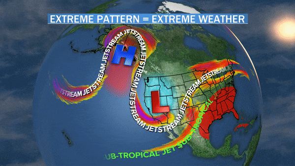
Pictured above is a "wavy" jet stream structure this past weekend, with a mountain of warm air in Alaska re-routing the jet stream far up into the Arctic. What goes up, must come down — in this case into California — displacing cold air over the southwestern U.S.
The connection is multi-dimensional, Francis explains: "It makes all kinds of sense that the very warm temperatures near Alaska, related to the low ice cover driven largely by global warming, must be boosting that [Alaskan] ridge, which in turn drives the downstream trough over the Western states that has caused late-season heavy rains in California, snow in Denver, and multiple pulses of extreme weather plowing through the Midwest."
Francis emphasizes that although it's difficult to say how much of a role any single factor plays, "these are exactly the types of long-lived patterns we expect to see happen more often as the Arctic warms and melts rapidly."
Now Francis's research is backed up by a brand new study published Tuesday in the journal Nature, which found the rapid decline of Arctic sea ice allows for an increased transport of heat and energy waves into the upper atmosphere. These waves deposit that extra energy, which disturbs the stratospheric polar vortex. That leads to a breakdown of this circulation and can translate into an extreme "wavy" jet stream.
The study comes from a team of researchers at the Alfred Wegener Institute, Helmholtz Centre for Polar and Marine Research (AWI) in Germany, who developed a climate model that uses machine learning to pair a global climate model with chemistry in the stratosphere. In doing so, the model can accurately replicate the observed undulations in the jet stream.
"Our study shows that the changes in the jet stream are at least partly due to the loss of Arctic sea ice. If the ice cover continues to dwindle, we believe that both the frequency and intensity of the extreme weather events previously observed in the middle latitudes will increase," Professor Markus Rex, head of atmospheric research at AWI, writes in an article on PHYS.org.
This extreme and prolonged pattern is also responsible for the disastrous flooding in the nation's heartland by pumping repeated heavy rain events over already saturated ground.
The western jet stream dip further compounds the extreme weather threat, in a domino effect, by helping enhance the record-shattering heat wave in the Southeast. And the interconnections do not end there; that same heat helped fuel the tornadoes near Dayton, Ohio on Monday, as pictured below.
While not drawing a direct line between climate change and this active severe weather, Dr. Michael Mann, a distinguished professor of Atmospheric Science at Penn State University, agrees with Francis that this type of heightened flow is consistent with what we'd expect of a warming climate. "This is certainly the type of persistent extreme weather pattern we have shown is being made more frequent by climate change," he said.
Gensini is more cautious in his attribution, saying, "We simply cannot say that this recent severe weather period was caused by climate change." Rather, he argues we must look at the longer-term trends. In a study this past fall, Gensini found a possible relationship between climate change and an increase in tornadoes spreading eastward into the mid-south and western Ohio Valley.
What concerns Gensini the most is compound impacts, when greater human vulnerability combines with projected increases in extreme weather. "Unfortunately we will continue to see disasters like Dayton... continue in the future due to a combination of potential forcing from climate change and increasing exposure due to changes in the human built environment," he said.