Hurricane Delta bears striking resemblance to Wilma, the Atlantic's most intense hurricane on record
Hurricane Delta strengthened at an incredible rate: more than 85 mph over 24 hours, reaching Category 4 on Tuesday before dropping back down to a Category 2. It was the fastest rate of intensification in the Caribbean since Hurricane Wilma in 2005, when that storm went from 75 mph to 185 mph in just 24 hours time.
Delta's rapid intensification is no coincidence. Memorable storms like this season's Hurricane Laura, and past season storms like Michael and Harvey, have done the same. Over the past few decades, rapid intensification has been increasing by about 3 to 4 mph per decade due to hotter waters from human-caused climate change. That means a system in 1980 that may have intensified by 40 mph in 24 hours might now intensify at 55 mph in 24 hours.
But Delta is looking especially similar to Wilma, the most intense storm on record in the Atlantic. And it could similarly have a catastrophic impact.
Delta is forming in the exact same place as Wilma, over a pool of the hottest water in the Northern Hemisphere. It is also forming at the same time of year, and both storm's eyes are tiny, "pin-hole" eyes.
The characteristics are contributing to an astonishing rate of intensification and the likelihood of catastrophic impact.
Delta exhibited a tell-tale sign of rapid intensification — a flare up of lightning in the center of the storm.
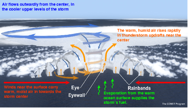
Lightning indicates rapid upward vertical motion and explosive thunderstorm development. Perhaps surprisingly, lightning is not very common near the center of a hurricane, so when lightning is plentiful, it raises red flags.
Typically within hours, the vertical motion is converted into horizontal motion as the thunderstorms wrap around the circular center of the storm, increasing the storm's wind speeds. As a result the barometric pressure drops and the storm deepens.
So why is this happening now? There are several factors. The most obvious is the location of Delta. The northwest Caribbean is known to harbor the hottest water in our part of the world.
The key is not that sea surface temperatures are hotter than everywhere else; it's that the heat penetrates deeper into the water. That means there's an endless supply of high-octane fuel to power episodes of incredible intensification, as hotter water means stronger storms.
The fact that Delta is forming in October, specifically in the Caribbean, is another reason for its adrenaline.
Nearly every hurricane season, in October (which is also when Wilma formed), a special feature sets up shop in the Caribbean. It's called the Central American Gyre; a gyre is just a broad spin. At the surface, that gyre spins in the same direction of the hurricanes, which is counter-clockwise, aiding tropical systems like Delta in their development.
But in the upper levels, we tend to see the opposite, clockwise spin, which is called a ridge of high pressure. That key component above storms like Delta allows rising air to leave at the top of the storm and flow outward away from the center, known as a chimney effect. It operates like a vacuum and keeps a storm's engine cycling.
But perhaps the most astonishing similarity to Wilma is Delta's extremely small eye, which is only 4 miles across. Wilma had the smallest eye on record in the Atlantic — 2.3 miles in diameter. Meteorologists believe this is a key reason Wilma was able to become so strong, so fast.
The science is rather simple: The smaller the eye, the faster the winds can circulate around the center.
Think back to the vaguely familiar high school science terms of centripetal force and angular momentum. In layman's terms, it is much like an ice skater. The closer an ice skater pulls their arms into their body, the faster the skater is able to spin.
In terms of hurricanes, an easy way to think about it is that energy is more densely packed into a smaller area, and therefore the winds can spin faster.


