"Microsatellites" launched to measure hurricane winds
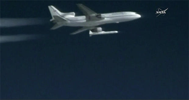
A 51,000-pound Orbital ATK rocket dropped from a repurposed jetliner over the Atlantic Ocean boosted eight small satellites into orbit Thursday, kicking off a $157 million mission to measure hurricane intensity by monitoring how GPS navigation signals are distorted when they bounce off the turbulent water below a storm.
Flying 39,000 feet above the Atlantic about 100 miles east of Daytona Beach, Florida, Orbital ATK’s L-1011 “Stargazer” carrier jet dropped the winged Pegasus XL rocket at 8:37 a.m. EDT (GMT-5). Five seconds later, the booster’s solid-fuel first-stage motor ignited with a rush of fiery exhaust, and the rocket shot ahead, quickly angling upward in a steep climb to space.
A launch try Monday was called off at the last minute because of trouble with a circuit breaker in the jet’s rocket release mechanism. Another delay was ordered to correct a data table used by the satellites’ computers.
But it was clear sailing Thursday, and all three of the 55-foot-long booster’s solid-propellant stages fired as planned, boosting the satellites into a 317-mile high-orbit. Five minutes after the third stage burned out, the eight Cyclone Global Navigation Satellite System -- CYGNSS -- spacecraft were released, two at a time, to fly on their own.
“All three stages performed beautifully, no issues at all with the Pegasus launch vehicle performance,” said NASA Launch Director Tim Dunn.
Eventually spaced 3,000 miles apart in an orbit carrying them 35 degrees to either side of the equator, the solar-powered satellites will constantly monitor the ocean surface below, measuring reflected signals from GPS satellites and calculating hurricane wind speeds based on how the navigation signals are affected by the roughness of the water.
“This is going to be looking at hurricanes, it’s going to be focusing on the surface winds, which is the area of highest dynamic energy in a hurricane, which helps influence how intense the hurricane’s going to be,” said Christine Bonniksen, CYGNSS program executive at NASA Headquarters.
“We’re hoping to learn through this mission information to better understand how those hurricanes grow and intensify.”
The CYGNSS satellite readings will be similar to those collected by Orion P3 “hurricane hunter” aircraft that fly through approaching hurricanes.
“You can think of this kind of like they’re being individual, virtual P3 airplanes somewhere in the tropics,” said Chris Ruf, CYGNSS principal investigator at the University of Michigan. “With eight satellites and each satellite able to make four measurements of the wind, it’s kind of like having 32 virtual P3 airplanes (measuring) winds at all times.”
Because of Earth’s rotation and other factors, a single satellite like NASA’s Tropical Rainfall Measuring Mission, or TRMM, needs three days to revisit a storm.
“With eight satellites, there’s about seven hours between measurements at any given spot in the tropics (around the world) on average,” Ruf said. “So we’re able to make measurements much more often than that three day refresh rate.”
The $157 million mission, managed by NASA, the Southwest Research Institute and the University of Michigan’s Department of Climate and Space Sciences and Engineering, is the first in NASA”s Earth Venture Program, which is focused on relatively low-cost Earth science missions.
Earlier satellites were unable to accurately measure hurricane wind speeds near the eyewall of a storm because the remote sensing technology could not “see” through rain. But the GPS signals used by the CYGNSS satellites pass through rain without any problem.
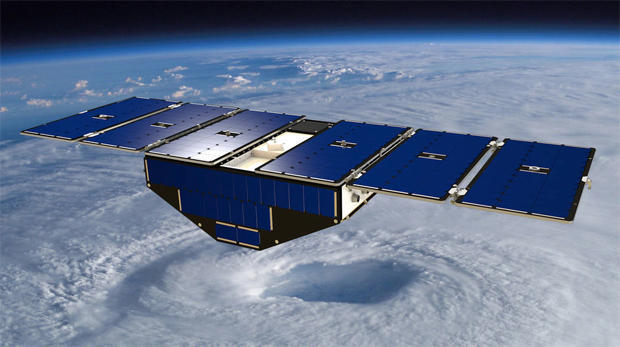
Each 64-pound CYGNSS spacecraft will receive GPS signals directly from the navigation satellites as well as reflections from the ocean below. Signals bouncing off undisturbed water are relatively unchanged but reflections off rough water are smeared out. Analysis of that smearing allows scientists to, in effect, reverse engineer wind speeds.
“In general, the rougher the surface is due to increased wind speed, the more diffuse scattering there is, the less specular scattering there is and CYGNSS makes measurements every second,” Ruf said. “From that, we can derive the wind speed.”
“There’s enough processing horsepower on board to measure four of these specular (reflection) points at a time. So it’s always tracking where these points are, and it takes the best four in the antenna pattern and processes them into winds.”
The goal of the CYGNSS mission is to improve forecasters’ knowledge of wind speeds near the eyewall and better predict storm surge and wind intensity at landfall.
“Being able to predict where a storm is going to make landfall has gotten steadily better, (but) being able to predict how strong it’s going to be when it does make landfall has not improved anywhere near as much,” Ruf said. “The general consensus on why that is ... is because of our inability to measure what’s going on in the middle of the storm.
“So what we’re hoping in the end will happen with this data ... is that our ability to forecast how strong a hurricane is going to be when it makes landfall will get much better.”