Arctic air mass to impact southeast Michigan through Wednesday

(CBS DETROIT) — An arctic air mass will impact all of southeast Michigan through Wednesday as the coldest temperatures of the winter so far arrive this week.
A cold weather advisory is in effect through Wednesday for all of the region.
Expect dangerously low wind chill temperatures between -15 and -25 degrees the next few nights. There will be little relief during the daylight hours with high temperatures in the single digits and wind chills at or below -10 degrees.
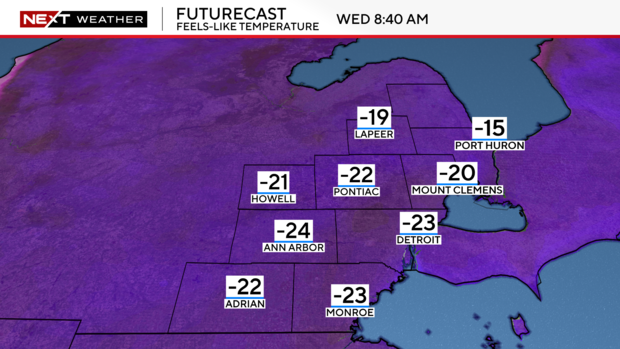
Monday morning started out with wind chill temperatures near -13 degrees, and gusty winds throughout the day will keep wind chills below zero degrees. The coldest conditions are expected Tuesday and Wednesday mornings.

Sporadic lake effect snow showers are likely through the week, especially late Monday into Tuesday morning, with minor accumulation possible.
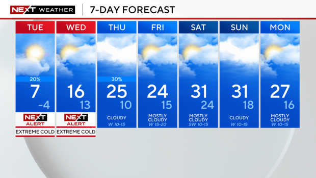
Temperatures are forecasted to warm to the 20s Thursday and Friday, but morning wind chills both days will still be near zero degrees.
The cold winds can cause frostbite on exposed skin in as little as 30 minutes. Frostbite and hypothermia can occur if precautions are not taken. Make sure to wear hats and gloves, and bring pets indoors. Anyone traveling should carry a winter survival kit that has extra warm clothes for temperatures outside the vehicle.
A cold weather advisory is issued when wind chills reach -15 to -24 degrees.


