Chicago Weather: Snow Snags Veterans Day Morning Commute; Bitter Cold To Follow
CHICAGO (CBS) -- Snow blowing through the area Monday morning is set to dump accumulations of up to 6 inches on the ground – making for a messy morning commute.
Plows were out very early, trying to keep the roads clear for the morning commute, but many drivers went too fast for the conditions, leading to a number of crashes Monday morning, though no serious injuries have been reported.
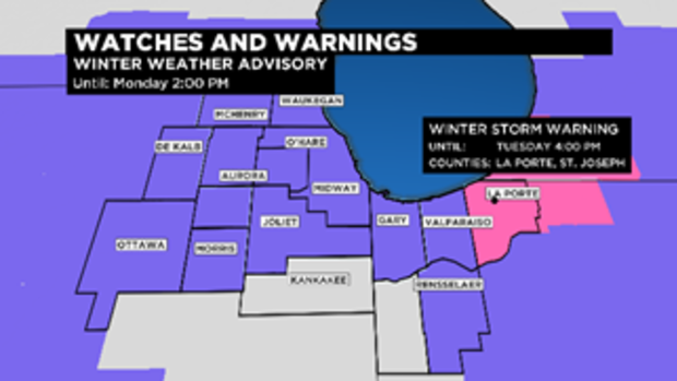
The heaviest snowfall was expected over the northern and central parts of the area. The National Weather Service has issued a winter weather advisory, which is in effect until 2 p.m.
Total accumulations are expected to reach 3 to 6 inches, with the heaviest snowfall expected over the northern and central parts of the Chicago area. Snow totals were expected to amount to 2 to 4 in the city.
Areas near the lake will see the most snow, with locally heavier snowfall possible for areas that find themselves parked under a lake effect plume. Isolated areas along the lakefront could even see more than 6 inches.
The morning rush will be scaled back because of the Veterans Day holiday, but officials warn that travel will be disrupted just the same.
Meantime, a winter storm warning has been issued for LaPorte and St. Joseph counties in Indiana, and Berrien and Cass counties in southwest Michigan, until 4 p.m. Chicago time on Monday. Those areas could get 5 to 9 inches of snow during the storm.
Meanwhile, the powerful winds coming down Lake Michigan will also create lakeshore flooding and erosion concerns. Large waves through Tuesday could reach levels of 10 to 12 feet in northern Illinois and along the Indiana shore.
A lakeshore flood advisory is in effect for Cook and Lake counties in Illinois until noon, while a lakeshore flood warning is in effect for Lake and Porter counties in Indiana until 4 p.m.
Illinois State Police reminded everyone that extreme weather can make for dangerous driving conditions. They advised that motorists be sure their tires are properly inflated and make sure windshield wipers are in good shape and all fluids are at sufficient levels.
Also advised is carrying an emergency car kit with jumper cables, flares or reflectors, windshield washer fluid, an ice scraper, traction material, blankets, non-perishable food, water, and a first-aid kit, the ISP said.
Indiana State Police also advised that drivers leave earlier, increase following distances between vehicles, turn on headlights, and pack a blanket, water, snacks, and a cellphone charger. Drivers should also watch out for snow plows and emergency responders, and should clean entire windows and windshields of ice and snow – not just enough space to see through.
The Chicago Office of Emergency Management and Communications (OEMC) advised people to prepare ahead of time for their Monday morning commute. Meanwhile, the Chicago Department of Streets and Sanitation will put out more than 200 snow removal spreaders on Sunday night and add more as crews and conditions warrant.
To watch the city's snow removal fleet in real time, go to http://www.chicagoshovels.org.
In Aurora, the forecast has been deemed severe enough to call off a Veterans Day Parade that had been planned.
"With the weather forecast calling for snow and wind chill temperatures in the low teens, we want to make sure everyone is safe," Mayor Richard C. Irvin said in a news release. "Many of our parade units consisted of military veterans who are senior citizens and youth performers from area schools. We can't have them out in the elements for an extended period of time."
There will still be a Veterans Day ceremony, which will be held inside in the Aurora City Hall at 10:15 a.m. Doors will open at 9:45 a.m., the city said.
Meanwhile, temperatures on Monday will likely be going down much of the day, reaching a high of 28 early in the day. From Monday night through Tuesday night, the other shoe drops as temperatures drop to what would be a cold day even by January standards.
The high on Monday is only in the upper 20s. Tuesday's high is now forecast at a mere 22. Lows will drop to the low teens on Monday night, with wind chills near zero and as low as minus 10 Monday night into Tuesday.
Early Tuesday morning, the forecast low is only 11. That's right, 11 – and that's not the wind chill factor, it's the actual temperature. Believe it or not, that would not set a record – the record low for Tuesday, Nov. 12 in Chicago is 8 degrees.
However, the forecast low of 28 will match the record low high for Nov. 11 in Chicago, and the forecast low of 22 for Tuesday will beat the record low high for Nov. 12, which is also 28.
The OEMC reminded everyone to take extra precautions in the cold and to be sure to check on seniors, those living alone, or neighbors and family – particularly those with disabilities.
The Fire Department also recommends that people refrain from using space heaters altogether if possible, and that any space heater that is used is UL certified and at least 3 feet from anything that can catch fire. Residents are also reminded they must have working carbon monoxide detectors that can detect leaks from a failing heating system.
Smoke detectors should also be kept in working order, and frozen pipes should only be thawed with a dryer or a heating pad – never candles or an open flame.
OEMC also advised avoiding unnecessary trips; wearing layers; keeping your head, hands, and feet covered when outdoors; staying dry, because moisture can undermine the insulating effect of clothing; and paying attention to daily needs. To request shelter, information on warming centers, or a wellbeing check, call 311 – or access the 311 online portal or the CHI311 app.
For more information on warming centers, click here.
Temperatures will start climbing again Wednesday, reaching the low 30s, and possibly rising to the 40s again by Friday.


