Showers to persist overnight Thursday into Friday in Chicago


CHICAGO (CBS) — Pouring rain, hail, and strong winds returned to the Chicago area Thursday night after an earlier round in the afternoon.
A new severe thunderstorm warning was issued for Cook County, Illinois, and Lake County, Indiana Friday night, as more storms pounded on through.
The storms in the afternoon and evening were fueled by hot, humid weather earlier in the day. The area saw the warmest temperatures of the year thus far, with highs on Thursday in the lower 80s in parts of Chicago and the middle 80s in the south.
A severe thunderstorm warning was also issued in the afternoon, when a small, but strong thunderstorm cell hit the area. Around 3 p.m., rain began pouring in downtown Chicago and hailstones also fell. The rain stopped within 15 minutes.
The National Weather Service confirmed reports of hail as large as an inch, and wind gusts of nearly 60 mph were reported in the Logan Square neighborhood.
Later in the afternoon, another dramatic storm passed over the city, also bringing hail, lightning, and gusty winds.
Storm damage reported around Chicago
The midafternoon storm system left a trail of damage. In the Logan Square neighborhood, a large tree came down at Campbell Avenue and Altgeld Street.
In the Lincoln Park neighborhood, the roof partially collapsed at a building at Medill, Ashland, and Clybourn avenues that houses a swimming school.
It appeared roofing material was blown off the roof during a thunderstorm, taking down power lines, gas lines, and some heating, ventilation, and air conditioning units on the roof. Part of the roof also collapsed due to the damaged HVAC units.
Only one person was inside, and no one was injured. The building and a connected three-story building were evacuated.
On the city's Southwest Side near Midway International Airport, a branch came barreling down into the windshield of a parked car. Many trees came down in the area, along with at least one power line.
"The electricity is out, half of my fence is out, the post is out completely, and a lot of the cables are hanging," said Jesus Cardenas, who lives in the area.
More rain coming overnight
While rain was isolated throughout the day, widespread rain and thunderstorms move in overnight, when a nice soaking of 0.50" to 0.75" is expected. Scattered showers and storms were expected to persist until about 2 a.m.
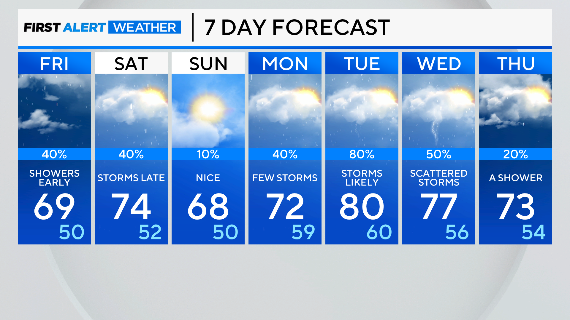
A few morning showers linger Friday, then we will enjoy a mostly cloudy, cooler day with a northeast wind off the lake keeping highs in the 60s. Weekend plans look driest on Sunday, as we are tracking another round of showers and storms possible Saturday afternoon and evening.
Tonight: Rain and thunderstorms are likely. Low: 58
Tomorrow: Morning showers, then mostly cloudy and cooler. High: 69
Saturday: Dry early, then scattered late-day thunderstorms. High: 74