Chicago Weather Alert: Freezing rain, flooding, ice wreak havoc
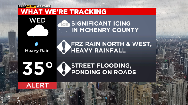
CHICAGO (CBS) -- Heavy rainfall hit Chicago area Wednesday, and triggered street flooding and ponding on the roadways in the afternoon. Meanwhile, ice accumulations remained a concern Wednesday night in areas north and west of Chicago.
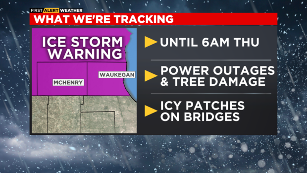
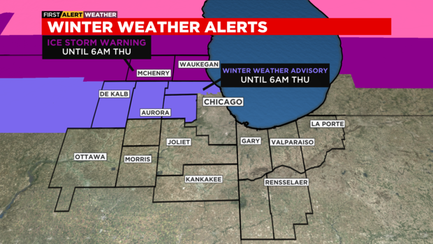
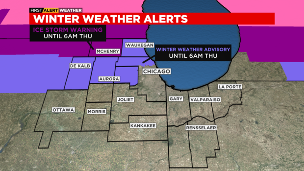
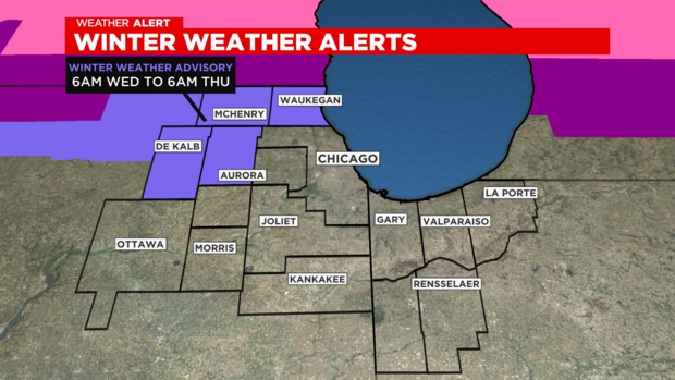
An ice storm warning is in effect for McHenry County until 6 a.m. Thursday. A Winter Weather Advisory was issued for Lake, Kane, and DeKalb counties for sleet and freezing rain accumulation concerns.
Dangerous accumulations of ice took down trees and power lines and knocked out power in some areas, and made for treacherous situations on some suburban streets and driveways.
The outlook for Thursday
An Ice Storm Warning is in effect for Lake (IL) and McHenry County until 6 a.m. A Winter Weather Advisory has been posted until 6am for Northern Cook County, Kane, and De Kalb County.
We won't have much additional precipitation after 2 a.m., but the ice accumulation from Thursday is weight down trees, snapping branches and bringing down powerlines in some locations. This mainly is happening in Lake and McHenry County, but we are also getting reports of this happening in northern Cook County and DeKalb County.
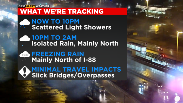
Most roads will be fine, but untreated secondary roads and overpasses/bridges could be icy through sunrise.
Ice, freezing rain make for dangerous conditions in northwest suburbs
In the northwest suburbs, the rain started falling early Wednesday and had been a constant downpour – turning the shower into ice.
In Crystal Lake, ice had the grass crunching and the cars completely encased – and power lines were drooping treacherously lower and lower as the ice weighed them down.
Back a little closer to the city in Arlington Heights, the winds toppled a tree onto the garage. There was a sport-utility vehicle inside the garage, but luckily, no one was inside the vehicle.
In Villa Park, trees and power lines snapped under the weight of a thick layer of icicles.
And while plow and salt trucks were out early to keep the road passable, there was little crews could do near Buffalo Grove – where a huge tree snapped and blocked four lanes of traffic.
"Our neighborhood is all down right now. We actually had a tree fall on an ambulance. So we're going home, staying put by our fire," said McHenry County resident Briana Mesick.
"We live in Oakwood Hills," said Trystan Greenenwald. "The trees are falling all around us. We've been trying to help the neighbors out."
Mesick, Greenenwald and their friends discovered just how serious the ice storm was when power lines covered in ice knocked out power to an entire shopping center in Cary.
Heavy snow, ice, power outages seen well beyond Chicago area
The severe weather Wednesday did not just hit us in Illinois.
A total of 76 million people across the United States were under some kind of weather advisory Wednesday – and plenty of places had a more challenging experience than Chicago.
The Dakotas were hit particularly hard – with blizzard-like conditions and temperatures below zero.
In the Twin Cities, about 4 inches of snow had fallen by Wednesday evening – but another 9 to 13 inches could be coming by Thursday afternoon.
Our neighbors directly to the north were also digging out Wednesday evening, In Wausau, Wisconsin, about 5 inches of snow fell overnight.
But it is not over yet. That second wave mentioned in the Minneapolis-St. Paul area is expected to hit northern Wisconsin on Thursday too – possibly dumping another foot before the end of the day.
A little closer to home, the weather in Milwaukee Wednesday night was more reminiscent of that of the northern counties in the Chicago area. A wintry mix fell through the evening, with sleet being dominant in Milwaukee County, accumulating freezing rain to the south, and mainly snow north into Fond du Lac and Sheboygan counties, CBS 58 Milwaukee reported.
Between .25 and .5 inch of freezing rain had fallen in Kenosha, Racine, and Walworth counties in Wisconsin as of early in the evening.
More than 20,000 customers in Wisconsin lost power during the winter storm Wednesday, prompting Gov. Tony Evers to declare a state of emergency, CBS affiliate WISC-TV 3 in Madison reported.
The massive winter storm disrupted thousands of flights across the country Wednesday. Nationwide, 1,700 flights were canceled and nearly 6,000 more were delayed.
In Chicago, 51 flights were canceled at O'Hare International Airport, and 46 were canceled at Midway International Airport.
Power out to more than 100,000 customers
As of 8:25 p.m., ComEd reported 2,216 active outages affecting 104,934 customers.
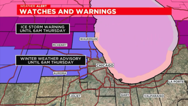
Ice storm warning for McHenry, Lake counties
An Ice Storm Warning is in effect until 6 a.m. Thursday for McHenry & Lake (IL) County. 0.20" to 0.50" of ice accumulation is possible.
Winter Weather Advisory has been posted until 6 a.m. Thursday for Northern Cook County, Kane, and DeKalb. A light glaze to a tenth of an inch of ice accumulation is possible.
Chief Meteorologist Albert Ramon has the latest weather forecast
Six Flags Great America to remain closed today due to weather (it's a joke)
Six Flags Great America announced on Twitter that due to the inclement weather, the park would remain closed Wednesday.
This, of course, was a joke -- and they admitted as much. "Remain" is the key word in their tweet. It's the middle of winter, and Six Flags Great America would be closed anyway.
The amusement park will open for the new season on Saturday, April 22.
Parts of Lake, McHenry counties coated in ice
McHenry County crews battle rain, possibly icy road conditions
An ice storm warning has been in effect for McHenry County.
CBS 2's Jackie Kostek was in Woodstock all afternoon monitoring conditions.
That rain has been falling steadily all afternoon in McHenry County. So far, in Woodstock it hasn't transitioned into that hard falling freezing rain and because of that, the roadways are wet but, for the most part, haven't gotten that icy glaze yet.
Still, ice is forming on trees, signs and mailboxes.
CBS 2 caught up with the folks from the McHenry County Division of Transportation. They've been in preparation mode for a couple of days.
Photos: Ice coating in McHenry County
CBS 2's Jackie Kostek reports from Richmond, where ice is covering trees and mailboxes this afternoon.
Ice still a threat to the north, heavy rain to the south
Ice Storm Warning is in effect until 6am Thursday for McHenry County. Up to 0.50" of ice accumulation is possible.

Winter Weather Advisory has been posted until 6am Thursday for Northern Cook County, Kane, De Kalb, and Lake County (IL). A light glaze to a tenth of an inch of ice accumulation is possible. DuPage County is no longer part of that Winter Weather Advisory.
Impacts-
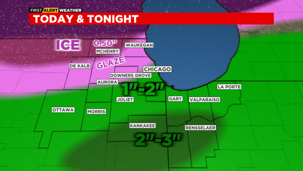
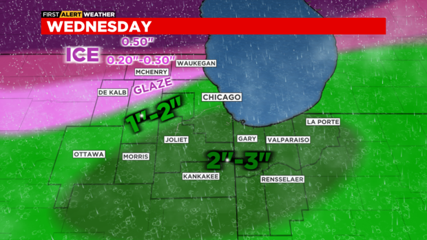
Accumulation of ice from near Glencoe to Des Plaines to Downers Grove to De Kalb and points northward. A glaze to 0.10" accumulation of ice is possible in most of this area. Up to 0.50" accumulation of ice is possible in McHenry County, where significant impacts to travel will be likely.
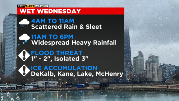
From Chicago southward, heavy rainfall is the main concern. Widespread 1 to 2 inches of rainfall, with higher amounts possible (up to 3 inches) near Kankakee and eastward to Newton & Jasper County. Street flooding and roadway ponding will be possible through the mid-evening hours.
Timeline-
Now to 7pm: Widespread rain, with freezing rain to the north & west and heavy downpours near and south of I-80.
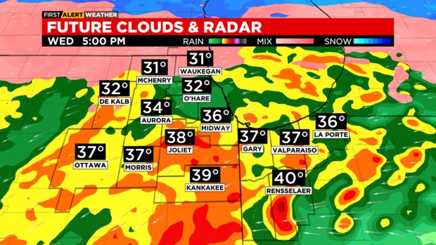
7pm to Midnight: Rain coverage and intensity decreases. Still some light freezing rain along the Illinois and Wisconsin state line.
Midnight to 5am: Isolate pockets of freezing rain and drizzle possible to the north.
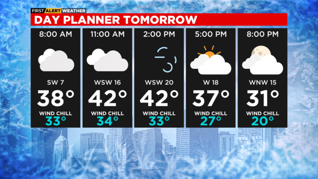
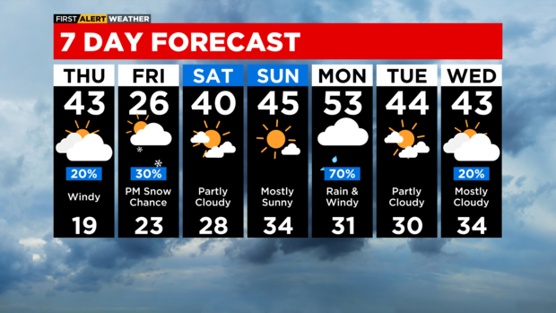
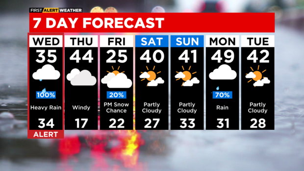
THURSDAY: A 20% chance of rain in the morning, then mostly cloudy and windy in the afternoon. A southwest wind could gust as high as 40 mph. High 43°
THURSDAY NIGHT: Partly cloudy and very cold. Low 19°
FRIDAY: Mostly cloudy and cold. A chance for light snow in the evening. High 26°
WEEKEND: Partly cloudy with low 40s in Saturday, mostly sunny with mid 40s on Sunday.
More than 150 flights cancelled at O'Hare and Midway
As of noon, a total of 153 flights have been cancelled at O'Hare and Midway airports.
At O'Hare International Airport, a total of 110 flights have been cancelled, and delays are averaging less than 15 minutes for remaining flights.
At Midway International Airport, a total of 43 flights have been cancelled, and delays are averaging less than 15 minutes for remaining flights.
McHenry County could see up to a half inch of ice
The worst of today's weather will be in McHenry County where an Ice Storm Warning is in effect until 6 a.m. Thursday.
Up to a half inch of ice accumulation is possible, which will not only make for very dangerous driving conditions, but could impact power as ice will weigh down trees, snapping them and falling on power lines.
A light glaze to a tenth of an inch of ice accumulation is possible in Northern Cook County, DuPage, Kane, De Kalb and Lake County (IL). Slippery travel is likely here, so Winter Weather Advisories have been posted until 6 a.m. Thursday.

For Chicago and points southward, heavy rainfall is the main threat. One to two inches of rainfall is possible and some of it will be heavy this afternoon and early evening. Ponding on roadways and street flooding is possible.
More than 100 flights cancelled at O'Hare and Midway
As of 10 a.m., a total of 130 flights have been cancelled at O'Hare and Midway airports.
At O'Hare International Airport, a total of 93 flights have been cancelled, and delays are averaging less than 15 minutes for remaining flights.
At Midway International Airport, a total of 37 flights have been cancelled, and delays are averaging less than 15 minutes for remaining flights.
Flood watches issued for parts of Illinois and Indiana
The National Weather Service issued a flood watch for:
- The Little Calumet River from Indiana State Road 912 in Hammond to Thorn Creek in South Holland from late Wednesday night to late Thursday evening.
- Sugar Creek from near Milford to the confluence with the Iroquois River in Watseka from Thursday afternoon to Saturday morning.
- The Iroquois River from U.S. Highway 41 to the confluence with Sugar Creek in Watseka from Friday afternoon to Monday evening.
- The Iroquois River from near Interstate 65 east of Foresman to near U.S. 41 north of Kentland from Friday evening through Sunday afternoon.
A Flood Watch means water levels above flood stage are possible, but not yet certain, based upon the latest forecasts. People living along rivers and streams in the watch area should monitor the latest forecasts and be prepared to take action should flooding develop.
CBS 2's Ed Curran with update on incoming wintry weather
Downtown rainfall
Rain is starting to fall downtown, leaving commuters with wet road conditions.
Heavy rainfall will turn icy as the day progresses.
Commuters should allow for extra time when heading out.
Here's what you can expect...
9 a.m. to noon: Persistent rain mixed with sleet. Isolated downpours.
Noon to 6 p.m.: Widespread downpours, thunder and lighting. Ponding on roadways & hydroplaning likely. Some street flooding possible. Area rivers and creeks rise.
6 p.m. to 8 p.m.: Decrease in intensity and coverage of rainfall.
School closings due to incoming weather
Ice Storm Warning
An Ice Storm Warning is in effect for McHenry County until 6 a.m. Thursday.
Two big impacts for Wednesday
- Heavy rainfall in the afternoon that could trigger street flooding and ponding on the roadways.
- Ice accumulations possible for areas north and west of Chicago.
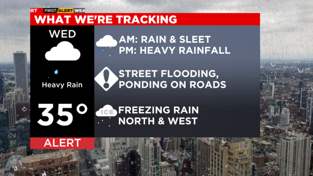
A Winter Weather Advisory is in effect for McHenry, Lake (IL), Kane and De Kalb County starting at 6 a.m. Wednesday to 6 a.m. Thursday. This advisory is for the possibility of sleet and freezing rain accumulation. Ice accumulation of 0.20" to 0.30" is possible in Lake and McHenry County, 0.10" of ice for Kane and De Kalb.
4 a.m. to 9 a.m.: Increasing rain and sleet. Some freezing rain possible, especially north and west of Chicago. Increasing traffic issues are likely as the morning goes on, but especially by the second half of rush hour with isolated icing issues.
9 a.m. to noon: Persistent rain mixed with sleet. Isolated downpours.
Noon to 6 p.m.: Widespread downpours, thunder and lighting. Ponding on roadways & hydroplaning likely. Some street flooding possible. Area rivers and creeks rise.
6 p.m. to 8 p.m.: Decrease in intensity and coverage of rainfall.


