What dictates the kind of snow we get? Here's how winter precipitation works

BALTIMORE -- While winter officially arrives December 21, 2023, at 10:27 p.m., winter weather in the form of snow or ice can arrive as early as October in Maryland.
In fact, winter weather is possible anytime from October through May across Maryland, but the most common months for it are December through March.
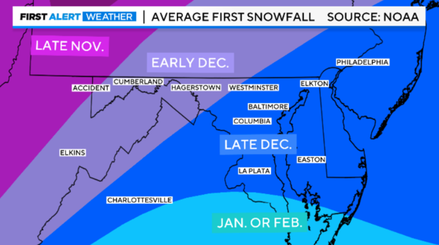
On average, our first inch of snowfall in and around Baltimore usually takes place in late December. Across central and western Maryland the first inch is usually measured by early December. Finally, in extreme western Maryland, in the mountains, places like Accident and Oakland typically pick up their first inch of snow by late November.
When people think of winter in Maryland, they typically think about snow! And while our winter weather certainly does come in the form of snow, it can also come as sleet and freezing rain. Any of these forms of winter precipitation can cause severe to major travel disruptions, school delays and closings, and even power outages in some cases.
The atmosphere is like a cake. Like a layer cake, which may have different flavors, the atmosphere can have different temperatures at different heights. This leads to the different types of precipitation that we receive during our colder months.
To understand the different forms of winter precipitation, it's important to understand the different temperature profiles of the atmosphere associated with them.
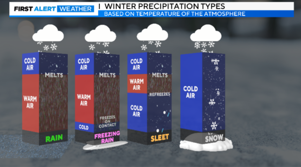
With all four types of precipitation, rain, freezing rain, sleet, and snow, the precipitation usually begins as snow up at the cloud level.
With rain, the snowflakes usually quickly melt into rain droplets, with a deep layer of warmer air (above 32 degrees) from the melting point of the snowflakes down to the ground.
When we experience freezing rain, one of the most dangerous forms of winter weather, snowflakes melt into rain droplets during their journey to the ground. However, right before the raindrop is about to make contact with the ground, the raindrop encounters air temperatures at 32 degrees or below. This allows the raindrop to freeze upon contact and turn into ice. This is known as freezing rain.
The reason why freezing rain is so problematic is because it accumulates as ice. Once you reach ¼" of ice accumulation, you can have tree limbs snapping, power outages, and dangerous driving conditions. During some of our worst freezing rain events, we've seen accumulations of ice greater than an inch. These come in the form of paralyzing ice storms.
When we experience sleet, snowflakes melt into raindrops beneath the cloud layer, however, the raindrops encounter another colder layer in the atmosphere on their journey down to the ground. This causes the raindrop to refreeze into an ice pellet. This ice pellet then falls to the ground.
Sleet, or ice pellets, usually bounce when they hit the ground. While sleet is a form of ice, it tends to be much less dangerous than freezing rain, as there is a bit of traction you can get when sleet accumulates. Sleet is notorious for cutting down on snowfall accumulations during big storms.
This happens when a mid-level layer of warmer sneaks into the atmosphere. This typically happens during some of our bigger winter storms.
Finally, snow! Snow falls when the entire atmosphere is near or below 32 degrees from the cloud all the way to the ground, this allows for the snowflakes to stay intact all of the way to the ground.
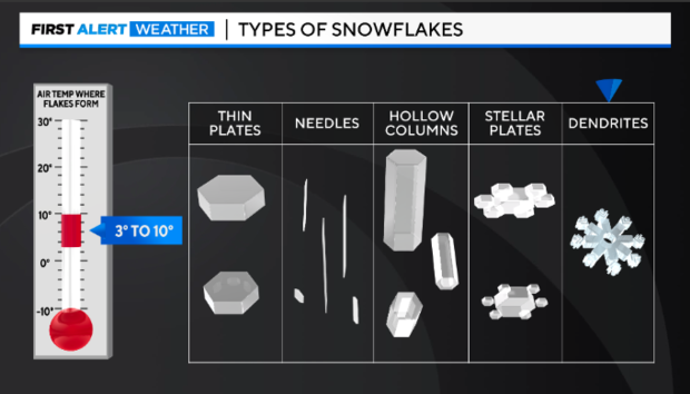
Believe it or not, there are different types or classifications of snowflakes. The different types of snowflakes are caused by different temperatures in the cloud layer. The type of snowflakes that cause the biggest accumulations tend to be dendrites, due to their larger surface area. They can stack up quickly causing larger accumulations!
Here are the different types of snowflakes based on the temperature in the cloud layer where they form.
Thin Plates:
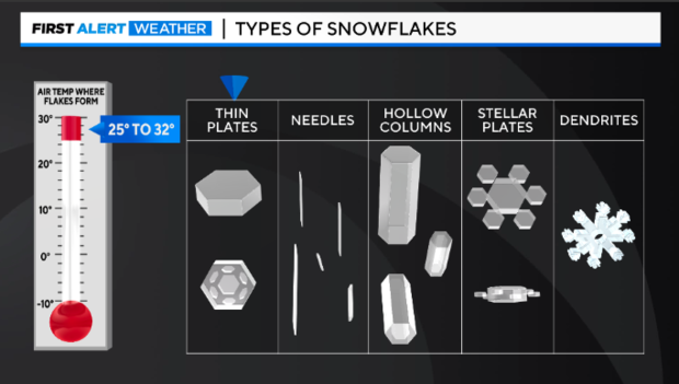
Needles:
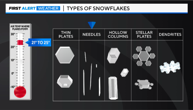
Hollow Columns:
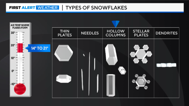
Stellar Plates:
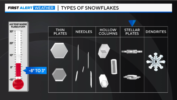
Dendrites:
Note: This article was first published December 7, 2024.


